Shaw Creek Topo Map Montana
To zoom in, hover over the map of Shaw Creek
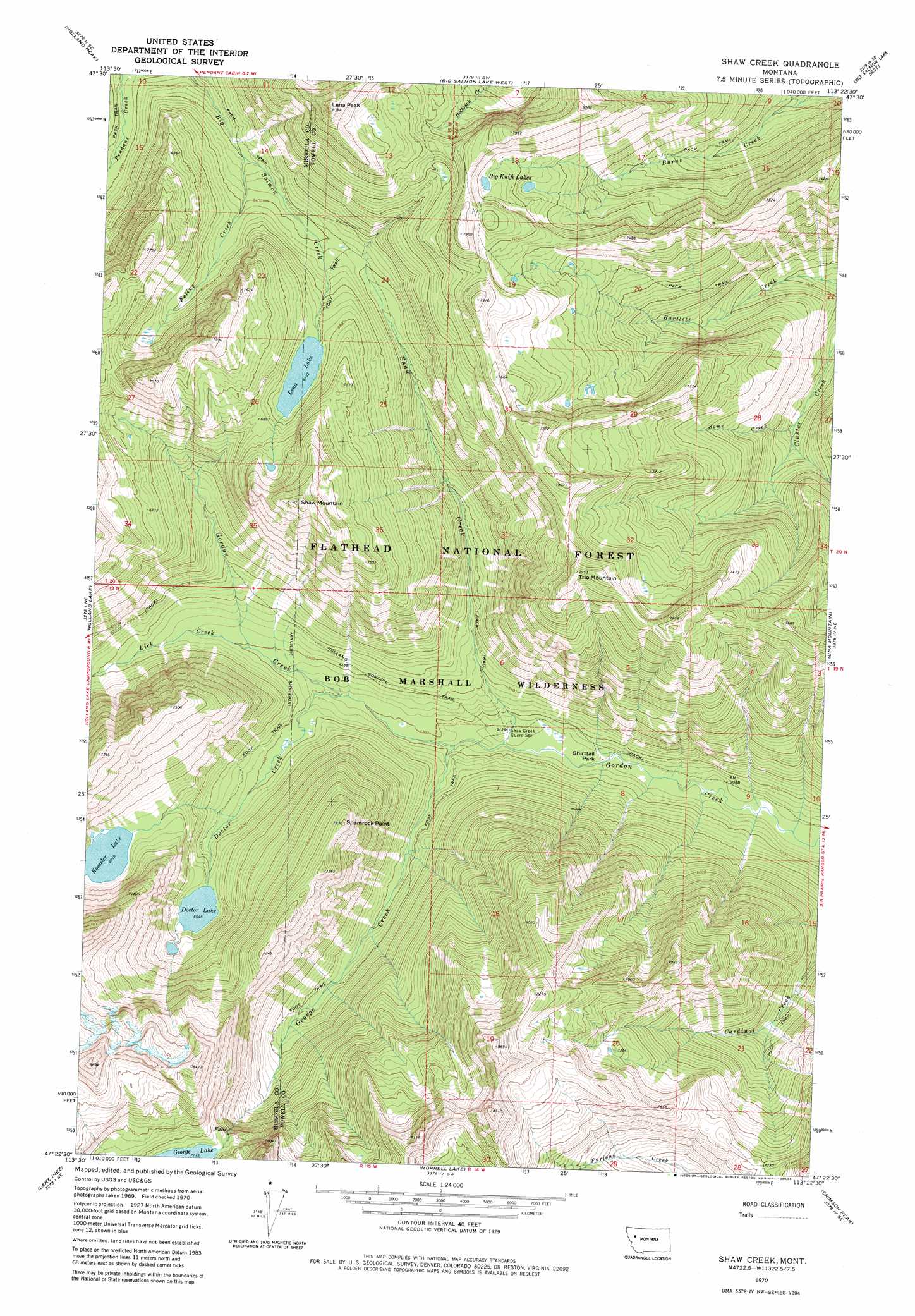
USGS Topo Quad 47113d4 - 1:24,000 scale
| Topo Map Name: | Shaw Creek |
| USGS Topo Quad ID: | 47113d4 |
| Print Size: | ca. 21 1/4" wide x 27" high |
| Southeast Coordinates: | 47.375° N latitude / 113.375° W longitude |
| Map Center Coordinates: | 47.4375° N latitude / 113.4375° W longitude |
| U.S. State: | MT |
| Filename: | o47113d4.jpg |
| Download Map JPG Image: | Shaw Creek topo map 1:24,000 scale |
| Map Type: | Topographic |
| Topo Series: | 7.5´ |
| Map Scale: | 1:24,000 |
| Source of Map Images: | United States Geological Survey (USGS) |
| Alternate Map Versions: |
Shaw Creek MT 1970, updated 1973 Download PDF Buy paper map Shaw Creek MT 1970, updated 1980 Download PDF Buy paper map Shaw Creek MT 1970, updated 1986 Download PDF Buy paper map Shaw Creek MT 2011 Download PDF Buy paper map Shaw Creek MT 2014 Download PDF Buy paper map |
| FStopo: | US Forest Service topo Shaw Creek is available: Download FStopo PDF Download FStopo TIF |
1:24,000 Topo Quads surrounding Shaw Creek
Swan Peak |
Sunburst Lake |
Marmot Mountain |
Pagoda Mountain |
Amphitheatre Mountain |
Condon |
Holland Peak |
Big Salmon Lake West |
Big Salmon Lake East |
Haystack Mountain |
Cygnet Lake |
Holland Lake |
Shaw Creek |
Una Mountain |
Pilot Peak |
Lake Marshall |
Lake Inez |
Morrell Lake |
Crimson Peak |
Hahn Creek Pass |
Upper Jocko Lake |
Seeley Lake West |
Seeley Lake East |
Morrell Mountain |
Dunham Point |
> Back to 47113a1 at 1:100,000 scale
> Back to 47112a1 at 1:250,000 scale
> Back to U.S. Topo Maps home
Shaw Creek topo map: Gazetteer
Shaw Creek: Flats
Shirttail Park elevation 1554m 5098′Shaw Creek: Lakes
Big Knife Lakes elevation 2232m 7322′Doctor Lake elevation 1722m 5649′
Koessler Lake elevation 1833m 6013′
Lena Lake elevation 2053m 6735′
Shaw Creek: Streams
Cluster Creek elevation 1656m 5433′Doctor Creek elevation 1595m 5232′
Feline Creek elevation 1896m 6220′
George Creek elevation 1566m 5137′
Lick Creek elevation 1646m 5400′
Shaw Creek elevation 1562m 5124′
Some Creek elevation 1701m 5580′
Shaw Creek: Summits
Lena Peak elevation 2495m 8185′Shamrock Point elevation 2199m 7214′
Shaw Mountain elevation 2479m 8133′
Trio Mountain elevation 2420m 7939′
Shaw Creek: Trails
Holland Gordon Trail elevation 1648m 5406′Shaw Creek digital topo map on disk
Buy this Shaw Creek topo map showing relief, roads, GPS coordinates and other geographical features, as a high-resolution digital map file on DVD: