Fort Connah Topo Map Montana
To zoom in, hover over the map of Fort Connah
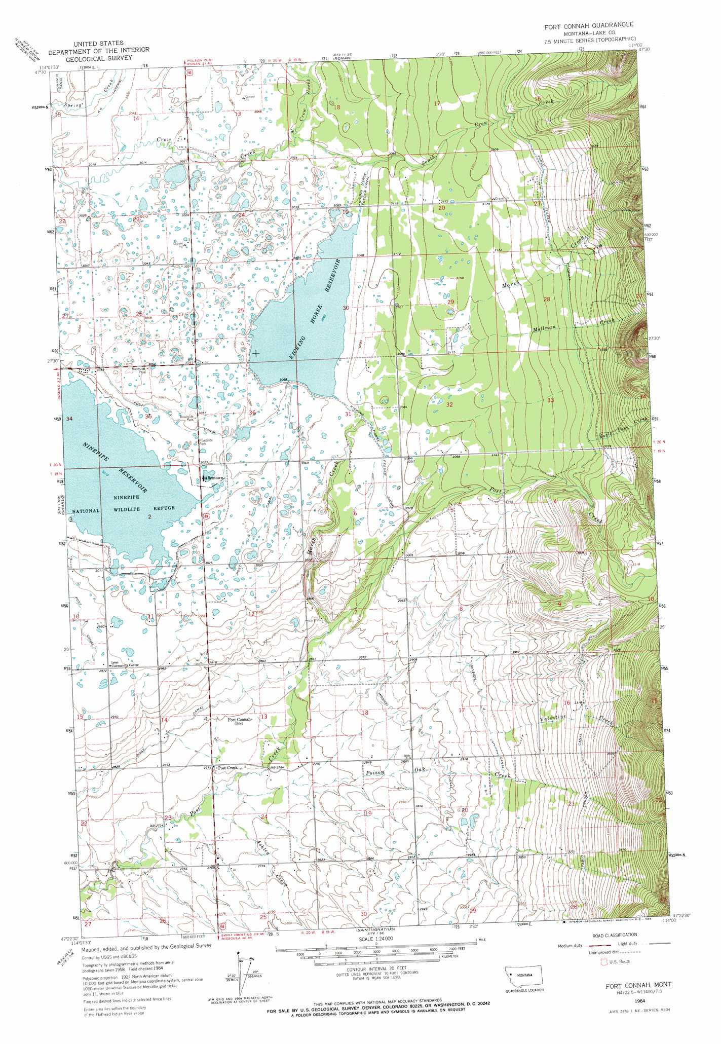
USGS Topo Quad 47114d1 - 1:24,000 scale
| Topo Map Name: | Fort Connah |
| USGS Topo Quad ID: | 47114d1 |
| Print Size: | ca. 21 1/4" wide x 27" high |
| Southeast Coordinates: | 47.375° N latitude / 114° W longitude |
| Map Center Coordinates: | 47.4375° N latitude / 114.0625° W longitude |
| U.S. State: | MT |
| Filename: | o47114d1.jpg |
| Download Map JPG Image: | Fort Connah topo map 1:24,000 scale |
| Map Type: | Topographic |
| Topo Series: | 7.5´ |
| Map Scale: | 1:24,000 |
| Source of Map Images: | United States Geological Survey (USGS) |
| Alternate Map Versions: |
Fort Connah MT 1964, updated 1966 Download PDF Buy paper map Fort Connah MT 2011 Download PDF Buy paper map Fort Connah MT 2014 Download PDF Buy paper map |
1:24,000 Topo Quads surrounding Fort Connah
Buffalo Bridge |
Polson |
East Bay |
Cedar Lake |
Salmon Prairie |
Round Butte |
Lower Crow Reservoir |
Ronan |
Piper-Crow Pass |
Peck Lake |
Sloan |
Charlo |
Fort Connah |
Mount Harding |
Hemlock Lake |
Dixon |
Ravalli |
Saint Ignatius |
Saint Marys Lake |
Gray Wolf Lake |
Hewolf Mountain |
Saddle Mountain |
Arlee |
Gold Creek |
Belmore Sloughs |
> Back to 47114a1 at 1:100,000 scale
> Back to 47114a1 at 1:250,000 scale
> Back to U.S. Topo Maps home
Fort Connah topo map: Gazetteer
Fort Connah: Canals
Kicking Horse Feeder Canal elevation 935m 3067′Post G Canal elevation 927m 3041′
Ronan B Canal elevation 922m 3024′
Fort Connah: Dams
Kickinghorse Dam elevation 934m 3064′Fort Connah: Parks
Fort Connah Historical Marker elevation 854m 2801′Mission Mountain Wilderness Historical Marker elevation 926m 3038′
Ninepipe National Wildlife Refuge elevation 918m 3011′
Fort Connah: Populated Places
Allentown elevation 921m 3021′Kicking Horse elevation 934m 3064′
Post Creek elevation 844m 2769′
Fort Connah: Post Offices
Leon Post Office (historical) elevation 851m 2791′Fort Connah: Reservoirs
Kicking Horse Reservoir elevation 934m 3064′Kickinghorse Reservoir elevation 934m 3064′
Fort Connah: Streams
Ashley Creek elevation 834m 2736′Eagle Pass Creek elevation 1007m 3303′
Mollman Creek elevation 869m 2851′
North Crow Creek elevation 927m 3041′
Poison Oak Creek elevation 835m 2739′
South Crow Creek elevation 927m 3041′
Valentine Creek elevation 913m 2995′
Fort Connah: Wells
19N19W05DAA_01 Well elevation 960m 3149′19N19W06CCCB01 Well elevation 925m 3034′
19N19W07CCA_01 Well elevation 872m 2860′
19N19W09DBBD01 Well elevation 1035m 3395′
19N19W20BBA_01 Well elevation 879m 2883′
19N19W20BBAA01 Well elevation 881m 2890′
19N19W20CCC_01 Well elevation 889m 2916′
19N19W21CBCD01 Well elevation 931m 3054′
19N20W01BBC_01 Well elevation 920m 3018′
19N20W01DAA_01 Well elevation 933m 3061′
19N20W13CCA_01 Well elevation 848m 2782′
19N20W14BBA_01 Well elevation 910m 2985′
19N20W14BBB_01 Well elevation 908m 2979′
19N20W14CDD_01 Well elevation 872m 2860′
19N20W15DAAA01 Well elevation 898m 2946′
19N20W22AAAB01 Well elevation 864m 2834′
19N20W24CDDA01 Well elevation 843m 2765′
19N20W26ADD_01 Well elevation 842m 2762′
19N20W26BAB_01 Well elevation 832m 2729′
20N19W16BDCB01 Well elevation 958m 3143′
20N19W19DAA_01 Well elevation 948m 3110′
20N19W19DAD_01 Well elevation 950m 3116′
20N19W19DDA_01 Well elevation 950m 3116′
20N19W20ADDD01 Well elevation 970m 3182′
20N19W21BDA_01 Well elevation 999m 3277′
20N19W21BDD_01 Well elevation 1002m 3287′
20N19W31ACD_01 Well elevation 940m 3083′
20N19W32DCC_01 Well elevation 945m 3100′
20N20W14CAD_01 Well elevation 922m 3024′
20N20W15ADDD01 Well elevation 922m 3024′
20N20W22AAD_01 Well elevation 922m 3024′
20N20W25CCC_01 Well elevation 931m 3054′
20N20W26CCBD01 Well elevation 931m 3054′
Fort Connah digital topo map on disk
Buy this Fort Connah topo map showing relief, roads, GPS coordinates and other geographical features, as a high-resolution digital map file on DVD: