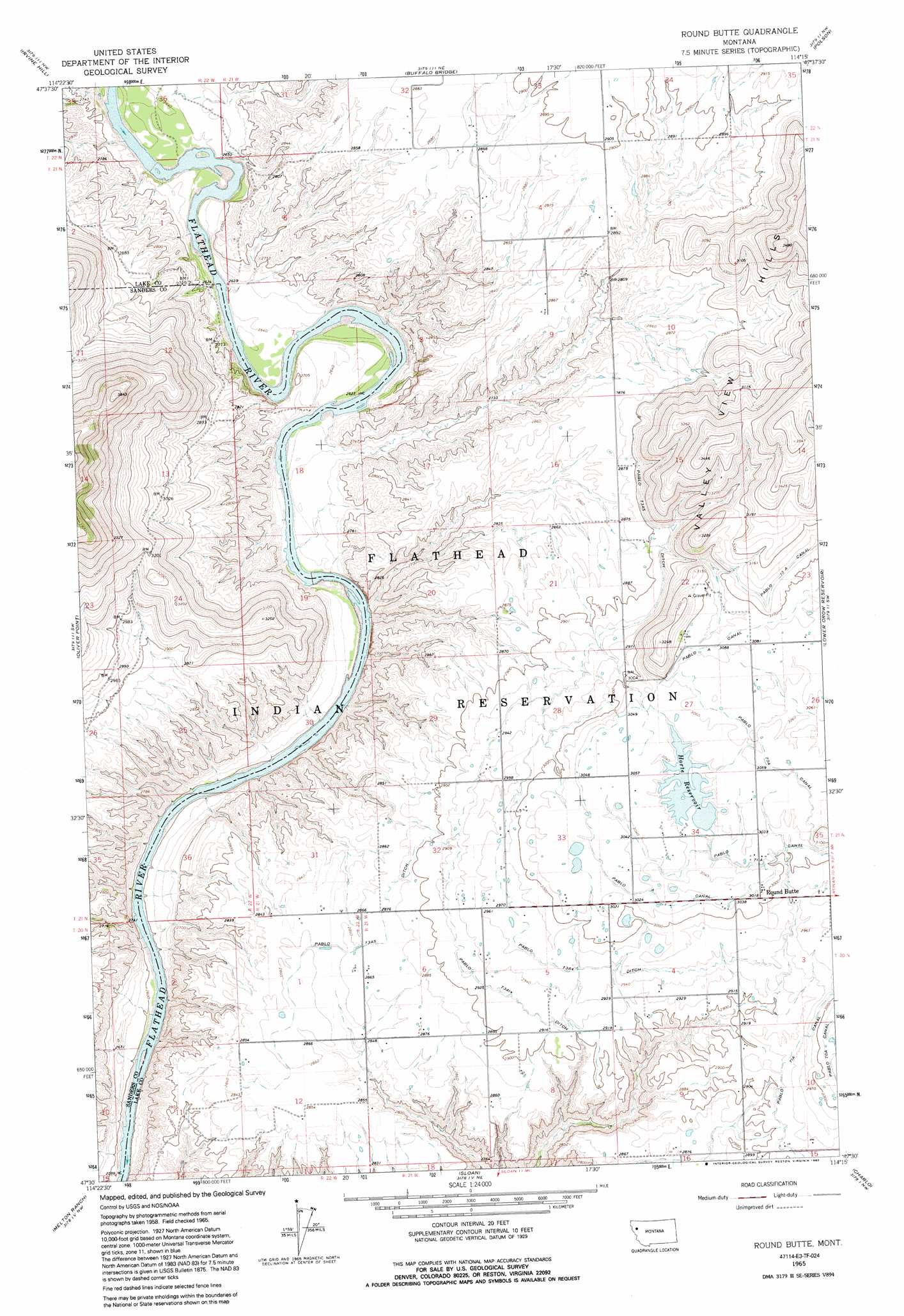
Round Butte Topo Map Montana
To zoom in, hover over the map of Round Butte
USGS Topo Quad 47114e3 - 1:24,000 scale
| Topo Map Name: | Round Butte |
| USGS Topo Quad ID: | 47114e3 |
| Print Size: | ca. 21 1/4" wide x 27" high |
| Southeast Coordinates: | 47.5° N latitude / 114.25° W longitude |
| Map Center Coordinates: | 47.5625° N latitude / 114.3125° W longitude |
| U.S. State: | MT |
| Filename: | o47114e3.jpg |
| Download Map JPG Image: | Round Butte topo map 1:24,000 scale |
| Map Type: | Topographic |
| Topo Series: | 7.5´ |
| Map Scale: | 1:24,000 |
| Source of Map Images: | United States Geological Survey (USGS) |
| Alternate Map Versions: |
Round Butte MT 1965, updated 1967 Download PDF Buy paper map Round Butte MT 1965, updated 1992 Download PDF Buy paper map Round Butte MT 2011 Download PDF Buy paper map Round Butte MT 2014 Download PDF Buy paper map |
1:24,000 Topo Quads surrounding Round Butte
Niarada |
Irvine Lookout Tower |
Elmo |
Wild Horse Island |
Bull Island |
Hot Springs Ne |
Irvine Hill |
Buffalo Bridge |
Polson |
East Bay |
Markle Pass |
Oliver Point |
Round Butte |
Lower Crow Reservoir |
Ronan |
Camas Prairie |
Melton Ranch |
Sloan |
Charlo |
Fort Connah |
Perma |
Mcdonald |
Dixon |
Ravalli |
Saint Ignatius |
> Back to 47114e1 at 1:100,000 scale
> Back to 47114a1 at 1:250,000 scale
> Back to U.S. Topo Maps home
Round Butte topo map: Gazetteer
Round Butte: Canals
Pablo 73A14 Ditch elevation 893m 2929′Pablo 73A4 Ditch elevation 905m 2969′
Pablo 73A5 Ditch elevation 895m 2936′
Round Butte: Dams
Horte Dam elevation 928m 3044′Round Butte: Populated Places
Round Butte elevation 919m 3015′Round Butte: Post Offices
Round Butte Post Office (historical) elevation 919m 3015′Round Butte: Reservoirs
Horte Reservoir elevation 926m 3038′Round Butte: Wells
20N21W10BCB_01 Well elevation 891m 2923′20N21W36CCD_01 Well elevation 915m 3001′
21N21W05BAAA01 Well elevation 875m 2870′
21N21W09AAB_01 Well elevation 879m 2883′
21N21W15CBB_01 Well elevation 883m 2896′
21N21W22DCC_01 Well elevation 943m 3093′
21N21W26BBA_01 Well elevation 938m 3077′
21N21W35CCC_01 Well elevation 922m 3024′
21N22W36BDCC01 Well elevation 796m 2611′
21N22W36BDCC02 Well elevation 796m 2611′
24N21W30CABB01 Well elevation 873m 2864′
Round Butte digital topo map on disk
Buy this Round Butte topo map showing relief, roads, GPS coordinates and other geographical features, as a high-resolution digital map file on DVD: