Bull Island Topo Map Montana
To zoom in, hover over the map of Bull Island
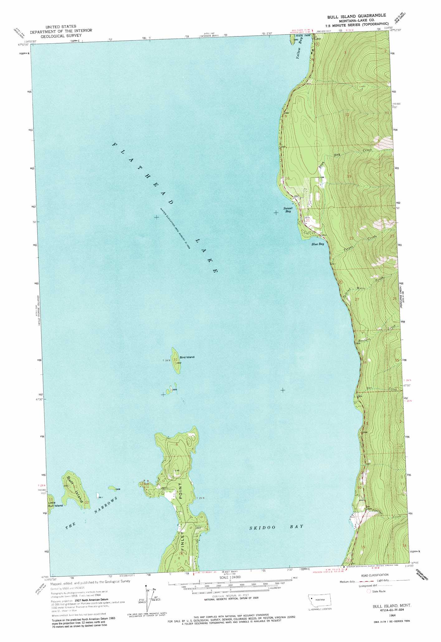
USGS Topo Quad 47114g1 - 1:24,000 scale
| Topo Map Name: | Bull Island |
| USGS Topo Quad ID: | 47114g1 |
| Print Size: | ca. 21 1/4" wide x 27" high |
| Southeast Coordinates: | 47.75° N latitude / 114° W longitude |
| Map Center Coordinates: | 47.8125° N latitude / 114.0625° W longitude |
| U.S. State: | MT |
| Filename: | o47114g1.jpg |
| Download Map JPG Image: | Bull Island topo map 1:24,000 scale |
| Map Type: | Topographic |
| Topo Series: | 7.5´ |
| Map Scale: | 1:24,000 |
| Source of Map Images: | United States Geological Survey (USGS) |
| Alternate Map Versions: |
Bull Island MT 1964, updated 1966 Download PDF Buy paper map Bull Island MT 1964, updated 1981 Download PDF Buy paper map Bull Island MT 1964, updated 1986 Download PDF Buy paper map Bull Island MT 2011 Download PDF Buy paper map Bull Island MT 2014 Download PDF Buy paper map |
1:24,000 Topo Quads surrounding Bull Island
Lion Mountain |
Somers |
Bigfork |
Crater Lake |
Big Hawk Mountain |
Proctor |
Rollins |
Woods Bay |
Yew Creek |
Swan Lake |
Elmo |
Wild Horse Island |
Bull Island |
Porcupine Creek |
Cilly Creek |
Buffalo Bridge |
Polson |
East Bay |
Cedar Lake |
Salmon Prairie |
Round Butte |
Lower Crow Reservoir |
Ronan |
Piper-Crow Pass |
Peck Lake |
> Back to 47114e1 at 1:100,000 scale
> Back to 47114a1 at 1:250,000 scale
> Back to U.S. Topo Maps home
Bull Island topo map: Gazetteer
Bull Island: Bays
Blue Bay elevation 883m 2896′Skidoo Bay elevation 883m 2896′
Sunset Bay elevation 883m 2896′
Yellow Bay elevation 883m 2896′
Bull Island: Capes
Finley Point elevation 893m 2929′Bull Island: Channels
The Narrows elevation 883m 2896′Bull Island: Islands
Bird Island elevation 897m 2942′Bull Island elevation 914m 2998′
Bull Island: Parks
Flathead Lake State Park - Finley Point Unit elevation 894m 2933′Bull Island: Streams
Blue Bay Creek elevation 889m 2916′Boulder Creek elevation 885m 2903′
Dee Creek elevation 883m 2896′
Station Creek elevation 883m 2896′
Talking Water Creek elevation 883m 2896′
Teepee Creek elevation 883m 2896′
Bull Island: Wells
23N19W07BAAA01 Well elevation 914m 2998′23N19W07BDAC01 Well elevation 910m 2985′
23N19W18ABB_01 Well elevation 890m 2919′
23N19W18BDAC01 Well elevation 887m 2910′
24N19W16DCA_01 Well elevation 913m 2995′
24N19W21ACAA01 Well elevation 906m 2972′
Bull Island digital topo map on disk
Buy this Bull Island topo map showing relief, roads, GPS coordinates and other geographical features, as a high-resolution digital map file on DVD: