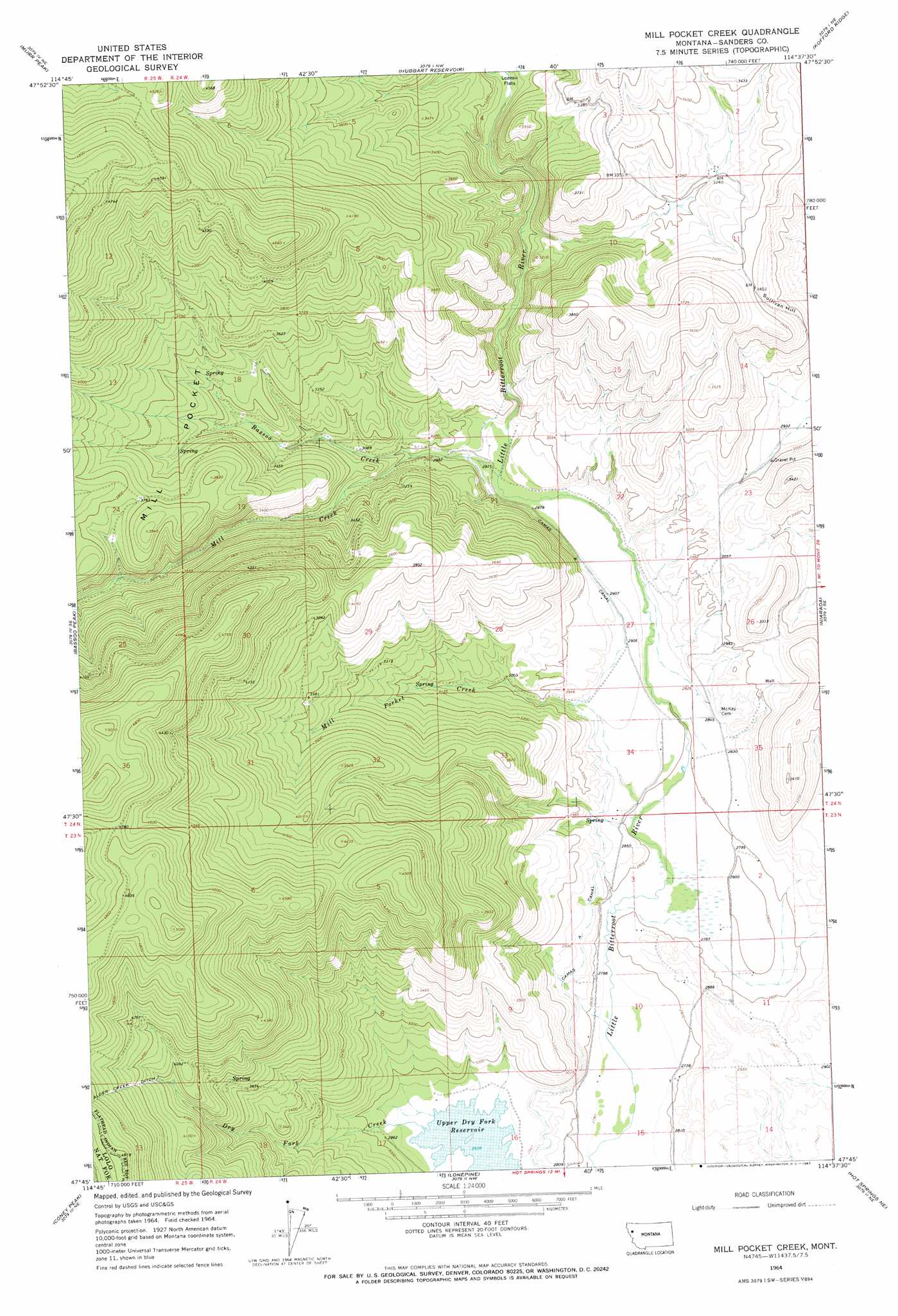
Mill Pocket Creek Topo Map Montana
To zoom in, hover over the map of Mill Pocket Creek
USGS Topo Quad 47114g6 - 1:24,000 scale
| Topo Map Name: | Mill Pocket Creek |
| USGS Topo Quad ID: | 47114g6 |
| Print Size: | ca. 21 1/4" wide x 27" high |
| Southeast Coordinates: | 47.75° N latitude / 114.625° W longitude |
| Map Center Coordinates: | 47.8125° N latitude / 114.6875° W longitude |
| U.S. State: | MT |
| Filename: | o47114g6.jpg |
| Download Map JPG Image: | Mill Pocket Creek topo map 1:24,000 scale |
| Map Type: | Topographic |
| Topo Series: | 7.5´ |
| Map Scale: | 1:24,000 |
| Source of Map Images: | United States Geological Survey (USGS) |
| Alternate Map Versions: |
Mill Pocket Creek MT 1964, updated 1967 Download PDF Buy paper map Mill Pocket Creek MT 1999, updated 2003 Download PDF Buy paper map Mill Pocket Creek MT 2011 Download PDF Buy paper map Mill Pocket Creek MT 2014 Download PDF Buy paper map |
| FStopo: | US Forest Service topo Mill Pocket Creek is available: Download FStopo PDF Download FStopo TIF |
1:24,000 Topo Quads surrounding Mill Pocket Creek
Meadow Peak |
Mcgregor Peak |
Marion |
Haskill Mountain |
Kila |
Shroder Creek |
Murr Peak |
Hubbart Reservoir |
Kofford Ridge |
Lake Mary Ronan |
Cook Mountain |
Bassoo Peak |
Mill Pocket Creek |
Niarada |
Irvine Lookout Tower |
Loneman Creek |
Coney Peak |
Lonepine |
Hot Springs Ne |
Irvine Hill |
Weeksville |
Baldy Lake |
Hot Springs |
Markle Pass |
Oliver Point |
> Back to 47114e1 at 1:100,000 scale
> Back to 47114a1 at 1:250,000 scale
> Back to U.S. Topo Maps home
Mill Pocket Creek topo map: Gazetteer
Mill Pocket Creek: Basins
Mill Pocket elevation 1065m 3494′Mill Pocket Creek: Canals
Camas A Canal elevation 885m 2903′Mill Pocket Creek: Flats
Lozeau Flats elevation 936m 3070′Mill Pocket Creek: Post Offices
Valleyview Post Office (historical) elevation 855m 2805′Mill Pocket Creek: Springs
23N24W03BAB_02 Spring elevation 870m 2854′Mill Pocket Creek: Streams
Bassoo Creek elevation 901m 2956′Dry Fork Creek elevation 894m 2933′
Mill Creek elevation 875m 2870′
Mill Pocket Creek elevation 851m 2791′
Mill Pocket Creek: Summits
Sullivan Hill elevation 962m 3156′Mill Pocket Creek: Wells
23N24W02CABA01 Well elevation 855m 2805′23N24W02CCD_01 Well elevation 853m 2798′
23N24W03BAB_01 Well elevation 870m 2854′
23N24W10ADA_01 Well elevation 874m 2867′
23N24W10BCDD01 Well elevation 852m 2795′
23N24W10CBC_01 Well elevation 860m 2821′
23N24W11CAC_01 Well elevation 892m 2926′
23N24W15AAA_01 Well elevation 883m 2896′
23N24W15BBA_01 Well elevation 849m 2785′
23N24W15CBC_01 Well elevation 894m 2933′
23N24W15CCBB01 Well elevation 854m 2801′
24N24W14DDD_01 Well elevation 884m 2900′
24N24W27BDBB01 Well elevation 892m 2926′
24N24W32DAA_01 Well elevation 1115m 3658′
Mill Pocket Creek digital topo map on disk
Buy this Mill Pocket Creek topo map showing relief, roads, GPS coordinates and other geographical features, as a high-resolution digital map file on DVD: