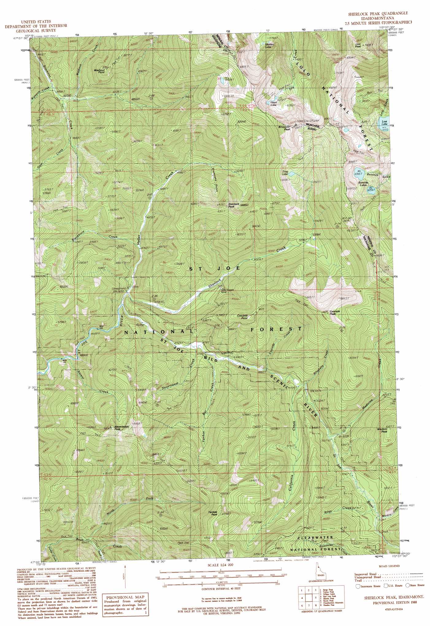
Sherlock Peak Topo Map Idaho
To zoom in, hover over the map of Sherlock Peak
USGS Topo Quad 47115a2 - 1:24,000 scale
| Topo Map Name: | Sherlock Peak |
| USGS Topo Quad ID: | 47115a2 |
| Print Size: | ca. 21 1/4" wide x 27" high |
| Southeast Coordinates: | 47° N latitude / 115.125° W longitude |
| Map Center Coordinates: | 47.0625° N latitude / 115.1875° W longitude |
| U.S. States: | ID, MT |
| Filename: | o47115a2.jpg |
| Download Map JPG Image: | Sherlock Peak topo map 1:24,000 scale |
| Map Type: | Topographic |
| Topo Series: | 7.5´ |
| Map Scale: | 1:24,000 |
| Source of Map Images: | United States Geological Survey (USGS) |
| Alternate Map Versions: |
Sherlock Peak ID 1988, updated 1988 Download PDF Buy paper map Sherlock Peak ID 1995, updated 1997 Download PDF Buy paper map Sherlock Peak ID 2011 Download PDF Buy paper map Sherlock Peak ID 2013 Download PDF Buy paper map |
| FStopo: | US Forest Service topo Sherlock Peak is available: Download FStopo PDF Download FStopo TIF |
1:24,000 Topo Quads surrounding Sherlock Peak
Mcgee Peak |
Deborgia South |
Boyd Mountain |
Saint Regis |
Keystone Peak |
Conrad Peak |
Berge Peak |
Torino Peak |
Wilson Gulch |
Superior |
Peggy Peak |
Red Ives Peak |
Sherlock Peak |
Illinois Peak |
Landowner Mountain |
Pole Mountain |
Bacon Peak |
Chamberlain Mountain |
Hoodoo Pass |
Straight Peak |
The Nub |
Elizabeth Lake |
Moose Mountain |
Osier Ridge |
Bruin Hill |
> Back to 47115a1 at 1:100,000 scale
> Back to 47114a1 at 1:250,000 scale
> Back to U.S. Topo Maps home
Sherlock Peak topo map: Gazetteer
Sherlock Peak: Lakes
Bonanza Lakes elevation 1921m 6302′Frog Lake elevation 1925m 6315′
Heart Lake elevation 1886m 6187′
Hidden Lake elevation 1743m 5718′
Lost Lake elevation 1837m 6026′
Sherlock Peak: Mines
Gold Nugget Mine elevation 1516m 4973′Sherlock Peak: Populated Places
McDonalds elevation 1550m 5085′Olsons elevation 1585m 5200′
Sherlock Peak: Ranges
Bitterroot Mountains elevation 2197m 7208′Sherlock Peak: Streams
Ascent Creek elevation 1397m 4583′Blackburn Creek elevation 1462m 4796′
Bluebells Creek elevation 1512m 4960′
California Creek elevation 1514m 4967′
Cascade Creek elevation 1488m 4881′
Dump Creek elevation 1344m 4409′
Goat Creek elevation 1436m 4711′
Heller Creek elevation 1431m 4694′
Medicine Creek elevation 1537m 5042′
Neversweat Creek elevation 1458m 4783′
North Fork Bean Creek elevation 1376m 4514′
Riley Creek elevation 1563m 5127′
Sherlock Creek elevation 1434m 4704′
Tinear Creek elevation 1403m 4603′
Wampus Creek elevation 1365m 4478′
Washout Creek elevation 1377m 4517′
Wisdom Creek elevation 1567m 5141′
Yankee Bar Creek elevation 1472m 4829′
Sherlock Peak: Summits
Binocular Peak elevation 2197m 7208′Cascade Peak elevation 2029m 6656′
Cascade Point elevation 1853m 6079′
Lost Peak elevation 2258m 7408′
Neversweat Peak elevation 2015m 6610′
Sherlock Peak elevation 1939m 6361′
Washout Point elevation 1749m 5738′
Wisdom Peak elevation 1880m 6167′
Yankee Peak elevation 2042m 6699′
Sherlock Peak: Valleys
Grubstake Gulch elevation 1598m 5242′Sherlock Peak digital topo map on disk
Buy this Sherlock Peak topo map showing relief, roads, GPS coordinates and other geographical features, as a high-resolution digital map file on DVD: