Montana Peak Topo Map Idaho
To zoom in, hover over the map of Montana Peak
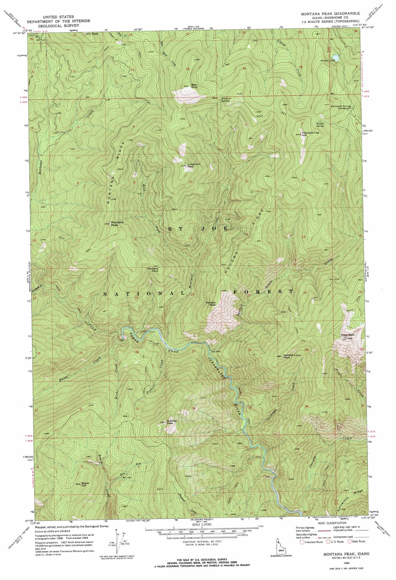
USGS Topo Quad 47115a6 - 1:24,000 scale
| Topo Map Name: | Montana Peak |
| USGS Topo Quad ID: | 47115a6 |
| Print Size: | ca. 21 1/4" wide x 27" high |
| Southeast Coordinates: | 47° N latitude / 115.625° W longitude |
| Map Center Coordinates: | 47.0625° N latitude / 115.6875° W longitude |
| U.S. State: | ID |
| Filename: | o47115a6.jpg |
| Download Map JPG Image: | Montana Peak topo map 1:24,000 scale |
| Map Type: | Topographic |
| Topo Series: | 7.5´ |
| Map Scale: | 1:24,000 |
| Source of Map Images: | United States Geological Survey (USGS) |
| Alternate Map Versions: |
Montana Peak ID 1969, updated 1973 Download PDF Buy paper map Montana Peak ID 1995, updated 1997 Download PDF Buy paper map Montana Peak ID 2011 Download PDF Buy paper map Montana Peak ID 2013 Download PDF Buy paper map |
| FStopo: | US Forest Service topo Montana Peak is available: Download FStopo PDF Download FStopo TIF |
1:24,000 Topo Quads surrounding Montana Peak
Mastodon Mountain |
Avery |
Shefoot Mountain |
Adair |
Mcgee Peak |
Hoyt Mountain |
Fishhook Creek |
Three Sisters |
Thor Mountain |
Conrad Peak |
Widow Mountain |
Monumental Buttes |
Montana Peak |
Bathtub Mountain |
Peggy Peak |
Pinchot Butte |
Little Goat Mountains |
Buzzard Roost |
Mallard Peak |
Pole Mountain |
Township Butte |
Bertha Hill |
Thompson Point |
Sheep Mountain |
The Nub |
> Back to 47115a1 at 1:100,000 scale
> Back to 47114a1 at 1:250,000 scale
> Back to U.S. Topo Maps home
Montana Peak topo map: Gazetteer
Montana Peak: Lakes
Dismal Lake elevation 1629m 5344′Montana Peak: Ridges
Hoodoo Ridge elevation 1688m 5538′Montana Ridge elevation 1769m 5803′
Surveyors Ridge elevation 1388m 4553′
Montana Peak: Springs
Hoodoo Spring elevation 1790m 5872′Montana Springs elevation 1779m 5836′
Montana Peak: Streams
Butte Creek elevation 976m 3202′Canyon Creek elevation 787m 2582′
Culdesac Creek elevation 849m 2785′
Durham Creek elevation 1054m 3458′
East Fork Brush Creek elevation 1217m 3992′
Mink Creek elevation 1017m 3336′
Montana Creek elevation 935m 3067′
Spotted Louis Creek elevation 911m 2988′
Stubtoe Creek elevation 933m 3061′
West Fork Montana Creek elevation 1080m 3543′
Montana Peak: Summits
Bear Skull elevation 1932m 6338′Brush Hill elevation 1529m 5016′
Hoodoo Peak elevation 1514m 4967′
Landmark Peak elevation 1892m 6207′
Montana Peak elevation 1767m 5797′
Montana Point elevation 1494m 4901′
Snow Peak elevation 2036m 6679′
Spotted Louis Point elevation 1728m 5669′
Stubtoe Peak elevation 1733m 5685′
Trimmed Tree Hill elevation 1943m 6374′
Montana Peak digital topo map on disk
Buy this Montana Peak topo map showing relief, roads, GPS coordinates and other geographical features, as a high-resolution digital map file on DVD: