Monumental Buttes Topo Map Idaho
To zoom in, hover over the map of Monumental Buttes
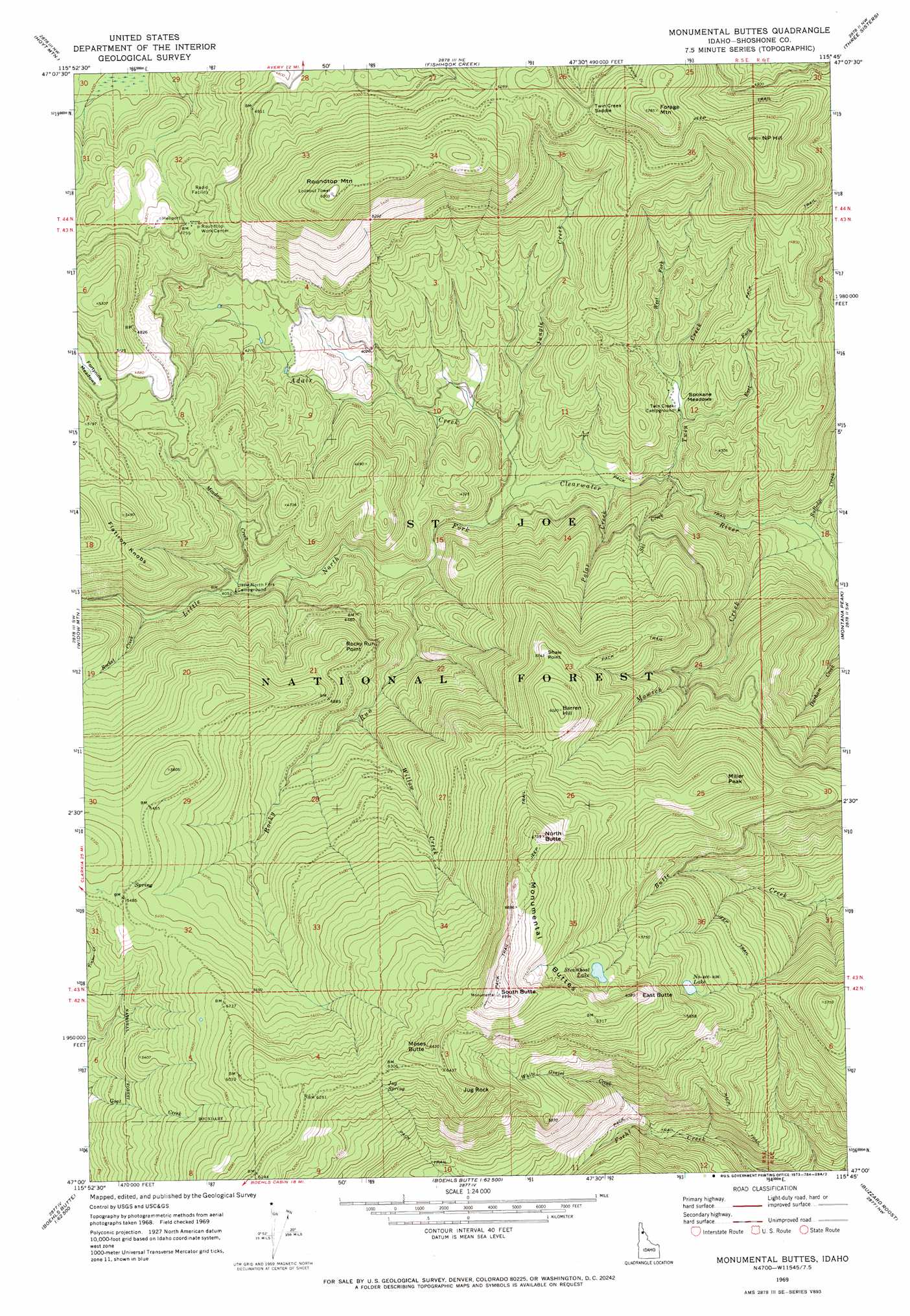
USGS Topo Quad 47115a7 - 1:24,000 scale
| Topo Map Name: | Monumental Buttes |
| USGS Topo Quad ID: | 47115a7 |
| Print Size: | ca. 21 1/4" wide x 27" high |
| Southeast Coordinates: | 47° N latitude / 115.75° W longitude |
| Map Center Coordinates: | 47.0625° N latitude / 115.8125° W longitude |
| U.S. State: | ID |
| Filename: | o47115a7.jpg |
| Download Map JPG Image: | Monumental Buttes topo map 1:24,000 scale |
| Map Type: | Topographic |
| Topo Series: | 7.5´ |
| Map Scale: | 1:24,000 |
| Source of Map Images: | United States Geological Survey (USGS) |
| Alternate Map Versions: |
Monumental Buttes ID 1969, updated 1973 Download PDF Buy paper map Monumental Buttes ID 1995, updated 1997 Download PDF Buy paper map Monumental Buttes ID 2011 Download PDF Buy paper map Monumental Buttes ID 2013 Download PDF Buy paper map |
| FStopo: | US Forest Service topo Monumental Buttes is available: Download FStopo PDF Download FStopo TIF |
1:24,000 Topo Quads surrounding Monumental Buttes
Marble Creek |
Mastodon Mountain |
Avery |
Shefoot Mountain |
Adair |
Marble Mountain |
Hoyt Mountain |
Fishhook Creek |
Three Sisters |
Thor Mountain |
Grandmother Mountain |
Widow Mountain |
Monumental Buttes |
Montana Peak |
Bathtub Mountain |
Grice Ridge |
Pinchot Butte |
Little Goat Mountains |
Buzzard Roost |
Mallard Peak |
Elk Butte |
Township Butte |
Bertha Hill |
Thompson Point |
Sheep Mountain |
> Back to 47115a1 at 1:100,000 scale
> Back to 47114a1 at 1:250,000 scale
> Back to U.S. Topo Maps home
Monumental Buttes topo map: Gazetteer
Monumental Buttes: Flats
Fortune Meadows elevation 1481m 4858′Spokane Meadows elevation 1155m 3789′
Monumental Buttes: Gaps
Twin Creek Saddle elevation 1609m 5278′Monumental Buttes: Lakes
Noseeum Lake elevation 1725m 5659′No-see-um Lake elevation 1680m 5511′
Steamboat Lake elevation 1800m 5905′
Monumental Buttes: Parks
Upper Fishook Research Natural Area elevation 1378m 4520′Monumental Buttes: Ridges
Monumental Buttes elevation 2079m 6820′Monumental Buttes: Springs
Jug Spring elevation 1894m 6213′Monumental Buttes: Streams
Adair Creek elevation 1130m 3707′East Fork Twin Creek elevation 1153m 3782′
Jungle Creek elevation 1139m 3736′
Meadow Creek elevation 1238m 4061′
Mowich Creek elevation 1056m 3464′
Polar Creek elevation 1107m 3631′
Rocket Creek elevation 1266m 4153′
Rocky Run elevation 1174m 3851′
Rutledge Creek elevation 1060m 3477′
Ski Creek elevation 1095m 3592′
Twin Creek elevation 1098m 3602′
West Fork Twin Creek elevation 1153m 3782′
White Gravel Creek elevation 1317m 4320′
Willow Creek elevation 1322m 4337′
Monumental Buttes: Summits
Barren Hill elevation 1834m 6017′East Butte elevation 1929m 6328′
Flatiron Knobs elevation 1675m 5495′
Forage Mountain elevation 1744m 5721′
Jug Rock elevation 1983m 6505′
Miller Peak elevation 1838m 6030′
Moses Butte elevation 2016m 6614′
N P Hill elevation 1732m 5682′
North Butte elevation 2023m 6637′
Rocky Run Point elevation 1537m 5042′
Roundtop Mountain elevation 1836m 6023′
Shale Point elevation 1732m 5682′
South Butte elevation 2126m 6975′
Monumental Buttes: Trails
Old Montana Trail (historical) elevation 1060m 3477′Monumental Buttes digital topo map on disk
Buy this Monumental Buttes topo map showing relief, roads, GPS coordinates and other geographical features, as a high-resolution digital map file on DVD: