Fishhook Creek Topo Map Idaho
To zoom in, hover over the map of Fishhook Creek
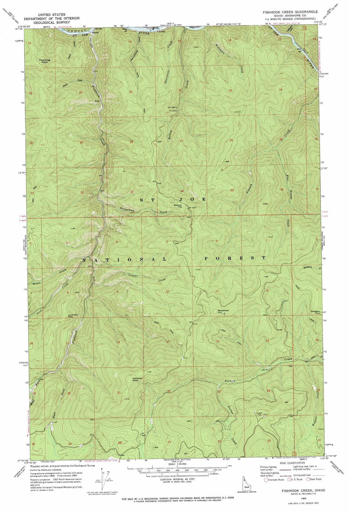
USGS Topo Quad 47115b7 - 1:24,000 scale
| Topo Map Name: | Fishhook Creek |
| USGS Topo Quad ID: | 47115b7 |
| Print Size: | ca. 21 1/4" wide x 27" high |
| Southeast Coordinates: | 47.125° N latitude / 115.75° W longitude |
| Map Center Coordinates: | 47.1875° N latitude / 115.8125° W longitude |
| U.S. State: | ID |
| Filename: | o47115b7.jpg |
| Download Map JPG Image: | Fishhook Creek topo map 1:24,000 scale |
| Map Type: | Topographic |
| Topo Series: | 7.5´ |
| Map Scale: | 1:24,000 |
| Source of Map Images: | United States Geological Survey (USGS) |
| Alternate Map Versions: |
Fishhook Creek ID 1969, updated 1973 Download PDF Buy paper map Fishhook Creek ID 1995, updated 1997 Download PDF Buy paper map Fishhook Creek ID 2011 Download PDF Buy paper map Fishhook Creek ID 2013 Download PDF Buy paper map |
| FStopo: | US Forest Service topo Fishhook Creek is available: Download FStopo PDF Download FStopo TIF |
1:24,000 Topo Quads surrounding Fishhook Creek
Polaris Peak |
Wallace |
Mullan |
Lookout Pass |
Saltese |
Marble Creek |
Mastodon Mountain |
Avery |
Shefoot Mountain |
Adair |
Marble Mountain |
Hoyt Mountain |
Fishhook Creek |
Three Sisters |
Thor Mountain |
Grandmother Mountain |
Widow Mountain |
Monumental Buttes |
Montana Peak |
Bathtub Mountain |
Grice Ridge |
Pinchot Butte |
Little Goat Mountains |
Buzzard Roost |
Mallard Peak |
> Back to 47115a1 at 1:100,000 scale
> Back to 47114a1 at 1:250,000 scale
> Back to U.S. Topo Maps home
Fishhook Creek topo map: Gazetteer
Fishhook Creek: Flats
Brebner Flat elevation 1393m 4570′Fishhook Creek: Streams
Blue Grouse Creek elevation 1021m 3349′Chute Creek elevation 777m 2549′
Coddington Creek elevation 769m 2522′
Cougar Creek elevation 938m 3077′
East Fork Fishhook Creek elevation 1068m 3503′
Fishhook Creek elevation 742m 2434′
Forage Creek elevation 1294m 4245′
Horsecamp Creek elevation 887m 2910′
Kelley Creek elevation 756m 2480′
Kelly Creek elevation 757m 2483′
Lick Creek elevation 913m 2995′
Outlaw Creek elevation 1112m 3648′
Wawa Creek elevation 922m 3024′
Webfoot Creek elevation 1211m 3973′
West Fork Fishhook Creek elevation 1068m 3503′
Williams Creek elevation 757m 2483′
Fishhook Creek: Summits
Bonehead Hill elevation 1652m 5419′Flemming Point elevation 1279m 4196′
Jacksons Knob elevation 1738m 5702′
Lick Creek Point elevation 1271m 4169′
Fishhook Creek: Valleys
Coddington Gulch elevation 769m 2522′Olson Gulch elevation 755m 2477′
Roundhouse Gulch elevation 765m 2509′
Fishhook Creek digital topo map on disk
Buy this Fishhook Creek topo map showing relief, roads, GPS coordinates and other geographical features, as a high-resolution digital map file on DVD: