Deborgia North Topo Map Montana
To zoom in, hover over the map of Deborgia North
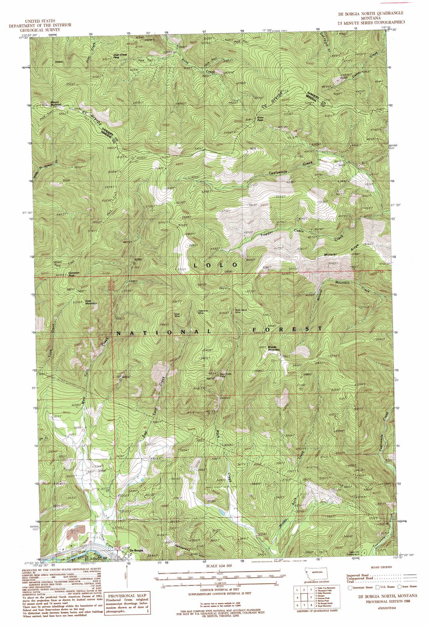
USGS Topo Quad 47115d3 - 1:24,000 scale
| Topo Map Name: | Deborgia North |
| USGS Topo Quad ID: | 47115d3 |
| Print Size: | ca. 21 1/4" wide x 27" high |
| Southeast Coordinates: | 47.375° N latitude / 115.25° W longitude |
| Map Center Coordinates: | 47.4375° N latitude / 115.3125° W longitude |
| U.S. State: | MT |
| Filename: | o47115d3.jpg |
| Download Map JPG Image: | Deborgia North topo map 1:24,000 scale |
| Map Type: | Topographic |
| Topo Series: | 7.5´ |
| Map Scale: | 1:24,000 |
| Source of Map Images: | United States Geological Survey (USGS) |
| Alternate Map Versions: |
De Borgia North MT 1988, updated 1988 Download PDF Buy paper map De Borgia North MT 1999, updated 2003 Download PDF Buy paper map De Borgia North MT 2011 Download PDF Buy paper map De Borgia North MT 2014 Download PDF Buy paper map |
| FStopo: | US Forest Service topo De Borgia North is available: Download FStopo PDF Download FStopo TIF |
1:24,000 Topo Quads surrounding Deborgia North
Helwick Peak |
Belknap |
Mount Headley |
Priscilla Peak |
Calico Creek |
Driveway Peak |
Table Top Mountain |
Thompson Falls |
Eddy Mountain |
Big Hole Peak |
Saltese |
Haugan |
Deborgia North |
Penrose Peak |
Sunset Peak |
Adair |
Mcgee Peak |
Deborgia South |
Boyd Mountain |
Saint Regis |
Thor Mountain |
Conrad Peak |
Berge Peak |
Torino Peak |
Wilson Gulch |
> Back to 47115a1 at 1:100,000 scale
> Back to 47114a1 at 1:250,000 scale
> Back to U.S. Topo Maps home
Deborgia North topo map: Gazetteer
Deborgia North: Crossings
Interchange 18 elevation 938m 3077′Deborgia North: Gaps
Joan Creek Pass elevation 1400m 4593′Knox Pass elevation 1577m 5173′
Deborgia North: Mines
Copper Rock Mine elevation 1694m 5557′Copper Rock Mine elevation 1724m 5656′
Rock Island Mine elevation 1575m 5167′
Rock Island Mine elevation 1559m 5114′
Texas Mine elevation 1684m 5524′
Texas Mine elevation 1647m 5403′
True Fissure Mine elevation 1358m 4455′
True Fissure Mine elevation 1322m 4337′
Upper West Twin Creek Mine elevation 1475m 4839′
Valentine Mine elevation 1714m 5623′
Valentine Mine elevation 1681m 5515′
West Twin Creek Mine elevation 1189m 3900′
Deborgia North: Populated Places
De Borgia elevation 936m 3070′Deborgia North: Post Offices
De Borgia Post Office (historical) elevation 936m 3070′Deborgia North: Ridges
Mineral Ridge elevation 1567m 5141′Deborgia North: Streams
Deer Creek elevation 937m 3074′Dry Creek elevation 1100m 3608′
East Twin Creek elevation 941m 3087′
Middle Rock Creek elevation 967m 3172′
Trapper Cabin Creek elevation 1235m 4051′
Deborgia North: Summits
Brooks Mountain elevation 1737m 5698′Cameron Peak elevation 1848m 6062′
Goat Mountain elevation 1809m 5935′
Henderson Hill elevation 1248m 4094′
Mount Bushnell elevation 1808m 5931′
Rock Creek Vista elevation 1498m 4914′
Deborgia North digital topo map on disk
Buy this Deborgia North topo map showing relief, roads, GPS coordinates and other geographical features, as a high-resolution digital map file on DVD: