Priscilla Peak Topo Map Montana
To zoom in, hover over the map of Priscilla Peak
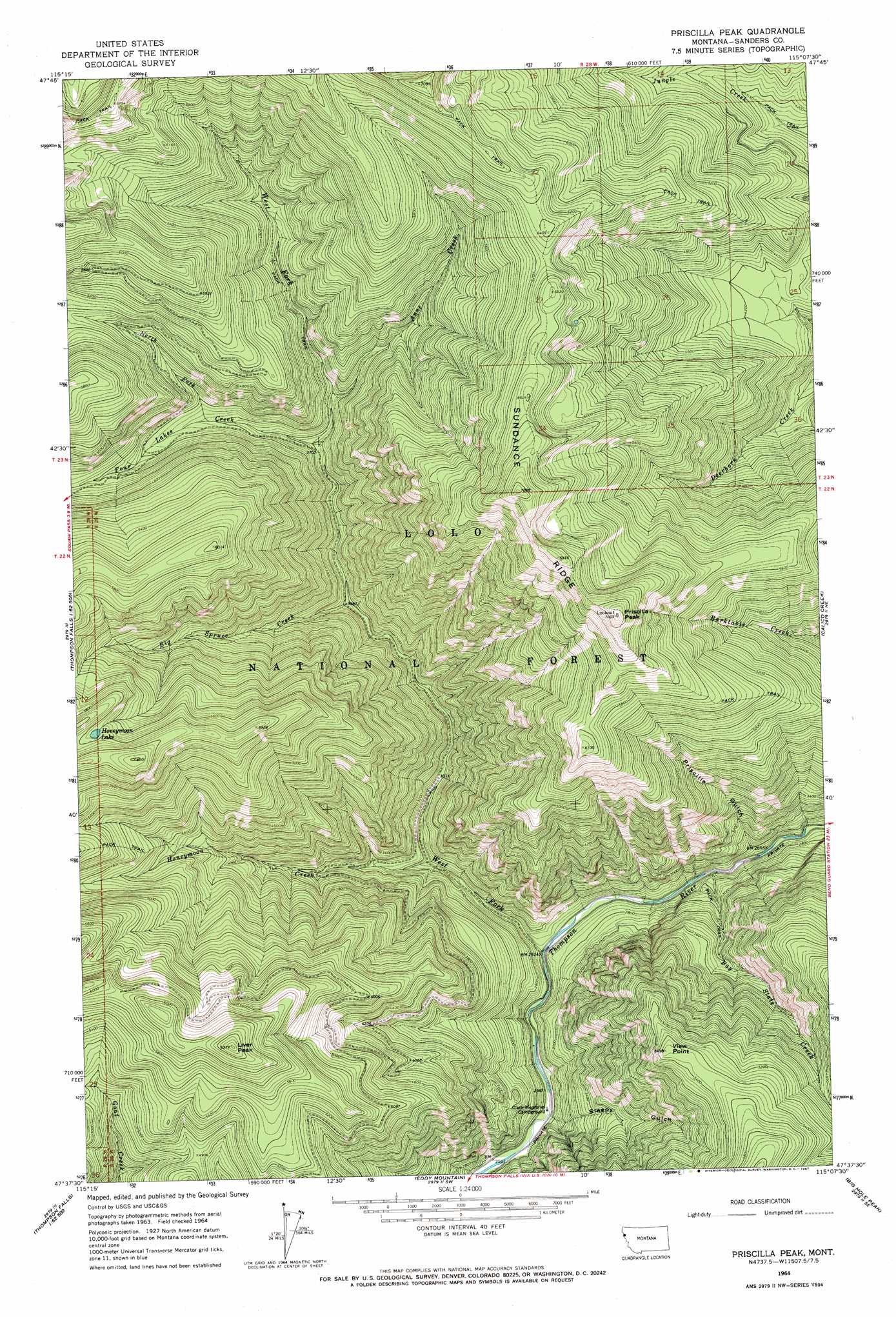
USGS Topo Quad 47115f2 - 1:24,000 scale
| Topo Map Name: | Priscilla Peak |
| USGS Topo Quad ID: | 47115f2 |
| Print Size: | ca. 21 1/4" wide x 27" high |
| Southeast Coordinates: | 47.625° N latitude / 115.125° W longitude |
| Map Center Coordinates: | 47.6875° N latitude / 115.1875° W longitude |
| U.S. State: | MT |
| Filename: | o47115f2.jpg |
| Download Map JPG Image: | Priscilla Peak topo map 1:24,000 scale |
| Map Type: | Topographic |
| Topo Series: | 7.5´ |
| Map Scale: | 1:24,000 |
| Source of Map Images: | United States Geological Survey (USGS) |
| Alternate Map Versions: |
Priscilla Peak MT 1964, updated 1967 Download PDF Buy paper map Priscilla Peak MT 1999, updated 2003 Download PDF Buy paper map Priscilla Peak MT 2011 Download PDF Buy paper map Priscilla Peak MT 2014 Download PDF Buy paper map |
| FStopo: | US Forest Service topo Priscilla Peak is available: Download FStopo PDF Download FStopo TIF |
1:24,000 Topo Quads surrounding Priscilla Peak
Silver Butte Pass |
Miller Lake |
Mantrap Fork |
Bend |
Shroder Creek |
Seven Point Mountain |
Vermilion Peak |
Fishtrap Lake |
Richards Peak |
Cook Mountain |
Belknap |
Mount Headley |
Priscilla Peak |
Calico Creek |
Loneman Creek |
Table Top Mountain |
Thompson Falls |
Eddy Mountain |
Big Hole Peak |
Weeksville |
Haugan |
Deborgia North |
Penrose Peak |
Sunset Peak |
Plains |
> Back to 47115e1 at 1:100,000 scale
> Back to 47114a1 at 1:250,000 scale
> Back to U.S. Topo Maps home
Priscilla Peak topo map: Gazetteer
Priscilla Peak: Lakes
Honeymoon Lake elevation 1752m 5748′Priscilla Peak: Ridges
Sundance Ridge elevation 2162m 7093′Priscilla Peak: Streams
Anne Creek elevation 1188m 3897′Bay State Creek elevation 805m 2641′
Big Spruce Creek elevation 1030m 3379′
Four Lakes Creek elevation 1124m 3687′
Honeymoon Creek elevation 879m 2883′
North Fork Four Lakes Creek elevation 1229m 4032′
West Fork Thompson River elevation 793m 2601′
Priscilla Peak: Summits
Liver Peak elevation 1932m 6338′Priscilla Peak elevation 2132m 6994′
View Point elevation 1675m 5495′
Priscilla Peak: Valleys
Priscilla Gulch elevation 812m 2664′Sleepy Gulch elevation 789m 2588′
Priscilla Peak digital topo map on disk
Buy this Priscilla Peak topo map showing relief, roads, GPS coordinates and other geographical features, as a high-resolution digital map file on DVD: