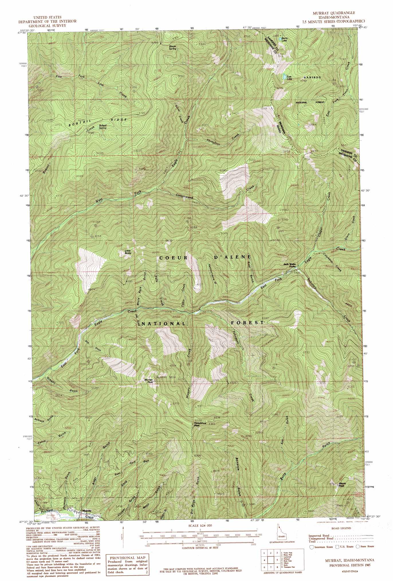
Murray Topo Map Idaho
To zoom in, hover over the map of Murray
USGS Topo Quad 47115f7 - 1:24,000 scale
| Topo Map Name: | Murray |
| USGS Topo Quad ID: | 47115f7 |
| Print Size: | ca. 21 1/4" wide x 27" high |
| Southeast Coordinates: | 47.625° N latitude / 115.75° W longitude |
| Map Center Coordinates: | 47.6875° N latitude / 115.8125° W longitude |
| U.S. States: | ID, MT |
| Filename: | o47115f7.jpg |
| Download Map JPG Image: | Murray topo map 1:24,000 scale |
| Map Type: | Topographic |
| Topo Series: | 7.5´ |
| Map Scale: | 1:24,000 |
| Source of Map Images: | United States Geological Survey (USGS) |
| Alternate Map Versions: |
Murray ID 1985, updated 1985 Download PDF Buy paper map Murray ID 1996, updated 1999 Download PDF Buy paper map Murray ID 2011 Download PDF Buy paper map Murray ID 2013 Download PDF Buy paper map |
| FStopo: | US Forest Service topo Murray is available: Download FStopo PDF Download FStopo TIF |
1:24,000 Topo Quads surrounding Murray
Jordan Creek |
Gem Peak |
Noxon |
Noxon Rapids Dam |
Goat Peak |
Pond Peak |
Taylor Peak |
Bloom Peak |
Larchwood |
Trout Creek |
Grizzly Mountain |
Prichard |
Murray |
Black Peak |
Helwick Peak |
Kellogg East |
Osburn |
Burke |
Thompson Pass |
Driveway Peak |
Polaris Peak |
Wallace |
Mullan |
Lookout Pass |
Saltese |
> Back to 47115e1 at 1:100,000 scale
> Back to 47114a1 at 1:250,000 scale
> Back to U.S. Topo Maps home
Murray topo map: Gazetteer
Murray: Lakes
Berry Lake elevation 1669m 5475′East Lake elevation 1706m 5597′
Murray: Populated Places
Murray elevation 845m 2772′Murray: Ridges
Bobtail Ridge elevation 1408m 4619′Murray: Springs
Bloom Spring elevation 1477m 4845′Murray: Streams
34 Creek elevation 1059m 3474′Bobtail Creek elevation 893m 2929′
Cabin Creek elevation 935m 3067′
Casper Creek elevation 1073m 3520′
Columbus Creek elevation 1071m 3513′
Cottonwood Creek elevation 997m 3270′
Falls Creek elevation 921m 3021′
Niagara Creek elevation 937m 3074′
Silent Creek elevation 1104m 3622′
Silver Creek elevation 1104m 3622′
Snowshoe Creek elevation 1151m 3776′
Toboggan Creek elevation 950m 3116′
Tributary Creek elevation 1039m 3408′
Murray: Summits
Dons Mountain elevation 1823m 5980′Horseshoe Peak elevation 1732m 5682′
Johns Mountain elevation 1866m 6122′
Little Baldy elevation 1691m 5547′
Maple Peak elevation 1718m 5636′
Murray Peak elevation 1823m 5980′
Murray: Valleys
Alder Gulch elevation 857m 2811′Axe Gulch elevation 1086m 3562′
Bonanza Gulch elevation 991m 3251′
Buckskin Gulch elevation 843m 2765′
Dream Gulch elevation 826m 2709′
East Fork Alder Gulch elevation 952m 3123′
Goat Gulch elevation 994m 3261′
Log Gulch elevation 958m 3143′
Oregon Gulch elevation 857m 2811′
Pennsylvania Gulch elevation 976m 3202′
Saw Gulch elevation 900m 2952′
White Rock Gulch elevation 911m 2988′
Murray digital topo map on disk
Buy this Murray topo map showing relief, roads, GPS coordinates and other geographical features, as a high-resolution digital map file on DVD: