Noxon Rapids Dam Topo Map Montana
To zoom in, hover over the map of Noxon Rapids Dam
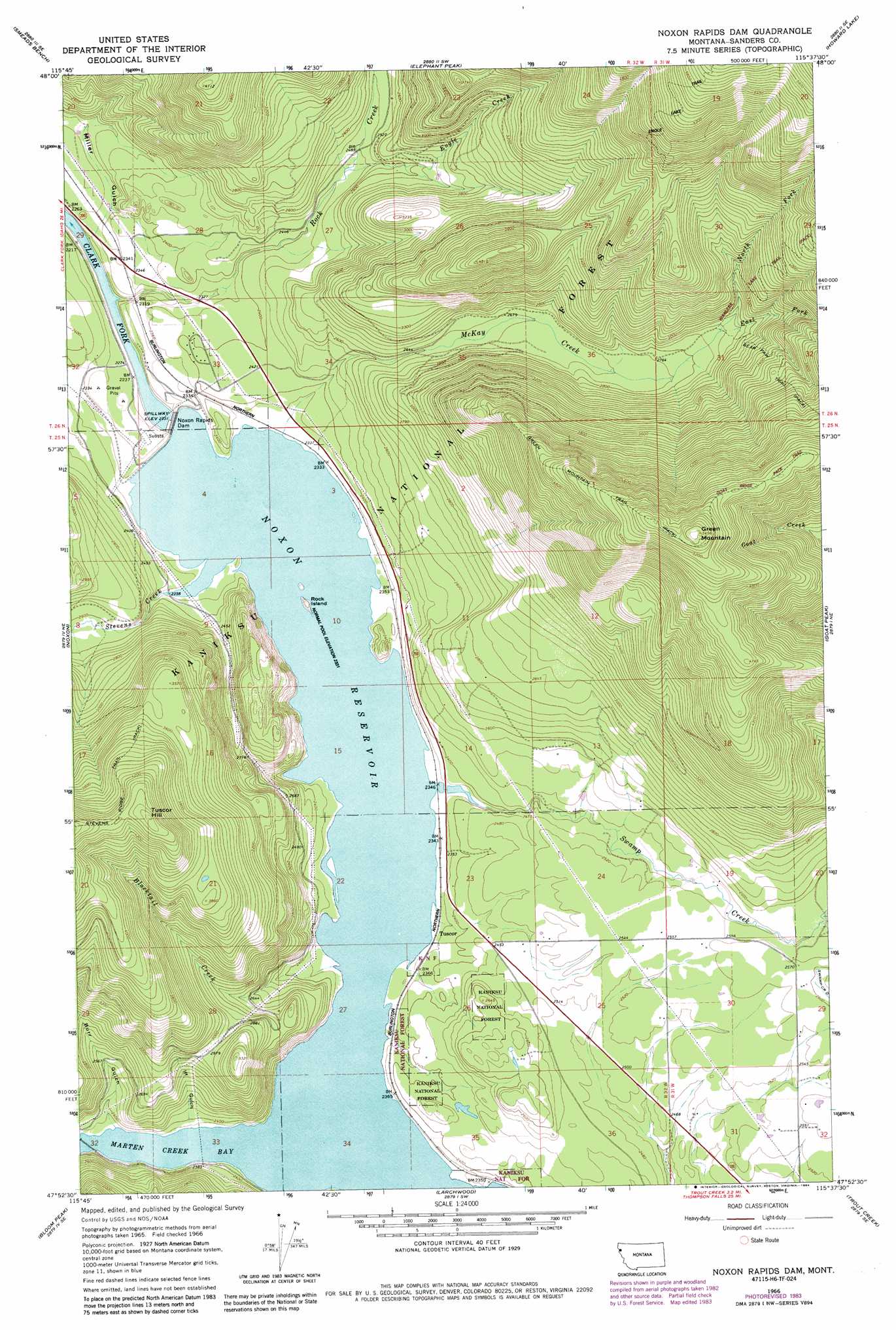
USGS Topo Quad 47115h6 - 1:24,000 scale
| Topo Map Name: | Noxon Rapids Dam |
| USGS Topo Quad ID: | 47115h6 |
| Print Size: | ca. 21 1/4" wide x 27" high |
| Southeast Coordinates: | 47.875° N latitude / 115.625° W longitude |
| Map Center Coordinates: | 47.9375° N latitude / 115.6875° W longitude |
| U.S. State: | MT |
| Filename: | o47115h6.jpg |
| Download Map JPG Image: | Noxon Rapids Dam topo map 1:24,000 scale |
| Map Type: | Topographic |
| Topo Series: | 7.5´ |
| Map Scale: | 1:24,000 |
| Source of Map Images: | United States Geological Survey (USGS) |
| Alternate Map Versions: |
Noxon Rapids Dam MT 1966, updated 1970 Download PDF Buy paper map Noxon Rapids Dam MT 1966, updated 1984 Download PDF Buy paper map Noxon Rapids Dam MT 1997, updated 2000 Download PDF Buy paper map Noxon Rapids Dam MT 2011 Download PDF Buy paper map Noxon Rapids Dam MT 2014 Download PDF Buy paper map |
| FStopo: | US Forest Service topo Noxon Rapids Dam is available: Download FStopo PDF Download FStopo TIF |
1:24,000 Topo Quads surrounding Noxon Rapids Dam
Sawtooth Mountain |
Ibex Peak |
Snowshoe Peak |
Cable Mountain |
Horse Mountain |
Heron |
Smeads Bench |
Elephant Peak |
Howard Lake |
Barren Peak |
Gem Peak |
Noxon |
Noxon Rapids Dam |
Goat Peak |
Silver Butte Pass |
Taylor Peak |
Bloom Peak |
Larchwood |
Trout Creek |
Seven Point Mountain |
Prichard |
Murray |
Black Peak |
Helwick Peak |
Belknap |
> Back to 47115e1 at 1:100,000 scale
> Back to 47114a1 at 1:250,000 scale
> Back to U.S. Topo Maps home
Noxon Rapids Dam topo map: Gazetteer
Noxon Rapids Dam: Bays
Marten Creek Bay elevation 712m 2335′Noxon Rapids Dam: Canals
Swamp Creek Ditch elevation 796m 2611′Noxon Rapids Dam: Dams
Noxon Rapids Dam elevation 704m 2309′Noxon Rapids Dam elevation 690m 2263′
Noxon Rapids Dam: Islands
Rock Island elevation 712m 2335′Noxon Rapids Dam: Populated Places
Tuscor elevation 720m 2362′Noxon Rapids Dam: Post Offices
Tuscor Post Office (historical) elevation 712m 2335′Noxon Rapids Dam: Reservoirs
Noxon Rapids Reservoir elevation 690m 2263′Noxon Reservoir elevation 709m 2326′
Noxon Rapids Dam: Streams
Blacktail Creek elevation 712m 2335′East Fork McKay Creek elevation 877m 2877′
Engle Creek elevation 748m 2454′
McKay Creek elevation 712m 2335′
North Fork McKay Creek elevation 877m 2877′
Rock Creek elevation 668m 2191′
Stevens Creek elevation 712m 2335′
Swamp Creek elevation 712m 2335′
Noxon Rapids Dam: Summits
Green Mountain elevation 1661m 5449′Tuscor Hill elevation 1377m 4517′
Noxon Rapids Dam: Trails
Bear Paw Trail elevation 1108m 3635′Engle Lake Trail elevation 1250m 4101′
Green Mountain Trail elevation 1443m 4734′
Noxon Rapids Dam: Valleys
Burr Gulch elevation 712m 2335′Iff Gulch elevation 720m 2362′
Miller Gulch elevation 675m 2214′
Noxon Rapids Dam: Wells
25N31W30DADD01 Well elevation 783m 2568′25N32W03BAAB01 Well elevation 722m 2368′
25N32W23ACAB01 Well elevation 744m 2440′
Noxon Rapids Dam digital topo map on disk
Buy this Noxon Rapids Dam topo map showing relief, roads, GPS coordinates and other geographical features, as a high-resolution digital map file on DVD: