Huckleberry Mountain Topo Map Idaho
To zoom in, hover over the map of Huckleberry Mountain
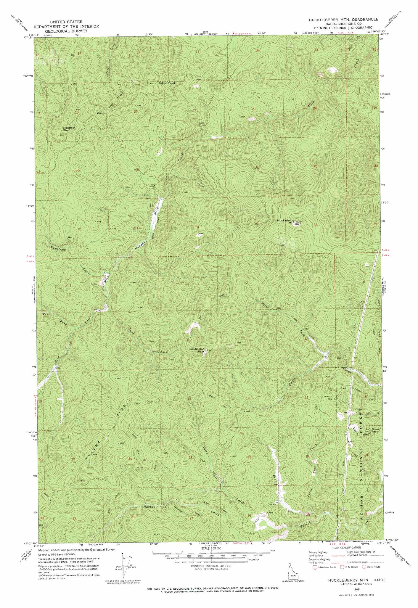
USGS Topo Quad 47116b2 - 1:24,000 scale
| Topo Map Name: | Huckleberry Mountain |
| USGS Topo Quad ID: | 47116b2 |
| Print Size: | ca. 21 1/4" wide x 27" high |
| Southeast Coordinates: | 47.125° N latitude / 116.125° W longitude |
| Map Center Coordinates: | 47.1875° N latitude / 116.1875° W longitude |
| U.S. State: | ID |
| Filename: | o47116b2.jpg |
| Download Map JPG Image: | Huckleberry Mountain topo map 1:24,000 scale |
| Map Type: | Topographic |
| Topo Series: | 7.5´ |
| Map Scale: | 1:24,000 |
| Source of Map Images: | United States Geological Survey (USGS) |
| Alternate Map Versions: |
Huckleberry Mtn ID 1969, updated 1973 Download PDF Buy paper map Huckleberry Mountain ID 1995, updated 1997 Download PDF Buy paper map Huckleberry Mountain ID 2011 Download PDF Buy paper map Huckleberry Mountain ID 2013 Download PDF Buy paper map |
| FStopo: | US Forest Service topo Huckleberry Mountain is available: Download FStopo PDF Download FStopo TIF |
1:24,000 Topo Quads surrounding Huckleberry Mountain
Rochat Peak |
Twin Crags |
Masonia |
Polaris Peak |
Wallace |
Saint Joe Baldy |
Saint Joe |
Calder |
Marble Creek |
Mastodon Mountain |
Santa |
Crystal Peak |
Huckleberry Mountain |
Marble Mountain |
Hoyt Mountain |
Fernwood |
Clarkia |
Merry Creek |
Grandmother Mountain |
Widow Mountain |
Abes Knob |
Bechtel Butte |
Anthony Peak |
Grice Ridge |
Pinchot Butte |
> Back to 47116a1 at 1:100,000 scale
> Back to 47116a1 at 1:250,000 scale
> Back to U.S. Topo Maps home
Huckleberry Mountain topo map: Gazetteer
Huckleberry Mountain: Flats
Mica Meadows elevation 944m 3097′Huckleberry Mountain: Ridges
Tylers Ridge elevation 1556m 5104′Huckleberry Mountain: Streams
Bear Creek elevation 1020m 3346′East Fork Mica Creek elevation 984m 3228′
Engstrom Creek elevation 953m 3126′
Little Bear Creek elevation 1031m 3382′
North Fork Eagle Creek elevation 1055m 3461′
Toles Creek elevation 1046m 3431′
West Fork Mica Creek elevation 1006m 3300′
Huckleberry Mountain: Summits
Bussel Peak elevation 1355m 4445′Calder Point elevation 1310m 4297′
Coddington Peak elevation 1409m 4622′
Evergreen Mountain elevation 1341m 4399′
Huckleberry Mountain elevation 1712m 5616′
Huckleberry Mountain digital topo map on disk
Buy this Huckleberry Mountain topo map showing relief, roads, GPS coordinates and other geographical features, as a high-resolution digital map file on DVD: