Rose Lake Topo Map Idaho
To zoom in, hover over the map of Rose Lake
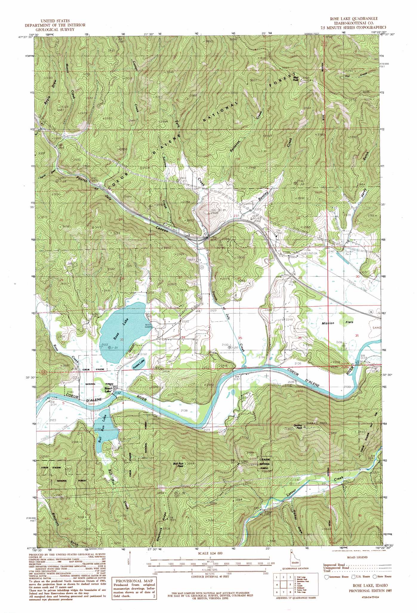
USGS Topo Quad 47116e4 - 1:24,000 scale
| Topo Map Name: | Rose Lake |
| USGS Topo Quad ID: | 47116e4 |
| Print Size: | ca. 21 1/4" wide x 27" high |
| Southeast Coordinates: | 47.5° N latitude / 116.375° W longitude |
| Map Center Coordinates: | 47.5625° N latitude / 116.4375° W longitude |
| U.S. State: | ID |
| Filename: | o47116e4.jpg |
| Download Map JPG Image: | Rose Lake topo map 1:24,000 scale |
| Map Type: | Topographic |
| Topo Series: | 7.5´ |
| Map Scale: | 1:24,000 |
| Source of Map Images: | United States Geological Survey (USGS) |
| Alternate Map Versions: |
Rose Lake ID 1985, updated 1985 Download PDF Buy paper map Rose Lake ID 1996, updated 1999 Download PDF Buy paper map Rose Lake ID 2011 Download PDF Buy paper map Rose Lake ID 2013 Download PDF Buy paper map |
| FStopo: | US Forest Service topo Rose Lake is available: Download FStopo PDF Download FStopo TIF |
1:24,000 Topo Quads surrounding Rose Lake
Hayden Lake |
Spades Mountain |
Cataract Peak |
Lamb Peak |
Spyglass Peak |
Fernan Lake |
Wolf Lodge |
Skitwish Peak |
Bumblebee Peak |
Steamboat Creek |
Mount Coeur D'Alene |
Lane |
Rose Lake |
Cataldo |
Kellogg West |
Black Lake |
Medimont |
Rochat Peak |
Twin Crags |
Masonia |
Benewah Lake |
Saint Maries |
Saint Joe Baldy |
Saint Joe |
Calder |
> Back to 47116e1 at 1:100,000 scale
> Back to 47116a1 at 1:250,000 scale
> Back to U.S. Topo Maps home
Rose Lake topo map: Gazetteer
Rose Lake: Flats
Mission Flats elevation 654m 2145′Rose Lake: Lakes
Porters lake elevation 653m 2142′Rose Lake elevation 653m 2142′
Rose Lake: Populated Places
Canyon elevation 678m 2224′Dudley elevation 650m 2132′
Rose Lake elevation 655m 2148′
Rose Lake: Rapids
Hnselut (historical) elevation 658m 2158′Rose Lake: Streams
Bentley Creek elevation 653m 2142′Bull Run Creek elevation 652m 2139′
Curran Creek elevation 692m 2270′
Fern Creek elevation 667m 2188′
Fourth of July Creek elevation 650m 2132′
Little Baldy Creek elevation 679m 2227′
Mason Creek elevation 745m 2444′
Mill Creek elevation 765m 2509′
Rantenan Creek elevation 683m 2240′
Rose Creek elevation 652m 2139′
Service Creek elevation 671m 2201′
Rose Lake: Summits
Bull Run Peak elevation 1202m 3943′Dudley Peak elevation 1198m 3930′
Wall Peak elevation 1250m 4101′
Rose Lake: Valleys
Bogle Draw elevation 775m 2542′Fourth of July Canyon elevation 653m 2142′
Hardy Gulch elevation 672m 2204′
Higbee Draw elevation 717m 2352′
Terrill Draw elevation 730m 2395′
Rose Lake digital topo map on disk
Buy this Rose Lake topo map showing relief, roads, GPS coordinates and other geographical features, as a high-resolution digital map file on DVD: