Mica Bay Topo Map Idaho
To zoom in, hover over the map of Mica Bay
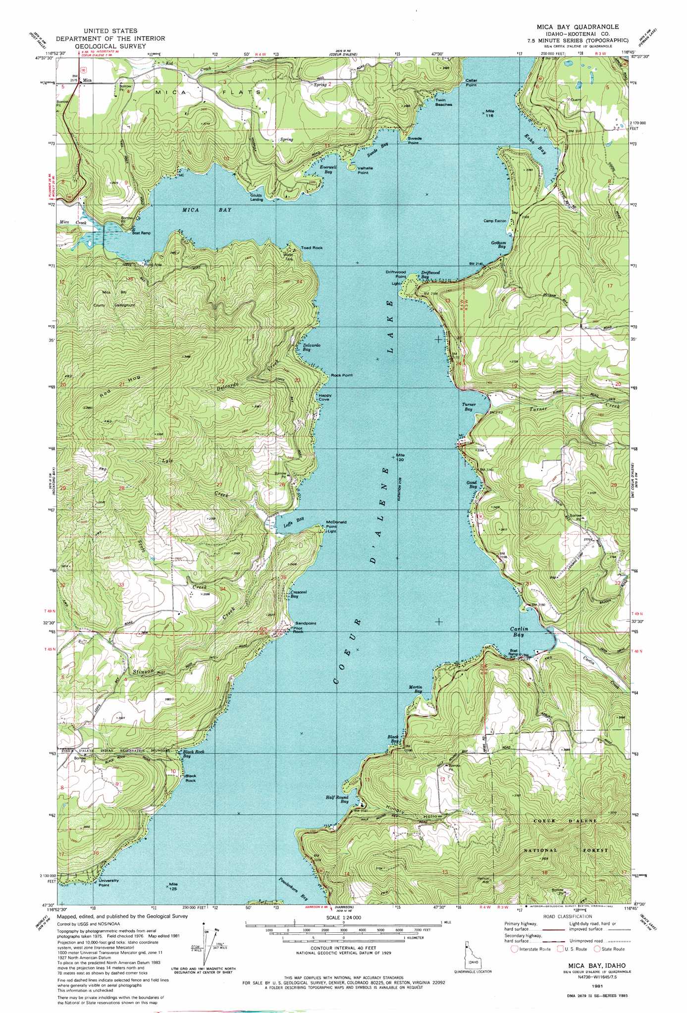
USGS Topo Quad 47116e7 - 1:24,000 scale
| Topo Map Name: | Mica Bay |
| USGS Topo Quad ID: | 47116e7 |
| Print Size: | ca. 21 1/4" wide x 27" high |
| Southeast Coordinates: | 47.5° N latitude / 116.75° W longitude |
| Map Center Coordinates: | 47.5625° N latitude / 116.8125° W longitude |
| U.S. State: | ID |
| Filename: | o47116e7.jpg |
| Download Map JPG Image: | Mica Bay topo map 1:24,000 scale |
| Map Type: | Topographic |
| Topo Series: | 7.5´ |
| Map Scale: | 1:24,000 |
| Source of Map Images: | United States Geological Survey (USGS) |
| Alternate Map Versions: |
Coeur D'Alene SE ID 1975, updated 1977 Download PDF Buy paper map Mica Bay ID 1981, updated 1982 Download PDF Buy paper map Mica Bay ID 1996, updated 1999 Download PDF Buy paper map Mica Bay ID 2011 Download PDF Buy paper map Mica Bay ID 2013 Download PDF Buy paper map |
| FStopo: | US Forest Service topo Mica Bay is available: Download FStopo PDF Download FStopo TIF |
1:24,000 Topo Quads surrounding Mica Bay
Newman Lake |
Rathdrum |
Hayden |
Hayden Lake |
Spades Mountain |
Liberty Lake |
Post Falls |
Coeur D'Alene |
Fernan Lake |
Wolf Lodge |
Mica Peak |
Rockford Bay |
Mica Bay |
Mount Coeur D'Alene |
Lane |
Setters |
Worley |
Harrison |
Black Lake |
Medimont |
Tekoa Mountain |
Plummer |
Chatcolet |
Benewah Lake |
Saint Maries |
> Back to 47116e1 at 1:100,000 scale
> Back to 47116a1 at 1:250,000 scale
> Back to U.S. Topo Maps home
Mica Bay topo map: Gazetteer
Mica Bay: Bays
Black Bay elevation 649m 2129′Black Rock Bay elevation 649m 2129′
Carlin Bay elevation 649m 2129′
Crescent Bay elevation 649m 2129′
Driftwood Bay elevation 649m 2129′
Echo Bay elevation 649m 2129′
Everwell Bay elevation 649m 2129′
Gand Bay elevation 649m 2129′
Gotham Bay elevation 649m 2129′
Half Round Bay elevation 649m 2129′
Happy Cove elevation 649m 2129′
Loffs Bay elevation 649m 2129′
Martin Bay elevation 649m 2129′
Mica Bay elevation 649m 2129′
Swede Bay elevation 649m 2129′
Turner Bay elevation 649m 2129′
Mica Bay: Capes
Black Rock elevation 659m 2162′Cellar Point elevation 682m 2237′
Delcardo Bay elevation 649m 2129′
Driftwood Point elevation 654m 2145′
Lyndale Landing elevation 666m 2185′
McDonald Point elevation 658m 2158′
Pilot Rock Sandpoint elevation 667m 2188′
Pugh Point elevation 665m 2181′
Swede Point elevation 660m 2165′
University Point elevation 660m 2165′
Valhalla Point elevation 665m 2181′
Mica Bay: Pillars
Toad Rock elevation 649m 2129′Mica Bay: Populated Places
Len Landing elevation 661m 2168′Lyondale (historical) elevation 666m 2185′
Mica elevation 788m 2585′
Twin Beaches elevation 679m 2227′
Mica Bay: Ridges
Red Hog elevation 1161m 3809′Mica Bay: Streams
Carlin Creek elevation 649m 2129′Delcardo Creek elevation 649m 2129′
Lyle Creek elevation 651m 2135′
Mica Creek elevation 649m 2129′
Scott Creek elevation 670m 2198′
Stinson Creek elevation 659m 2162′
Turner Creek elevation 649m 2129′
Mica Bay: Valleys
Hungry Hollow elevation 650m 2132′Mica Bay digital topo map on disk
Buy this Mica Bay topo map showing relief, roads, GPS coordinates and other geographical features, as a high-resolution digital map file on DVD: