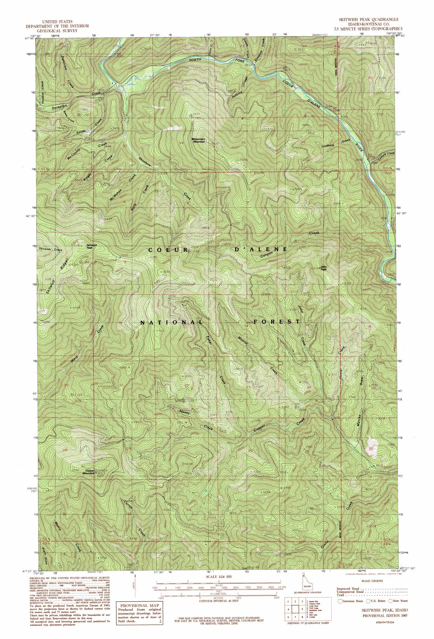
Skitwish Peak Topo Map Idaho
To zoom in, hover over the map of Skitwish Peak
USGS Topo Quad 47116f4 - 1:24,000 scale
| Topo Map Name: | Skitwish Peak |
| USGS Topo Quad ID: | 47116f4 |
| Print Size: | ca. 21 1/4" wide x 27" high |
| Southeast Coordinates: | 47.625° N latitude / 116.375° W longitude |
| Map Center Coordinates: | 47.6875° N latitude / 116.4375° W longitude |
| U.S. State: | ID |
| Filename: | o47116f4.jpg |
| Download Map JPG Image: | Skitwish Peak topo map 1:24,000 scale |
| Map Type: | Topographic |
| Topo Series: | 7.5´ |
| Map Scale: | 1:24,000 |
| Source of Map Images: | United States Geological Survey (USGS) |
| Alternate Map Versions: |
Skitwish Peak ID 1985, updated 1985 Download PDF Buy paper map Skitwish Peak ID 1996, updated 1999 Download PDF Buy paper map Skitwish Peak ID 2011 Download PDF Buy paper map Skitwish Peak ID 2013 Download PDF Buy paper map |
| FStopo: | US Forest Service topo Skitwish Peak is available: Download FStopo PDF Download FStopo TIF |
1:24,000 Topo Quads surrounding Skitwish Peak
Athol |
Bayview |
Lakeview |
Faset Peak |
Cathedral Peak |
Hayden Lake |
Spades Mountain |
Cataract Peak |
Lamb Peak |
Spyglass Peak |
Fernan Lake |
Wolf Lodge |
Skitwish Peak |
Bumblebee Peak |
Steamboat Creek |
Mount Coeur D'Alene |
Lane |
Rose Lake |
Cataldo |
Kellogg West |
Black Lake |
Medimont |
Rochat Peak |
Twin Crags |
Masonia |
> Back to 47116e1 at 1:100,000 scale
> Back to 47116a1 at 1:250,000 scale
> Back to U.S. Topo Maps home
Skitwish Peak topo map: Gazetteer
Skitwish Peak: Gaps
Curran Saddle elevation 1213m 3979′John Saddle elevation 1147m 3763′
Marie Saddle elevation 1274m 4179′
Mason Saddle elevation 1341m 4399′
Skookum Saddle elevation 1228m 4028′
Skitwish Peak: Streams
Ames Creek elevation 868m 2847′Bootjack Creek elevation 803m 2634′
Canyon Creek elevation 759m 2490′
Deception Creek elevation 837m 2746′
Delaney Creek elevation 1284m 4212′
Demorest Creek elevation 858m 2814′
Early Creek elevation 925m 3034′
Fisher Creek elevation 900m 2952′
Homer Creek elevation 779m 2555′
Hoodoo Creek elevation 874m 2867′
John Creek elevation 815m 2673′
Knight Creek elevation 876m 2874′
Laverne Creek elevation 767m 2516′
Lavoie Creek elevation 809m 2654′
Leiberg Creek elevation 765m 2509′
Lindberg Creek elevation 774m 2539′
McCauley Creek elevation 888m 2913′
McMahon Creek elevation 899m 2949′
Mineral Creek elevation 772m 2532′
Sands Creek elevation 842m 2762′
Skookum Creek elevation 831m 2726′
Stoney Creek elevation 904m 2965′
Trestle Creek elevation 803m 2634′
Skitwish Peak: Summits
Copper Mountain elevation 1518m 4980′John Peak elevation 1270m 4166′
Monument Mountain elevation 1553m 5095′
Skitwish Peak elevation 1629m 5344′
Skitwish Peak: Valleys
Murray Draw elevation 756m 2480′Skitwish Peak digital topo map on disk
Buy this Skitwish Peak topo map showing relief, roads, GPS coordinates and other geographical features, as a high-resolution digital map file on DVD: