Fernan Lake Topo Map Idaho
To zoom in, hover over the map of Fernan Lake
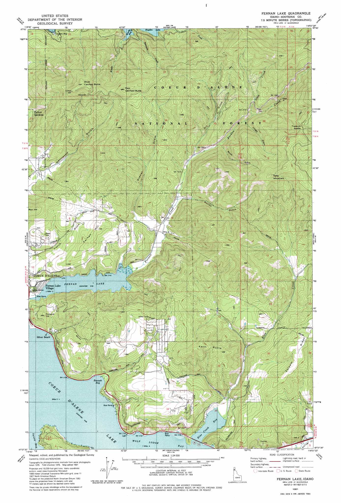
USGS Topo Quad 47116f6 - 1:24,000 scale
| Topo Map Name: | Fernan Lake |
| USGS Topo Quad ID: | 47116f6 |
| Print Size: | ca. 21 1/4" wide x 27" high |
| Southeast Coordinates: | 47.625° N latitude / 116.625° W longitude |
| Map Center Coordinates: | 47.6875° N latitude / 116.6875° W longitude |
| U.S. State: | ID |
| Filename: | o47116f6.jpg |
| Download Map JPG Image: | Fernan Lake topo map 1:24,000 scale |
| Map Type: | Topographic |
| Topo Series: | 7.5´ |
| Map Scale: | 1:24,000 |
| Source of Map Images: | United States Geological Survey (USGS) |
| Alternate Map Versions: |
Lane NW ID 1975, updated 1978 Download PDF Buy paper map Fernan Lake ID 1981, updated 1981 Download PDF Buy paper map Fernan Lake ID 1981, updated 1981 Download PDF Buy paper map Fernan Lake ID 1996, updated 1999 Download PDF Buy paper map Fernan Lake ID 2011 Download PDF Buy paper map Fernan Lake ID 2013 Download PDF Buy paper map |
| FStopo: | US Forest Service topo Fernan Lake is available: Download FStopo PDF Download FStopo TIF |
1:24,000 Topo Quads surrounding Fernan Lake
Spirit Lake West |
Spirit Lake East |
Athol |
Bayview |
Lakeview |
Rathdrum |
Hayden |
Hayden Lake |
Spades Mountain |
Cataract Peak |
Post Falls |
Coeur D'Alene |
Fernan Lake |
Wolf Lodge |
Skitwish Peak |
Rockford Bay |
Mica Bay |
Mount Coeur D'Alene |
Lane |
Rose Lake |
Worley |
Harrison |
Black Lake |
Medimont |
Rochat Peak |
> Back to 47116e1 at 1:100,000 scale
> Back to 47116a1 at 1:250,000 scale
> Back to U.S. Topo Maps home
Fernan Lake topo map: Gazetteer
Fernan Lake: Bays
Bennett Bay elevation 649m 2129′Blue Creek Bay elevation 649m 2129′
Windy Bay elevation 684m 2244′
Fernan Lake: Beaches
Silver Beach elevation 654m 2145′Fernan Lake: Gaps
Treasure Saddle elevation 1138m 3733′Fernan Lake: Lakes
Fernan Lake elevation 649m 2129′Fernan Lake: Populated Places
Fernan Lake Village elevation 652m 2139′Fernan Lake: Ridges
Folsom Ridge elevation 873m 2864′Fernan Lake: Streams
Blue Creek elevation 653m 2142′Colburn Creek elevation 686m 2250′
Harrison Creek elevation 729m 2391′
State Creek elevation 773m 2536′
Windy Creek elevation 683m 2240′
Fernan Lake: Summits
Canfield Buttes elevation 1057m 3467′East Canfield Butte elevation 1147m 3763′
Fernan Hill elevation 821m 2693′
Kelly Mountain elevation 1231m 4038′
Kern Butte elevation 977m 3205′
Potlatch Hill elevation 797m 2614′
West Canfield Butte elevation 1258m 4127′
Fernan Lake: Valleys
Dry Gulch elevation 702m 2303′Jungle Gulch elevation 756m 2480′
Rondo Gulch elevation 667m 2188′
Smith Gulch elevation 716m 2349′
Stacel Draw elevation 666m 2185′
Fernan Lake digital topo map on disk
Buy this Fernan Lake topo map showing relief, roads, GPS coordinates and other geographical features, as a high-resolution digital map file on DVD: