Rathdrum Topo Map Idaho
To zoom in, hover over the map of Rathdrum
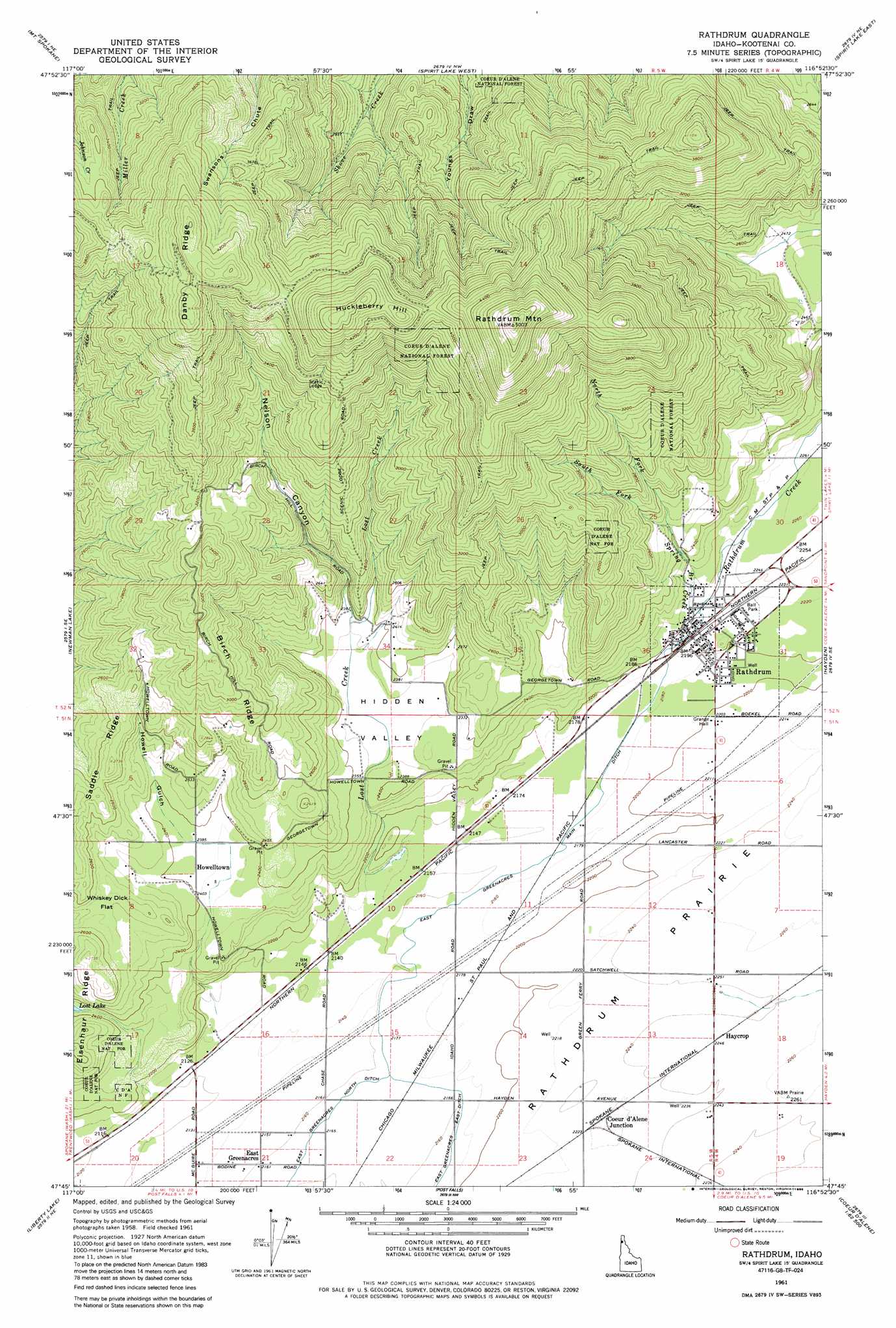
USGS Topo Quad 47116g8 - 1:24,000 scale
| Topo Map Name: | Rathdrum |
| USGS Topo Quad ID: | 47116g8 |
| Print Size: | ca. 21 1/4" wide x 27" high |
| Southeast Coordinates: | 47.75° N latitude / 116.875° W longitude |
| Map Center Coordinates: | 47.8125° N latitude / 116.9375° W longitude |
| U.S. State: | ID |
| Filename: | o47116g8.jpg |
| Download Map JPG Image: | Rathdrum topo map 1:24,000 scale |
| Map Type: | Topographic |
| Topo Series: | 7.5´ |
| Map Scale: | 1:24,000 |
| Source of Map Images: | United States Geological Survey (USGS) |
| Alternate Map Versions: |
Rathdrum ID 1961, updated 1962 Download PDF Buy paper map Rathdrum ID 1961, updated 1977 Download PDF Buy paper map Rathdrum ID 1961, updated 1986 Download PDF Buy paper map Rathdrum ID 1996, updated 1999 Download PDF Buy paper map Rathdrum ID 2011 Download PDF Buy paper map Rathdrum ID 2013 Download PDF Buy paper map |
| FStopo: | US Forest Service topo Rathdrum is available: Download FStopo PDF Download FStopo TIF |
1:24,000 Topo Quads surrounding Rathdrum
Camden |
Tweedie |
Blanchard |
Edgemere |
Careywood |
Mount Kit Carson |
Mount Spokane |
Spirit Lake West |
Spirit Lake East |
Athol |
Foothills |
Newman Lake |
Rathdrum |
Hayden |
Hayden Lake |
Greenacres |
Liberty Lake |
Post Falls |
Coeur D'Alene |
Fernan Lake |
Freeman |
Mica Peak |
Rockford Bay |
Mica Bay |
Mount Coeur D'Alene |
> Back to 47116e1 at 1:100,000 scale
> Back to 47116a1 at 1:250,000 scale
> Back to U.S. Topo Maps home
Rathdrum topo map: Gazetteer
Rathdrum: Basins
Hidden Valley elevation 716m 2349′Rathdrum: Canals
East Greenacres Main Ditch elevation 664m 2178′East Greenacres North Ditch elevation 659m 2162′
Rathdrum: Flats
Whiskey Dick Flat elevation 774m 2539′Rathdrum: Populated Places
Coeur d'Alene Junction elevation 678m 2224′East Greenacres elevation 659m 2162′
Haycrop elevation 687m 2253′
Howelltown elevation 729m 2391′
Rathdrum elevation 674m 2211′
Rathdrum: Ridges
Birch Ridge elevation 965m 3166′Danby Ridge elevation 1312m 4304′
Eisenhour Ridge elevation 833m 2732′
Rathdrum: Streams
Lost Creek elevation 653m 2142′North Fork Spring Branch Creek elevation 733m 2404′
Rathdrum Creek elevation 676m 2217′
South Fork Spring Branch Creek elevation 736m 2414′
Spring Branch Creek elevation 677m 2221′
Rathdrum: Summits
Huckleberry Hill elevation 1369m 4491′Rathdrum Mountain elevation 1522m 4993′
Rathdrum: Valleys
Howell Gulch elevation 730m 2395′Nelson Canyon elevation 747m 2450′
Rathdrum digital topo map on disk
Buy this Rathdrum topo map showing relief, roads, GPS coordinates and other geographical features, as a high-resolution digital map file on DVD: