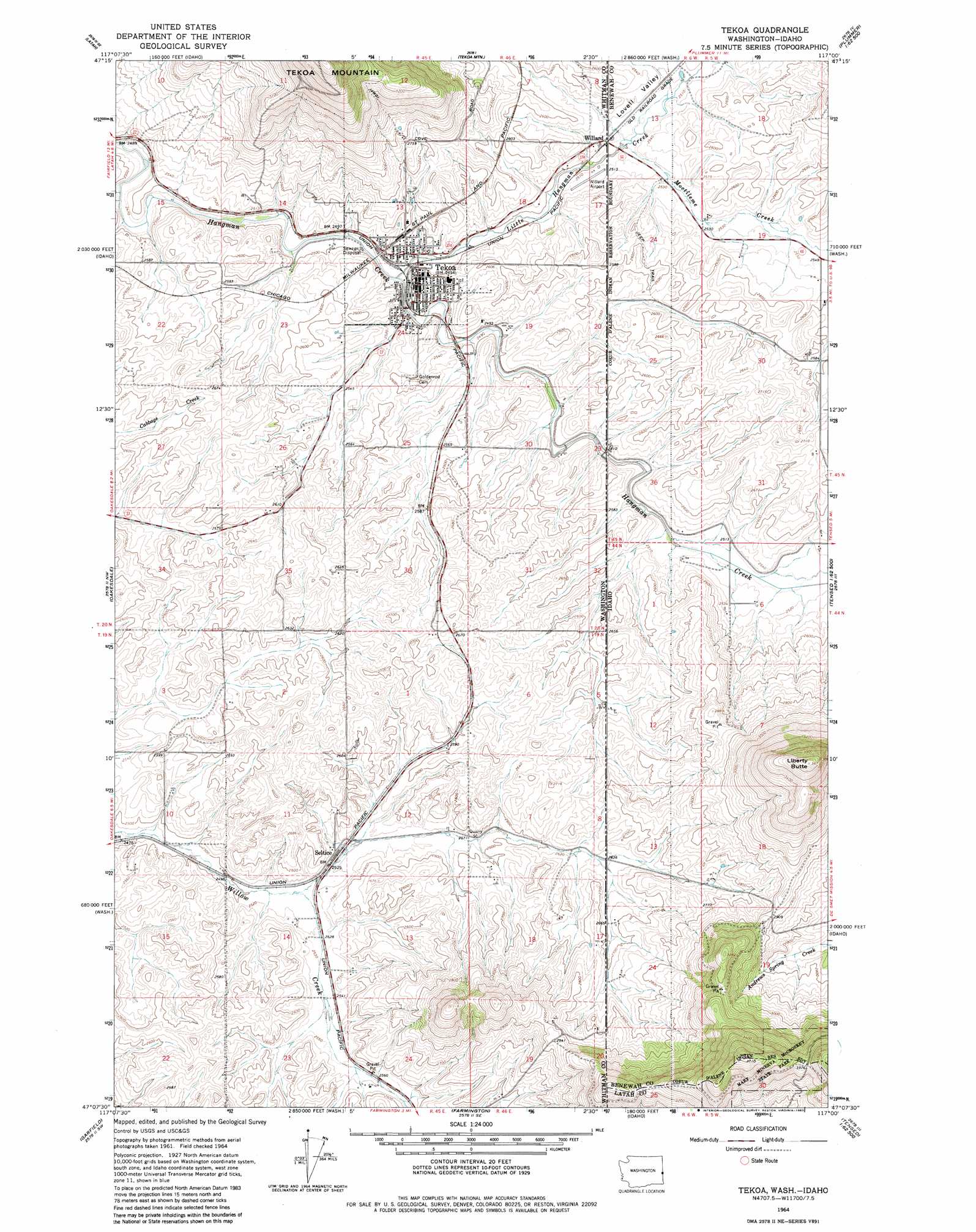
Tekoa Topo Map Washington
To zoom in, hover over the map of Tekoa
USGS Topo Quad 47117b1 - 1:24,000 scale
| Topo Map Name: | Tekoa |
| USGS Topo Quad ID: | 47117b1 |
| Print Size: | ca. 21 1/4" wide x 27" high |
| Southeast Coordinates: | 47.125° N latitude / 117° W longitude |
| Map Center Coordinates: | 47.1875° N latitude / 117.0625° W longitude |
| U.S. States: | WA, ID |
| Filename: | o47117b1.jpg |
| Download Map JPG Image: | Tekoa topo map 1:24,000 scale |
| Map Type: | Topographic |
| Topo Series: | 7.5´ |
| Map Scale: | 1:24,000 |
| Source of Map Images: | United States Geological Survey (USGS) |
| Alternate Map Versions: |
Tekoa WA 1964, updated 1965 Download PDF Buy paper map Tekoa WA 1964, updated 1965 Download PDF Buy paper map Tekoa WA 1964, updated 1983 Download PDF Buy paper map Tekoa WA 2011 Download PDF Buy paper map Tekoa WA 2014 Download PDF Buy paper map |
1:24,000 Topo Quads surrounding Tekoa
Spangle East |
Fairfield |
Setters |
Worley |
Harrison |
Spring Valley |
Latah |
Tekoa Mountain |
Plummer |
Chatcolet |
Rosalia |
Oakesdale |
Tekoa |
Tensed |
Benewah |
Steptoe |
Garfield |
Farmington |
Mission Mountain |
Sanders |
Colfax North |
Elberton |
Palouse |
Potlatch |
Princeton |
> Back to 47117a1 at 1:100,000 scale
> Back to 47116a1 at 1:250,000 scale
> Back to U.S. Topo Maps home
Tekoa topo map: Gazetteer
Tekoa: Airports
Willard Field elevation 768m 2519′Tekoa: Populated Places
Seltice elevation 776m 2545′Tekoa elevation 772m 2532′
Willard elevation 766m 2513′
Willard elevation 766m 2513′
Tekoa: Springs
Hn(os(oskwe' Spring elevation 939m 3080′Tekoa: Streams
Little Hangman Creek elevation 758m 2486′Moctileme Creek elevation 763m 2503′
Tekoa: Summits
Liberty Butte elevation 1118m 3667′St'umt'umm Mountain elevation 969m 3179′
Tekoa: Valleys
Lovell Valley elevation 768m 2519′Tekoa digital topo map on disk
Buy this Tekoa topo map showing relief, roads, GPS coordinates and other geographical features, as a high-resolution digital map file on DVD: