Cheney Topo Map Washington
To zoom in, hover over the map of Cheney
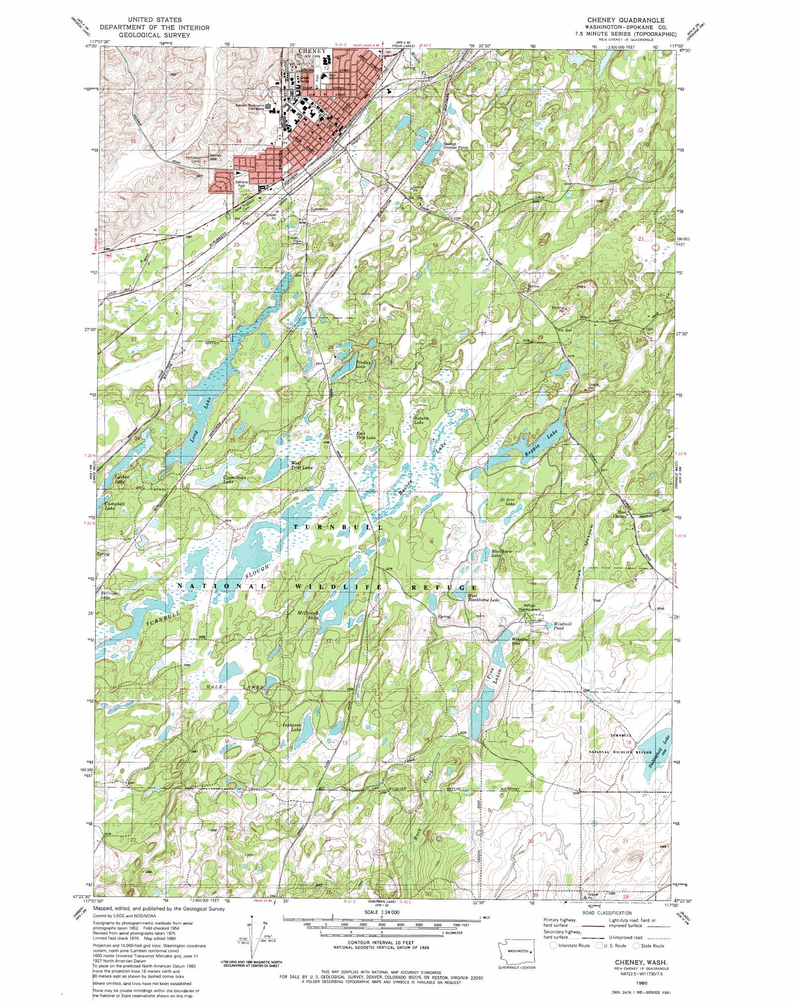
USGS Topo Quad 47117d5 - 1:24,000 scale
| Topo Map Name: | Cheney |
| USGS Topo Quad ID: | 47117d5 |
| Print Size: | ca. 21 1/4" wide x 27" high |
| Southeast Coordinates: | 47.375° N latitude / 117.5° W longitude |
| Map Center Coordinates: | 47.4375° N latitude / 117.5625° W longitude |
| U.S. State: | WA |
| Filename: | o47117d5.jpg |
| Download Map JPG Image: | Cheney topo map 1:24,000 scale |
| Map Type: | Topographic |
| Topo Series: | 7.5´ |
| Map Scale: | 1:24,000 |
| Source of Map Images: | United States Geological Survey (USGS) |
| Alternate Map Versions: |
Cheney WA 1980, updated 1981 Download PDF Buy paper map Cheney WA 1980, updated 1981 Download PDF Buy paper map Cheney WA 2011 Download PDF Buy paper map Cheney WA 2014 Download PDF Buy paper map |
1:24,000 Topo Quads surrounding Cheney
Reardan East |
Deep Creek |
Airway Heights |
Spokane Nw |
Spokane Ne |
Waukon |
Medical Lake |
Four Lakes |
Spokane Sw |
Spokane Se |
Tyler |
Lance Hills |
Cheney |
Spangle West |
Spangle East |
Fishtrap Lake |
Amber |
Chapman Lake |
Plaza |
Spring Valley |
Lamont Ne |
Rock Lake |
Pine City |
Malden |
Rosalia |
> Back to 47117a1 at 1:100,000 scale
> Back to 47116a1 at 1:250,000 scale
> Back to U.S. Topo Maps home
Cheney topo map: Gazetteer
Cheney: Dams
Emtman Dam Number One elevation 705m 2312′Emtman Dam Number Two elevation 702m 2303′
Lower Pine Lake Dam elevation 678m 2224′
Middle Pine Dike Dam elevation 682m 2237′
Winslow Dike Dam elevation 682m 2237′
Cheney: Flats
Phillips Meadow elevation 690m 2263′Cheney: Guts
Turnbull Slough elevation 698m 2290′Cheney: Lakes
Blackhorse Lake elevation 693m 2273′Cossalman Lake elevation 702m 2303′
East Tritt Lake elevation 699m 2293′
Findley Lake elevation 701m 2299′
Hole Lakes elevation 699m 2293′
Isaacson Lake elevation 695m 2280′
Kepple Lake elevation 695m 2280′
Lasher Lake elevation 701m 2299′
Long Lake elevation 701m 2299′
McDowell Lake elevation 698m 2290′
Pine Lakes elevation 678m 2224′
Reeves Lake elevation 699m 2293′
Roberts Lake elevation 699m 2293′
Stubblefield Lake elevation 714m 2342′
Thirty Acre Lake elevation 699m 2293′
West Blackhorse Lake elevation 693m 2273′
West Tritt Lake elevation 699m 2293′
Windmill Pond elevation 688m 2257′
Cheney: Parks
Salnave Park elevation 728m 2388′Sutton Park elevation 738m 2421′
Turnbull National Wildlife Refuge elevation 699m 2293′
Cheney: Populated Places
Cheney elevation 717m 2352′East Cheney elevation 704m 2309′
South Cheney elevation 699m 2293′
Cheney: Reservoirs
Lower Pine Lake elevation 678m 2224′Middle Pine Lake elevation 682m 2237′
Winslow Pool elevation 682m 2237′
Cheney: Streams
Pine Creek Drain elevation 677m 2221′Cheney digital topo map on disk
Buy this Cheney topo map showing relief, roads, GPS coordinates and other geographical features, as a high-resolution digital map file on DVD: