Chattaroy Topo Map Washington
To zoom in, hover over the map of Chattaroy
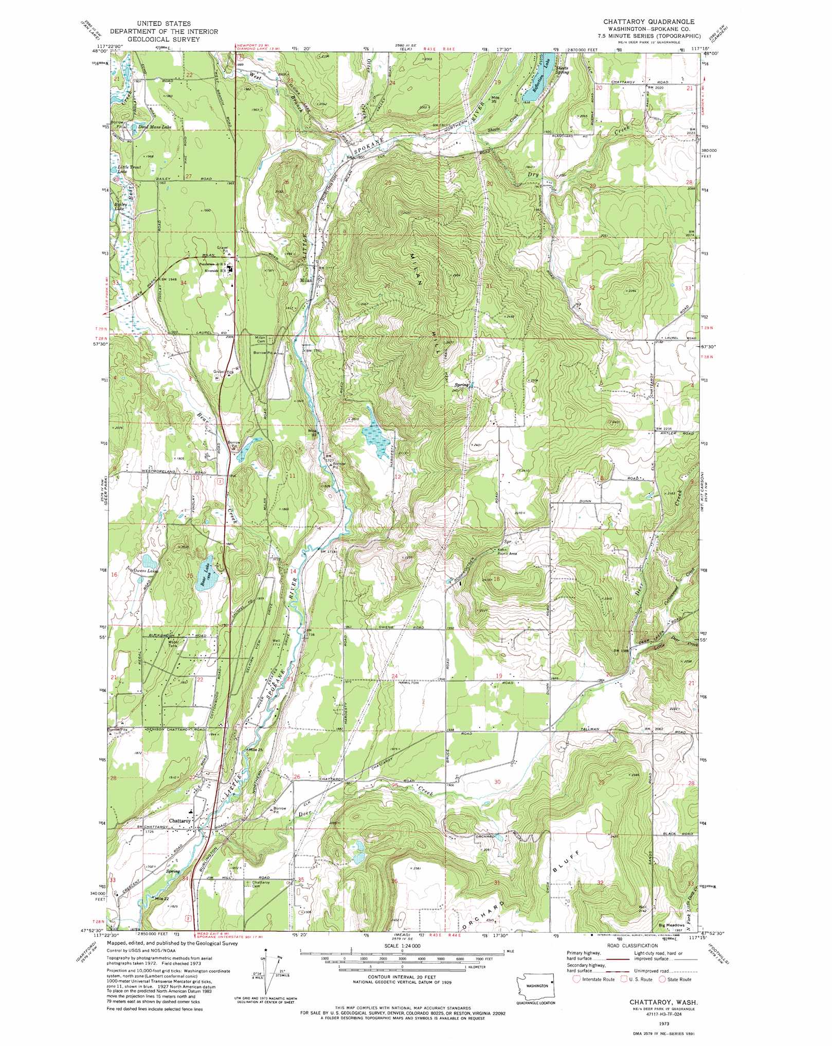
USGS Topo Quad 47117h3 - 1:24,000 scale
| Topo Map Name: | Chattaroy |
| USGS Topo Quad ID: | 47117h3 |
| Print Size: | ca. 21 1/4" wide x 27" high |
| Southeast Coordinates: | 47.875° N latitude / 117.25° W longitude |
| Map Center Coordinates: | 47.9375° N latitude / 117.3125° W longitude |
| U.S. State: | WA |
| Filename: | o47117h3.jpg |
| Download Map JPG Image: | Chattaroy topo map 1:24,000 scale |
| Map Type: | Topographic |
| Topo Series: | 7.5´ |
| Map Scale: | 1:24,000 |
| Source of Map Images: | United States Geological Survey (USGS) |
| Alternate Map Versions: |
Chattaroy WA 1973, updated 1977 Download PDF Buy paper map Chattaroy WA 1973, updated 1986 Download PDF Buy paper map Chattaroy WA 2011 Download PDF Buy paper map Chattaroy WA 2014 Download PDF Buy paper map |
1:24,000 Topo Quads surrounding Chattaroy
Nelson Peak |
Boyer Mountain |
Sacheen Lake |
Diamond Lake |
Newport |
Deer Lake |
Fan Lake |
Elk |
Camden |
Tweedie |
Clayton |
Deer Park |
Chattaroy |
Mount Kit Carson |
Mount Spokane |
Nine Mile Falls |
Dartford |
Mead |
Foothills |
Newman Lake |
Airway Heights |
Spokane Nw |
Spokane Ne |
Greenacres |
Liberty Lake |
> Back to 47117e1 at 1:100,000 scale
> Back to 47116a1 at 1:250,000 scale
> Back to U.S. Topo Maps home
Chattaroy topo map: Gazetteer
Chattaroy: Airports
Lees Airport elevation 575m 1886′Chattaroy: Cliffs
Orchard Bluff elevation 739m 2424′Chattaroy: Dams
Reflection Lake South Dam elevation 556m 1824′Chattaroy: Lakes
Bear Lake elevation 567m 1860′Dead Mans Lake elevation 597m 1958′
Owens Lake elevation 580m 1902′
Chattaroy: Populated Places
Chattaroy elevation 521m 1709′Milan elevation 541m 1774′
Chattaroy: Reservoirs
Reflection Lake elevation 556m 1824′Chattaroy: Springs
Sheets Spring elevation 573m 1879′Chattaroy: Streams
Bear Creek elevation 525m 1722′Cottonwood Creek elevation 616m 2020′
Deer Creek elevation 519m 1702′
Dragoon Creek elevation 513m 1683′
Dry Creek elevation 555m 1820′
Little Deer Creek elevation 605m 1984′
Otter Creek elevation 549m 1801′
Sheets Creek elevation 556m 1824′
West Branch Little Spokane River elevation 551m 1807′
Chattaroy: Summits
Milan Hill elevation 804m 2637′Chattaroy digital topo map on disk
Buy this Chattaroy topo map showing relief, roads, GPS coordinates and other geographical features, as a high-resolution digital map file on DVD: