Soap Lake Topo Map Washington
To zoom in, hover over the map of Soap Lake
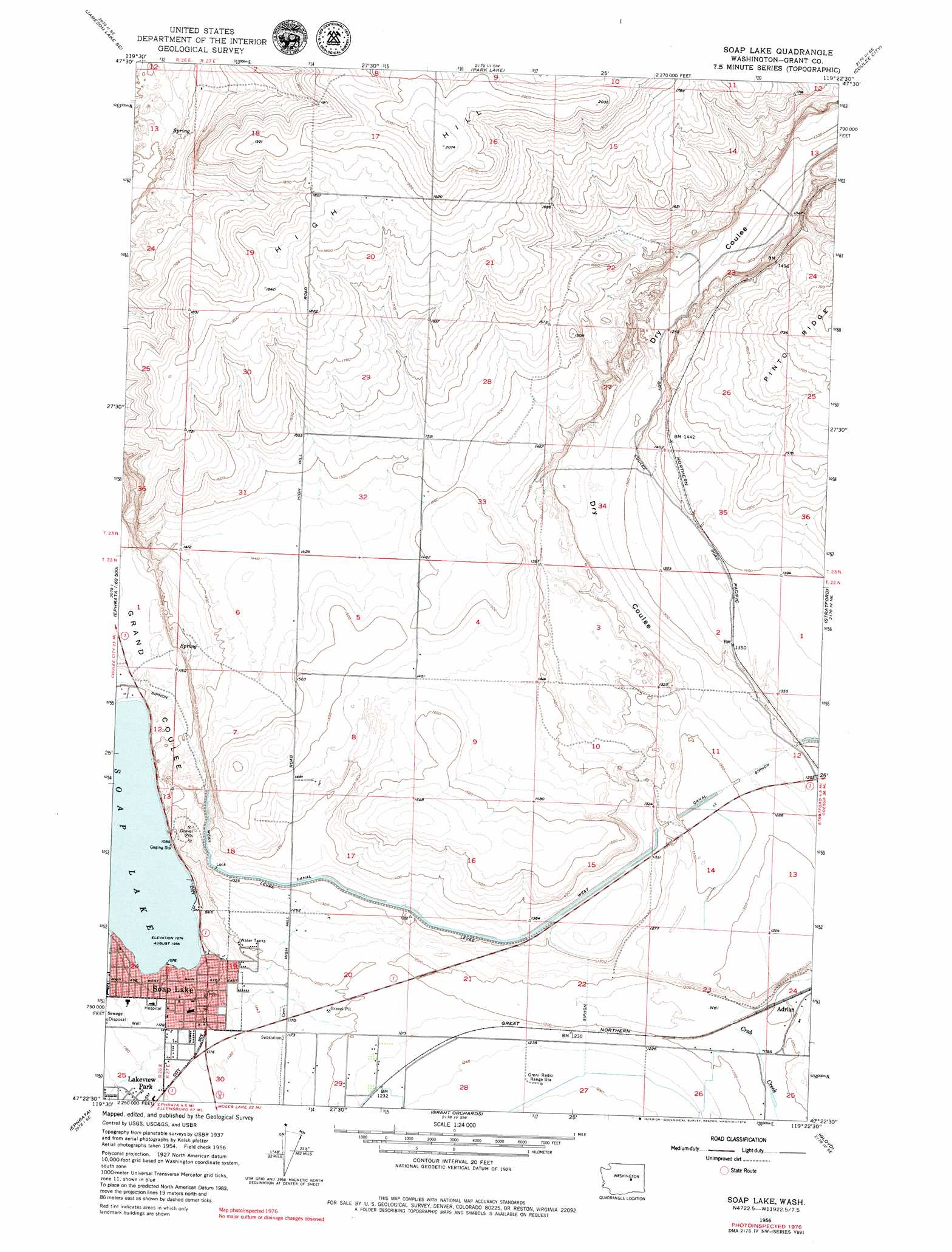
USGS Topo Quad 47119d4 - 1:24,000 scale
| Topo Map Name: | Soap Lake |
| USGS Topo Quad ID: | 47119d4 |
| Print Size: | ca. 21 1/4" wide x 27" high |
| Southeast Coordinates: | 47.375° N latitude / 119.375° W longitude |
| Map Center Coordinates: | 47.4375° N latitude / 119.4375° W longitude |
| U.S. State: | WA |
| Filename: | o47119d4.jpg |
| Download Map JPG Image: | Soap Lake topo map 1:24,000 scale |
| Map Type: | Topographic |
| Topo Series: | 7.5´ |
| Map Scale: | 1:24,000 |
| Source of Map Images: | United States Geological Survey (USGS) |
| Alternate Map Versions: |
Soap Lake WA 1956, updated 1958 Download PDF Buy paper map Soap Lake WA 1956, updated 1971 Download PDF Buy paper map Soap Lake WA 1956, updated 1979 Download PDF Buy paper map Soap Lake WA 2011 Download PDF Buy paper map Soap Lake WA 2014 Download PDF Buy paper map |
1:24,000 Topo Quads surrounding Soap Lake
Jameson Lake West |
Jameson Lake East |
Saint Andrews |
Mold |
Hartline Nw |
Jameson Lake Sw |
Jameson Lake Se |
Park Lake |
Coulee City |
Hartline Sw |
Sagebrush Flat |
Little Soap Lake |
Soap Lake |
Stratford |
Wilson Creek Nw |
Ephrata Sw |
Ephrata |
Grant Orchards |
Gloyd |
Wilson Creek Sw |
Winchester |
Winchester Ne |
Moses Lake Nw |
Moses Lake North |
Wheeler |
> Back to 47119a1 at 1:100,000 scale
> Back to 47118a1 at 1:250,000 scale
> Back to U.S. Topo Maps home
Soap Lake topo map: Gazetteer
Soap Lake: Lakes
Soap Lake elevation 329m 1079′Soap Lake: Populated Places
Soap Lake elevation 337m 1105′Stratford elevation 409m 1341′
Soap Lake: Summits
High Hill elevation 632m 2073′Soap Lake: Valleys
Grand Coulee elevation 329m 1079′Lower Grand Coulee elevation 329m 1079′
Soap Lake digital topo map on disk
Buy this Soap Lake topo map showing relief, roads, GPS coordinates and other geographical features, as a high-resolution digital map file on DVD: