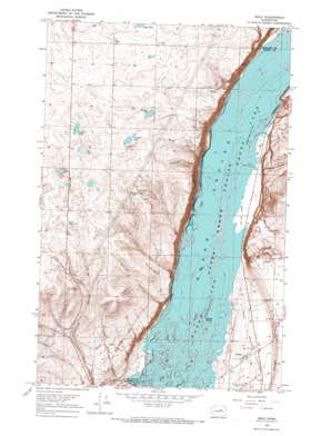
Mold Topo Map Washington
To zoom in, hover over the map of Mold
USGS Topo Quad 47119f3 - 1:24,000 scale
| Topo Map Name: | Mold |
| USGS Topo Quad ID: | 47119f3 |
| Print Size: | ca. 21 1/4" wide x 27" high |
| Southeast Coordinates: | 47.625° N latitude / 119.25° W longitude |
| Map Center Coordinates: | 47.6875° N latitude / 119.3125° W longitude |
| U.S. State: | WA |
| Filename: | o47119f3.jpg |
| Download Map JPG Image: | Mold topo map 1:24,000 scale |
| Map Type: | Topographic |
| Topo Series: | 7.5´ |
| Map Scale: | 1:24,000 |
| Source of Map Images: | United States Geological Survey (USGS) |
| Alternate Map Versions: |
Mold WA 1965, updated 1967 Download PDF Buy paper map Mold WA 2011 Download PDF Buy paper map Mold WA 2014 Download PDF Buy paper map |
1:24,000 Topo Quads surrounding Mold
> Back to 47119e1 at 1:100,000 scale
> Back to 47118a1 at 1:250,000 scale
> Back to U.S. Topo Maps home
Mold topo map: Gazetteer
Mold: Islands
Goose Island elevation 480m 1574′Mold: Lakes
Durk Lake elevation 748m 2454′Heinlen Lake elevation 728m 2388′
Jollys Lake elevation 709m 2326′
Jollys Pond elevation 725m 2378′
Ludtke Lake elevation 709m 2326′
Sullivan Lake elevation 737m 2417′
Tule Lake elevation 721m 2365′
Mold: Pillars
Pilot Rock elevation 791m 2595′Mold: Populated Places
Dry Falls Junction elevation 485m 1591′Fordair elevation 506m 1660′
Mold elevation 704m 2309′
Mold: Valleys
Chase Draw elevation 480m 1574′McDonald Draw elevation 494m 1620′
Purdue Draw elevation 482m 1581′
Shrock Draw elevation 481m 1578′
Mold digital topo map on disk
Buy this Mold topo map showing relief, roads, GPS coordinates and other geographical features, as a high-resolution digital map file on DVD:


