Whiskey Dick Mountain Topo Map Washington
To zoom in, hover over the map of Whiskey Dick Mountain
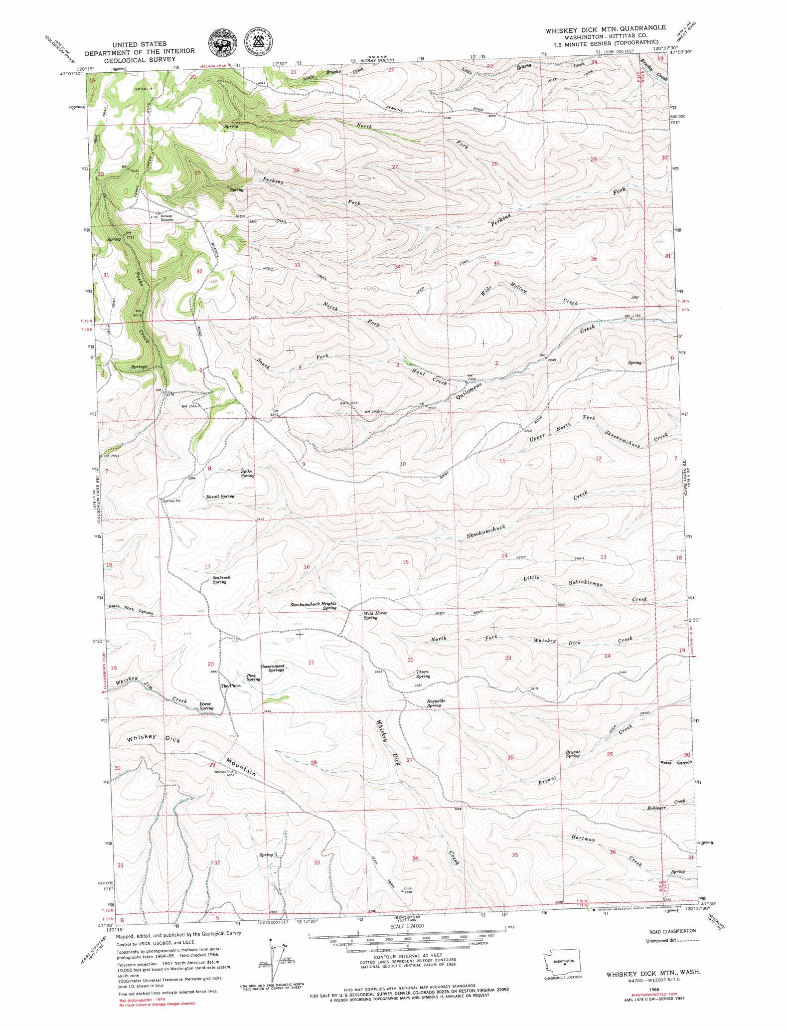
USGS Topo Quad 47120a2 - 1:24,000 scale
| Topo Map Name: | Whiskey Dick Mountain |
| USGS Topo Quad ID: | 47120a2 |
| Print Size: | ca. 21 1/4" wide x 27" high |
| Southeast Coordinates: | 47° N latitude / 120.125° W longitude |
| Map Center Coordinates: | 47.0625° N latitude / 120.1875° W longitude |
| U.S. State: | WA |
| Filename: | o47120a2.jpg |
| Download Map JPG Image: | Whiskey Dick Mountain topo map 1:24,000 scale |
| Map Type: | Topographic |
| Topo Series: | 7.5´ |
| Map Scale: | 1:24,000 |
| Source of Map Images: | United States Geological Survey (USGS) |
| Alternate Map Versions: |
Whiskey Dick Mtn. WA 1966, updated 1968 Download PDF Buy paper map Whiskey Dick Mtn. WA 1966, updated 1979 Download PDF Buy paper map Whiskey Dick Mountain WA 2011 Download PDF Buy paper map Whiskey Dick Mountain WA 2014 Download PDF Buy paper map |
1:24,000 Topo Quads surrounding Whiskey Dick Mountain
Mission Peak |
Wenatchee Heights |
Malaga |
Rock Island Dam |
Appledale |
Naneum Canyon |
Colockum Pass |
Stray Gulch |
West Bar |
Babcock Ridge |
Colockum Pass Sw |
Colockum Pass Se |
Whiskey Dick Mountain |
Cape Horn Se |
Evergreen Ridge |
Kittitas |
East Kittitas |
Boylston |
Ginkgo |
Vantage |
Wymer |
Badger Gap |
Mcdonald Spring |
Doris |
Beverly |
> Back to 47120a1 at 1:100,000 scale
> Back to 47120a1 at 1:250,000 scale
> Back to U.S. Topo Maps home
Whiskey Dick Mountain topo map: Gazetteer
Whiskey Dick Mountain: Parks
Quilomene Wildlife Recreation Area elevation 841m 2759′Whiskey Dick Mountain: Springs
Basalt Spring elevation 1056m 3464′Bryant Spring elevation 655m 2148′
Dorse Spring elevation 1014m 3326′
Government Springs elevation 1023m 3356′
Pine Spring elevation 1033m 3389′
Reynolds Spring elevation 983m 3225′
Seabrock Spring elevation 1057m 3467′
Skookumchuck Heights Spring elevation 1013m 3323′
Spike Spring elevation 1015m 3330′
Thorn Spring elevation 986m 3234′
Wild Horse Spring elevation 1004m 3293′
Whiskey Dick Mountain: Streams
Hunt Creek elevation 701m 2299′North Fork Hunt Creek elevation 763m 2503′
North Fork Perkins Fork elevation 623m 2043′
South Fork Hunt Creek elevation 763m 2503′
Wide Hollow Creek elevation 570m 1870′
Whiskey Dick Mountain: Summits
Whiskey Dick Mountain elevation 1182m 3877′Whiskey Dick Mountain digital topo map on disk
Buy this Whiskey Dick Mountain topo map showing relief, roads, GPS coordinates and other geographical features, as a high-resolution digital map file on DVD: