Cashmere Topo Map Washington
To zoom in, hover over the map of Cashmere
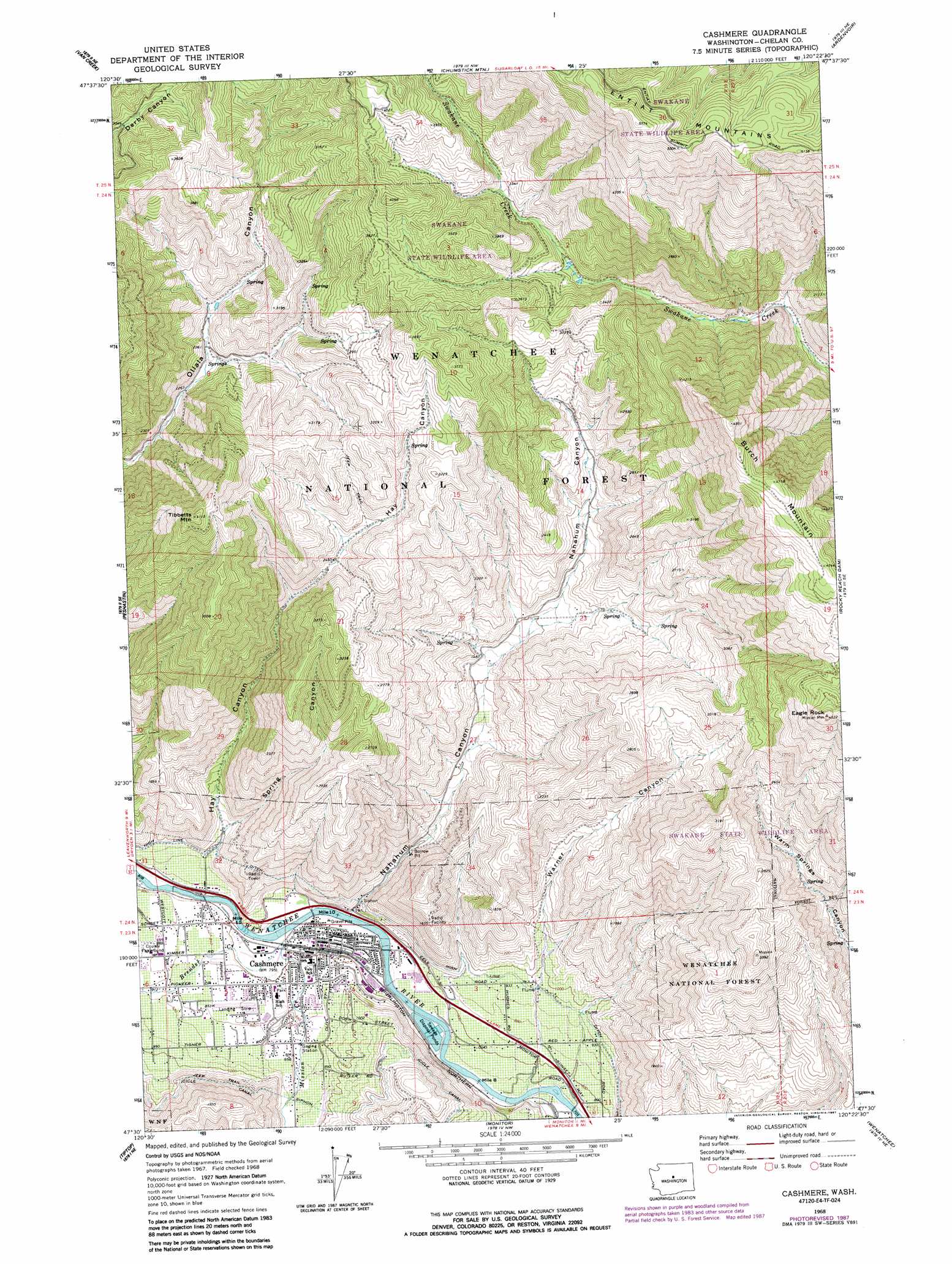
USGS Topo Quad 47120e4 - 1:24,000 scale
| Topo Map Name: | Cashmere |
| USGS Topo Quad ID: | 47120e4 |
| Print Size: | ca. 21 1/4" wide x 27" high |
| Southeast Coordinates: | 47.5° N latitude / 120.375° W longitude |
| Map Center Coordinates: | 47.5625° N latitude / 120.4375° W longitude |
| U.S. State: | WA |
| Filename: | o47120e4.jpg |
| Download Map JPG Image: | Cashmere topo map 1:24,000 scale |
| Map Type: | Topographic |
| Topo Series: | 7.5´ |
| Map Scale: | 1:24,000 |
| Source of Map Images: | United States Geological Survey (USGS) |
| Alternate Map Versions: |
Cashmere WA 1968, updated 1972 Download PDF Buy paper map Cashmere WA 1968, updated 1987 Download PDF Buy paper map Cashmere WA 2003, updated 2006 Download PDF Buy paper map Cashmere WA 2011 Download PDF Buy paper map Cashmere WA 2014 Download PDF Buy paper map |
| FStopo: | US Forest Service topo Cashmere is available: Download FStopo PDF Download FStopo TIF |
1:24,000 Topo Quads surrounding Cashmere
Plain |
Sugarloaf Peak |
Tyee Mountain |
Baldy Mountain |
Winesap |
Winton |
Van Creek |
Chumstick Mountain |
Ardenvoir |
Entiat |
Leavenworth |
Peshastin |
Cashmere |
Rocky Reach Dam |
Orondo |
Blewett |
Tiptop |
Monitor |
Wenatchee |
Rock Island |
Liberty |
Swauk Pass |
Mission Peak |
Wenatchee Heights |
Malaga |
> Back to 47120e1 at 1:100,000 scale
> Back to 47120a1 at 1:250,000 scale
> Back to U.S. Topo Maps home
Cashmere topo map: Gazetteer
Cashmere: Airports
Cascade Heliport elevation 239m 784′Cashmere-Dryden Airport elevation 262m 859′
Cashmere: Canals
Icicle Canal elevation 391m 1282′Cashmere: Parks
Ardetta Park elevation 241m 790′Cashmere Avenue Park elevation 236m 774′
John Simpson Memorial Park elevation 247m 810′
Natatoruim Park elevation 244m 800′
Cashmere: Populated Places
Cashmere elevation 241m 790′Cashmere: Streams
Brender Creek elevation 241m 790′Mission Creek elevation 242m 793′
Cashmere: Summits
Burch Mountain elevation 1495m 4904′Eagle Rock elevation 1381m 4530′
Tibbetts Mountain elevation 1248m 4094′
Cashmere: Valleys
Hay Canyon elevation 289m 948′Nahahum Canyon elevation 240m 787′
Spring Canyon elevation 310m 1017′
Warner Canyon elevation 294m 964′
Cashmere digital topo map on disk
Buy this Cashmere topo map showing relief, roads, GPS coordinates and other geographical features, as a high-resolution digital map file on DVD: