Chiwaukum Mountains Topo Map Washington
To zoom in, hover over the map of Chiwaukum Mountains
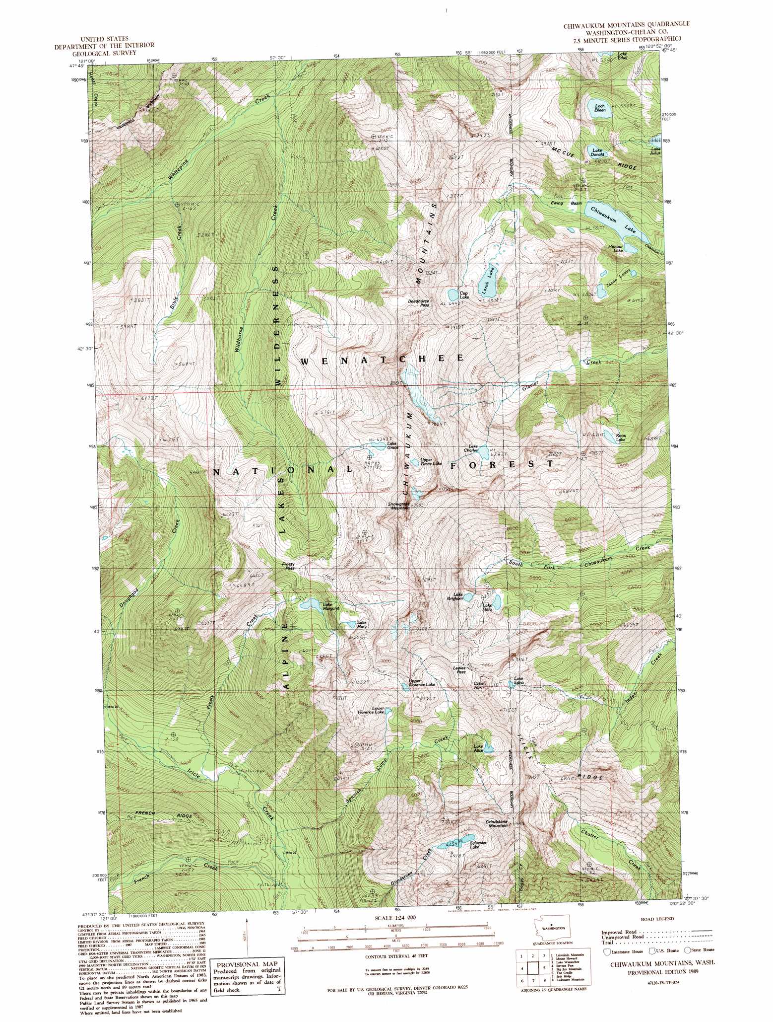
USGS Topo Quad 47120f8 - 1:24,000 scale
| Topo Map Name: | Chiwaukum Mountains |
| USGS Topo Quad ID: | 47120f8 |
| Print Size: | ca. 21 1/4" wide x 27" high |
| Southeast Coordinates: | 47.625° N latitude / 120.875° W longitude |
| Map Center Coordinates: | 47.6875° N latitude / 120.9375° W longitude |
| U.S. State: | WA |
| Filename: | o47120f8.jpg |
| Download Map JPG Image: | Chiwaukum Mountains topo map 1:24,000 scale |
| Map Type: | Topographic |
| Topo Series: | 7.5´ |
| Map Scale: | 1:24,000 |
| Source of Map Images: | United States Geological Survey (USGS) |
| Alternate Map Versions: |
Chiwaukum Mountains WA 1989, updated 1989 Download PDF Buy paper map Chiwaukum Mountains WA 1989, updated 1989 Download PDF Buy paper map Chiwaukum Mountains WA 2004, updated 2008 Download PDF Buy paper map Chiwaukum Mountains WA 2011 Download PDF Buy paper map Chiwaukum Mountains WA 2014 Download PDF Buy paper map |
| FStopo: | US Forest Service topo Chiwaukum Mountains is available: Download FStopo PDF Download FStopo TIF |
1:24,000 Topo Quads surrounding Chiwaukum Mountains
Benchmark Mountain |
Poe Mountain |
Mount David |
Schaefer Lake |
Chikamin Creek |
Captain Point |
Labyrinth Mountain |
Mount Howard |
Lake Wenatchee |
Plain |
Scenic |
Stevens Pass |
Chiwaukum Mountains |
Big Jim Mountain |
Winton |
Mount Daniel |
The Cradle |
Jack Ridge |
Cashmere Mountain |
Leavenworth |
Polallie Ridge |
Davis Peak |
Mount Stuart |
Enchantment Lakes |
Blewett |
> Back to 47120e1 at 1:100,000 scale
> Back to 47120a1 at 1:250,000 scale
> Back to U.S. Topo Maps home
Chiwaukum Mountains topo map: Gazetteer
Chiwaukum Mountains: Basins
Ewing Basin elevation 1592m 5223′Chiwaukum Mountains: Gaps
Deadhorse Pass elevation 2153m 7063′Frosty Pass elevation 1754m 5754′
Ladies Pass elevation 2051m 6729′
Chiwaukum Mountains: Lakes
Chiwaukum Lake elevation 1589m 5213′Cup Lake elevation 1969m 6459′
Honour Lake elevation 1596m 5236′
Jason Lakes elevation 1780m 5839′
Knox Lake elevation 1900m 6233′
Lake Alice elevation 1840m 6036′
Lake Brigham elevation 1778m 5833′
Lake Charles elevation 1922m 6305′
Lake Donald elevation 1791m 5875′
Lake Edna elevation 2058m 6751′
Lake Flore elevation 1742m 5715′
Lake Grace elevation 1912m 6272′
Lake Jason elevation 1753m 5751′
Lake Julius elevation 1583m 5193′
Lake Margaret elevation 1653m 5423′
Lake Mary elevation 1864m 6115′
Lake Sylvester elevation 1908m 6259′
Larch Lake elevation 1854m 6082′
Loch Eileen elevation 1680m 5511′
Lower Florence Lake elevation 1766m 5793′
Upper Florence Lake elevation 1988m 6522′
Upper Grace Lake elevation 2108m 6916′
Chiwaukum Mountains: Ranges
Chiwaukum Mountains elevation 2000m 6561′Chiwaukum Mountains: Streams
Brule Creek elevation 1034m 3392′French Creek elevation 885m 2903′
Frosty Creek elevation 911m 2988′
Spanish Camp Creek elevation 891m 2923′
Wildhorse Creek elevation 992m 3254′
Chiwaukum Mountains: Summits
Cape Horn elevation 2172m 7125′Grindstone Mountain elevation 2250m 7381′
Snowgrass Mountain elevation 2145m 7037′
Chiwaukum Mountains digital topo map on disk
Buy this Chiwaukum Mountains topo map showing relief, roads, GPS coordinates and other geographical features, as a high-resolution digital map file on DVD: