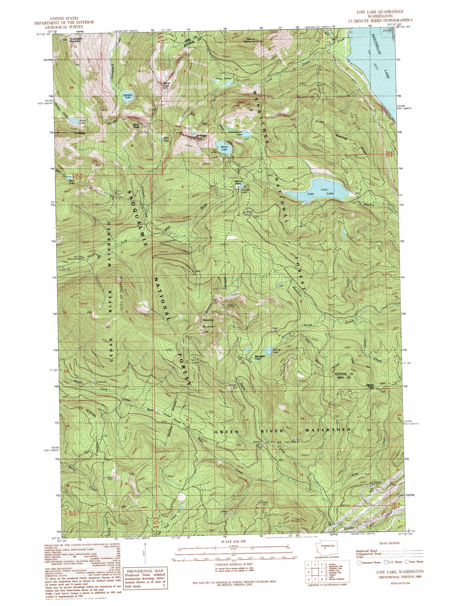
Lost Lake Topo Map Washington
To zoom in, hover over the map of Lost Lake
USGS Topo Quad 47121c4 - 1:24,000 scale
| Topo Map Name: | Lost Lake |
| USGS Topo Quad ID: | 47121c4 |
| Print Size: | ca. 21 1/4" wide x 27" high |
| Southeast Coordinates: | 47.25° N latitude / 121.375° W longitude |
| Map Center Coordinates: | 47.3125° N latitude / 121.4375° W longitude |
| U.S. State: | WA |
| Filename: | o47121c4.jpg |
| Download Map JPG Image: | Lost Lake topo map 1:24,000 scale |
| Map Type: | Topographic |
| Topo Series: | 7.5´ |
| Map Scale: | 1:24,000 |
| Source of Map Images: | United States Geological Survey (USGS) |
| Alternate Map Versions: |
Lost Lake WA 1989, updated 1989 Download PDF Buy paper map Lost Lake WA 1989, updated 1989 Download PDF Buy paper map Lost Lake WA 2011 Download PDF Buy paper map Lost Lake WA 2014 Download PDF Buy paper map |
| FStopo: | US Forest Service topo Lost Lake is available: Download FStopo PDF Download FStopo TIF |
1:24,000 Topo Quads surrounding Lost Lake
Mount Si |
Lake Philippa |
Snoqualmie Lake |
Big Snow Mountain |
Mount Daniel |
Chester Morse Lake |
Bandera |
Snoqualmie Pass |
Chikamin Peak |
Polallie Ridge |
Cougar Mountain |
Findley Lake |
Lost Lake |
Stampede Pass |
Kachess Lake |
Greenwater |
Nagrom |
Lester |
Blowout Mountain |
Easton |
Clear West Peak |
Sun Top |
Noble Knob |
Raven Roost |
Mount Clifty |
> Back to 47121a1 at 1:100,000 scale
> Back to 47120a1 at 1:250,000 scale
> Back to U.S. Topo Maps home
Lost Lake topo map: Gazetteer
Lost Lake: Gaps
Cedar Notch elevation 985m 3231′Dandy Pass elevation 1125m 3690′
Meadow Pass elevation 1104m 3622′
Yakima Pass elevation 1091m 3579′
Lost Lake: Lakes
Abiel Lake elevation 1311m 4301′Annette Lake elevation 1105m 3625′
Bear Lake elevation 1272m 4173′
Cottonwood Lake elevation 1193m 3914′
Lost Lake elevation 943m 3093′
Mirror Lake elevation 1280m 4199′
Scout Lake elevation 1178m 3864′
Stirrup Lake elevation 1082m 3549′
Twilight Lake elevation 1091m 3579′
Twin Lakes elevation 949m 3113′
Lost Lake: Parks
Fort Tilton Historical Marker elevation 748m 2454′Lost Lake: Ridges
Roaring Ridge elevation 1243m 4078′Lost Lake: Streams
Cold Creek elevation 772m 2532′Dandy Creek elevation 899m 2949′
East Creek elevation 607m 1991′
Mill Creek elevation 769m 2522′
Rocky Run elevation 773m 2536′
Snow Creek elevation 599m 1965′
Stirrup Creek elevation 940m 3083′
Tinkham Creek elevation 806m 2644′
West Creek elevation 619m 2030′
Lost Lake: Summits
Abiel Peak elevation 1628m 5341′Humpback Mountain elevation 1558m 5111′
Meadow Mountain elevation 1643m 5390′
Mount Catherine elevation 1512m 4960′
Silver Peak elevation 1675m 5495′
Tinkham Peak elevation 1622m 5321′
Lost Lake: Trails
Annette Lake Trail elevation 1024m 3359′Cascade Crest Trail elevation 1142m 3746′
Lost Lake digital topo map on disk
Buy this Lost Lake topo map showing relief, roads, GPS coordinates and other geographical features, as a high-resolution digital map file on DVD: