Mount Daniel Topo Map Washington
To zoom in, hover over the map of Mount Daniel
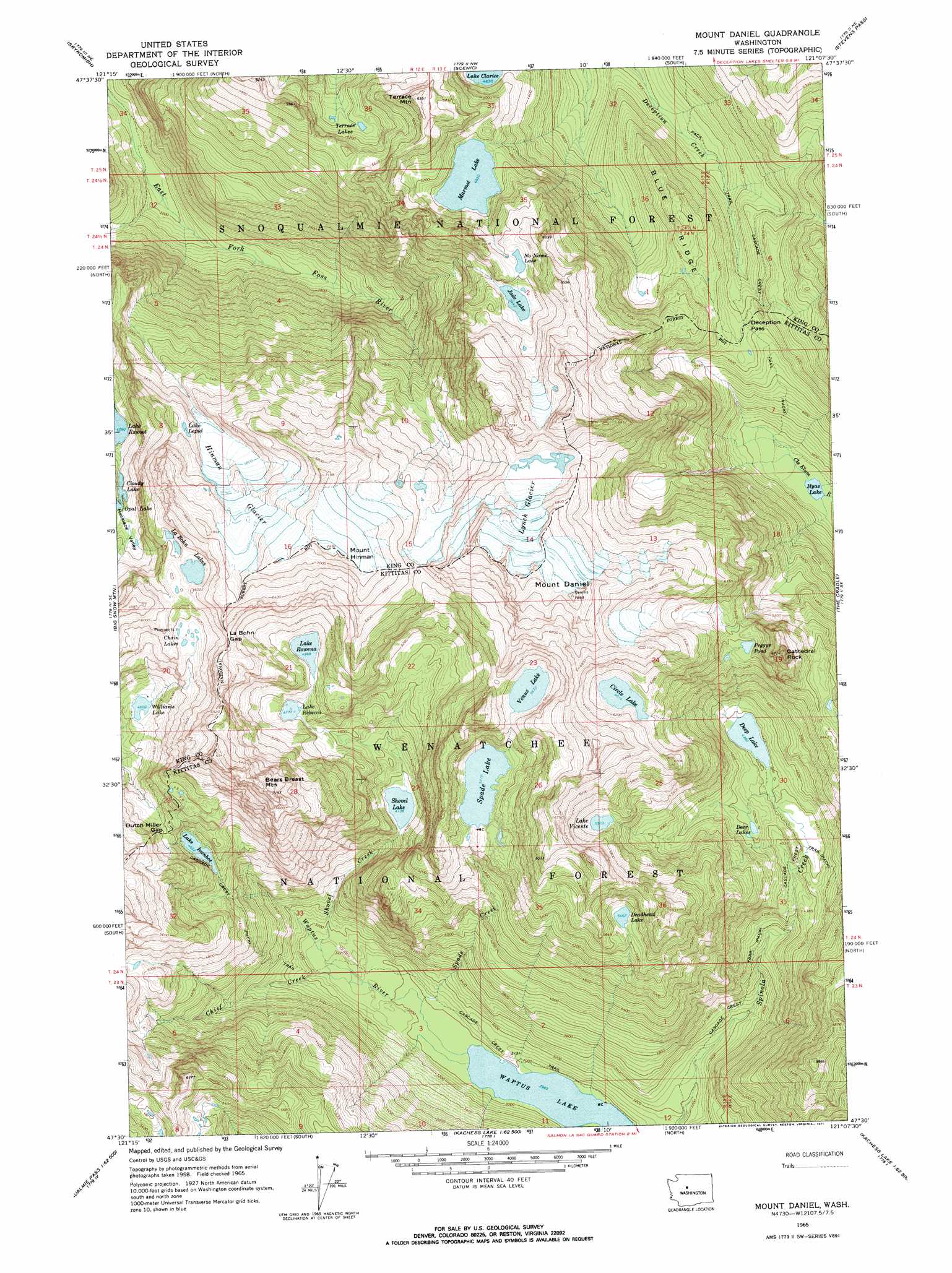
USGS Topo Quad 47121e2 - 1:24,000 scale
| Topo Map Name: | Mount Daniel |
| USGS Topo Quad ID: | 47121e2 |
| Print Size: | ca. 21 1/4" wide x 27" high |
| Southeast Coordinates: | 47.5° N latitude / 121.125° W longitude |
| Map Center Coordinates: | 47.5625° N latitude / 121.1875° W longitude |
| U.S. State: | WA |
| Filename: | o47121e2.jpg |
| Download Map JPG Image: | Mount Daniel topo map 1:24,000 scale |
| Map Type: | Topographic |
| Topo Series: | 7.5´ |
| Map Scale: | 1:24,000 |
| Source of Map Images: | United States Geological Survey (USGS) |
| Alternate Map Versions: |
Mount Daniel WA 1965, updated 1967 Download PDF Buy paper map Mount Daniel WA 1965, updated 1971 Download PDF Buy paper map Mount Daniel WA 1965, updated 1971 Download PDF Buy paper map Mount Daniel WA 2011 Download PDF Buy paper map Mount Daniel WA 2014 Download PDF Buy paper map |
| FStopo: | US Forest Service topo Mount Daniel is available: Download FStopo PDF Download FStopo TIF |
1:24,000 Topo Quads surrounding Mount Daniel
Baring |
Evergreen Mountain |
Captain Point |
Labyrinth Mountain |
Mount Howard |
Grotto |
Skykomish |
Scenic |
Stevens Pass |
Chiwaukum Mountains |
Snoqualmie Lake |
Big Snow Mountain |
Mount Daniel |
The Cradle |
Jack Ridge |
Snoqualmie Pass |
Chikamin Peak |
Polallie Ridge |
Davis Peak |
Mount Stuart |
Lost Lake |
Stampede Pass |
Kachess Lake |
Cle Elum Lake |
Teanaway Butte |
> Back to 47121e1 at 1:100,000 scale
> Back to 47120a1 at 1:250,000 scale
> Back to U.S. Topo Maps home
Mount Daniel topo map: Gazetteer
Mount Daniel: Gaps
Cathedral Pass elevation 1698m 5570′Deception Pass elevation 1365m 4478′
Dutch Miller Gap elevation 1524m 5000′
La Bohn Gap elevation 1786m 5859′
Mount Daniel: Glaciers
Hinman Glacier elevation 1872m 6141′Lynch Glacier elevation 2017m 6617′
Mount Daniel: Lakes
Chain Lakes elevation 1685m 5528′Circle Lake elevation 1834m 6017′
Deadhead Lake elevation 1668m 5472′
Deep Lake elevation 1337m 4386′
Deer Lakes elevation 1396m 4580′
Hyas Lake elevation 1058m 3471′
Jade Lake elevation 1660m 5446′
La Bohn Lakes elevation 1767m 5797′
Lake Ivanhoe elevation 1419m 4655′
Lake Lepul elevation 1801m 5908′
Lake Rebecca elevation 1457m 4780′
Lake Rowena elevation 1516m 4973′
Lake Vicente elevation 1679m 5508′
Marmot Lake elevation 1504m 4934′
No Name Lake elevation 1719m 5639′
Peggys Pond elevation 1704m 5590′
Shovel Lake elevation 1263m 4143′
Spade Lake elevation 1589m 5213′
Terrace Lakes elevation 1520m 4986′
Venus Lake elevation 1730m 5675′
Waptus Lake elevation 904m 2965′
Williams Lake elevation 1403m 4603′
Mount Daniel: Ridges
Blue Ridge elevation 1527m 5009′Escondido Ridge elevation 1863m 6112′
Mount Daniel: Streams
Chief Creek elevation 926m 3038′Shovel Creek elevation 947m 3106′
Spade Creek elevation 915m 3001′
Mount Daniel: Summits
Bears Breast Mountain elevation 2185m 7168′Cathedral Rock elevation 1997m 6551′
Mount Daniel elevation 2402m 7880′
Mount Hinman elevation 2262m 7421′
Terrace Mountain elevation 1905m 6250′
Mount Daniel digital topo map on disk
Buy this Mount Daniel topo map showing relief, roads, GPS coordinates and other geographical features, as a high-resolution digital map file on DVD: