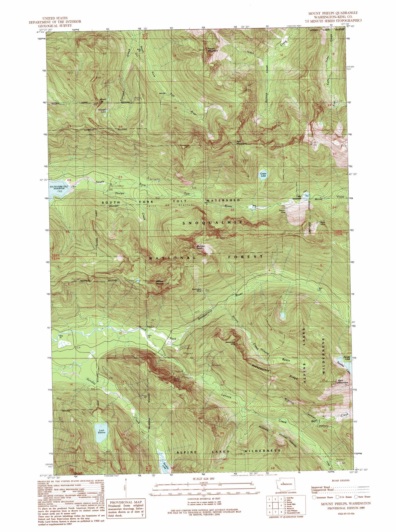
Mount Phelps Topo Map Washington
To zoom in, hover over the map of Mount Phelps
USGS Topo Quad 47121f5 - 1:24,000 scale
| Topo Map Name: | Mount Phelps |
| USGS Topo Quad ID: | 47121f5 |
| Print Size: | ca. 21 1/4" wide x 27" high |
| Southeast Coordinates: | 47.625° N latitude / 121.5° W longitude |
| Map Center Coordinates: | 47.6875° N latitude / 121.5625° W longitude |
| U.S. State: | WA |
| Filename: | o47121f5.jpg |
| Download Map JPG Image: | Mount Phelps topo map 1:24,000 scale |
| Map Type: | Topographic |
| Topo Series: | 7.5´ |
| Map Scale: | 1:24,000 |
| Source of Map Images: | United States Geological Survey (USGS) |
| Alternate Map Versions: |
Mount Phelps WA 1989, updated 1989 Download PDF Buy paper map Mount Phelps WA 1989, updated 1989 Download PDF Buy paper map Mount Phelps WA 2011 Download PDF Buy paper map Mount Phelps WA 2014 Download PDF Buy paper map |
| FStopo: | US Forest Service topo Mount Phelps is available: Download FStopo PDF Download FStopo TIF |
1:24,000 Topo Quads surrounding Mount Phelps
Lake Chaplain |
Wallace Lake |
Mount Stickney |
Monte Cristo |
Blanca Lake |
Sultan |
Gold Bar |
Index |
Baring |
Evergreen Mountain |
Lake Joy |
Tolt Reservoir |
Mount Phelps |
Grotto |
Skykomish |
Snoqualmie |
Mount Si |
Lake Philippa |
Snoqualmie Lake |
Big Snow Mountain |
North Bend |
Chester Morse Lake |
Bandera |
Snoqualmie Pass |
Chikamin Peak |
> Back to 47121e1 at 1:100,000 scale
> Back to 47120a1 at 1:250,000 scale
> Back to U.S. Topo Maps home
Mount Phelps topo map: Gazetteer
Mount Phelps: Areas
South Fork Tolt Watershed elevation 596m 1955′Mount Phelps: Basins
Illinois Basin elevation 1033m 3389′Mount Phelps: Lakes
Bench Lake elevation 1279m 4196′Crater Lake elevation 1068m 3503′
Lake Elizabeth elevation 871m 2857′
Loch Katrine elevation 885m 2903′
Paradise Lakes elevation 1251m 4104′
Sunday Lake elevation 574m 1883′
Titicaed Lake elevation 1094m 3589′
Mount Phelps: Mines
Apex Mine elevation 1122m 3681′Beaverdale Mine elevation 1142m 3746′
Blackhawk Mine elevation 798m 2618′
Damon Mine elevation 993m 3257′
Lennox Mines elevation 762m 2500′
Mount Phelps: Ridges
Prospectors Ridge elevation 1292m 4238′Mount Phelps: Streams
Bear Creek elevation 645m 2116′Cougar Creek elevation 671m 2201′
Illinois Creek elevation 597m 1958′
Lennox Creek elevation 472m 1548′
Phelps Creek elevation 548m 1797′
Salmon Creek elevation 637m 2089′
Titicaed Creek elevation 605m 1984′
Mount Phelps: Summits
Bare Mountain elevation 1588m 5209′Frozen Mountain elevation 1498m 4914′
McClain Peaks elevation 1687m 5534′
Mount Lee elevation 1338m 4389′
Mount Phelps elevation 1669m 5475′
Red Mountain elevation 1646m 5400′
Mount Phelps digital topo map on disk
Buy this Mount Phelps topo map showing relief, roads, GPS coordinates and other geographical features, as a high-resolution digital map file on DVD: