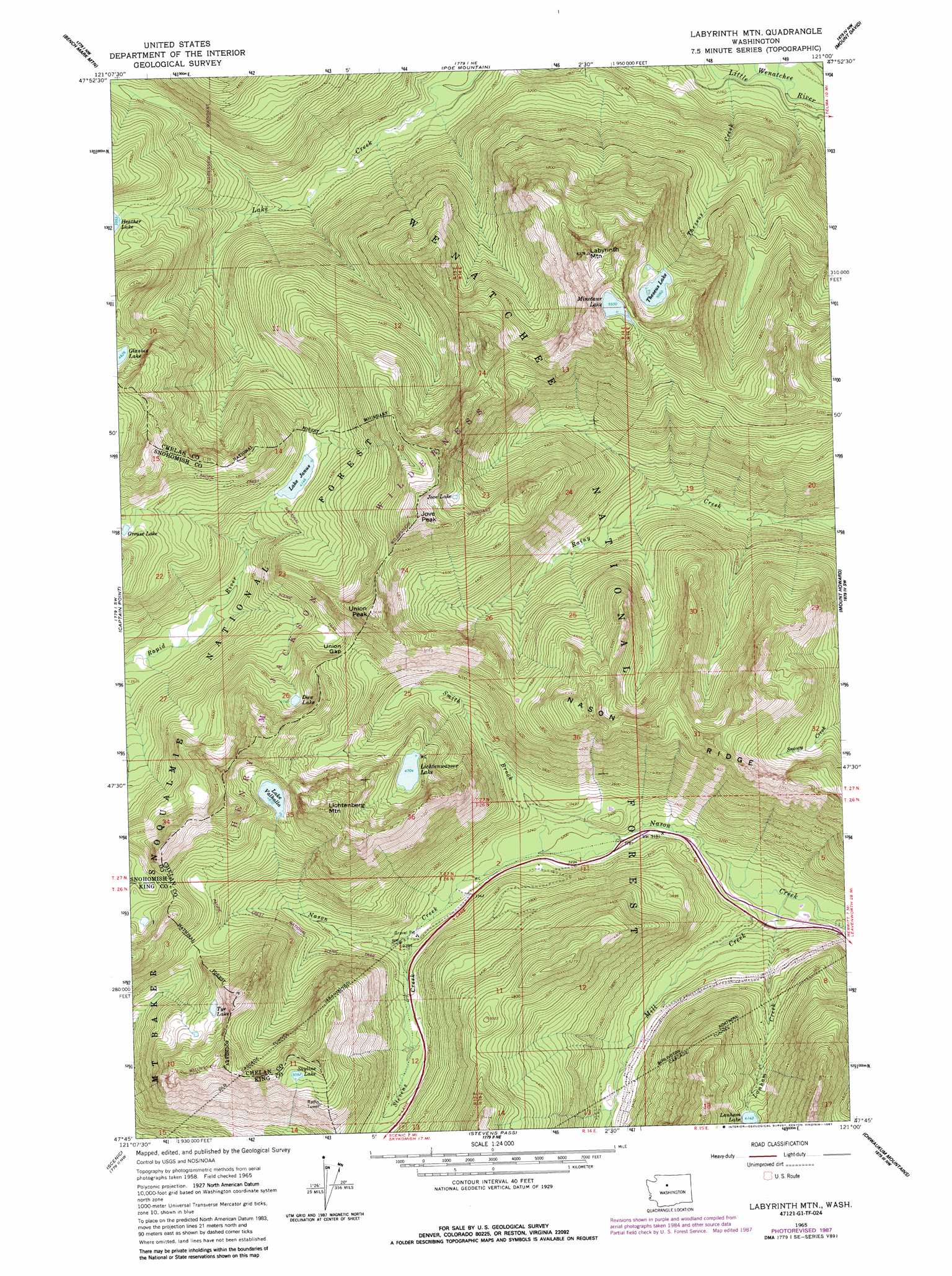
Labyrinth Mountain Topo Map Washington
To zoom in, hover over the map of Labyrinth Mountain
USGS Topo Quad 47121g1 - 1:24,000 scale
| Topo Map Name: | Labyrinth Mountain |
| USGS Topo Quad ID: | 47121g1 |
| Print Size: | ca. 21 1/4" wide x 27" high |
| Southeast Coordinates: | 47.75° N latitude / 121° W longitude |
| Map Center Coordinates: | 47.8125° N latitude / 121.0625° W longitude |
| U.S. State: | WA |
| Filename: | o47121g1.jpg |
| Download Map JPG Image: | Labyrinth Mountain topo map 1:24,000 scale |
| Map Type: | Topographic |
| Topo Series: | 7.5´ |
| Map Scale: | 1:24,000 |
| Source of Map Images: | United States Geological Survey (USGS) |
| Alternate Map Versions: |
Labyrinth Mtn WA 1965, updated 1967 Download PDF Buy paper map Labyrinth Mtn WA 1965, updated 1972 Download PDF Buy paper map Labyrinth Mtn WA 1965, updated 1981 Download PDF Buy paper map Labyrinth Mtn WA 1965, updated 1987 Download PDF Buy paper map Labyrinth Mtn WA 1965, updated 1987 Download PDF Buy paper map Labyrinth Mountain WA 2011 Download PDF Buy paper map Labyrinth Mountain WA 2014 Download PDF Buy paper map |
| FStopo: | US Forest Service topo Labyrinth Mountain is available: Download FStopo PDF Download FStopo TIF |
1:24,000 Topo Quads surrounding Labyrinth Mountain
Sloan Peak |
Glacier Peak West |
Glacier Peak East |
Clark Mountain |
Trinity |
Blanca Lake |
Benchmark Mountain |
Poe Mountain |
Mount David |
Schaefer Lake |
Evergreen Mountain |
Captain Point |
Labyrinth Mountain |
Mount Howard |
Lake Wenatchee |
Skykomish |
Scenic |
Stevens Pass |
Chiwaukum Mountains |
Big Jim Mountain |
Big Snow Mountain |
Mount Daniel |
The Cradle |
Jack Ridge |
Cashmere Mountain |
> Back to 47121e1 at 1:100,000 scale
> Back to 47120a1 at 1:250,000 scale
> Back to U.S. Topo Maps home
Labyrinth Mountain topo map: Gazetteer
Labyrinth Mountain: Gaps
Union Gap elevation 1430m 4691′Labyrinth Mountain: Lakes
Dow Lake elevation 1449m 4753′Jove Lake elevation 1575m 5167′
Lake Janus elevation 1265m 4150′
Lake Valhalla elevation 1474m 4835′
Lanham Lake elevation 1264m 4146′
Lichtenwasser Lake elevation 1435m 4708′
Minotaur Lake elevation 1693m 5554′
Skyline Lake elevation 1554m 5098′
Theseus Lake elevation 1544m 5065′
Tye Lake elevation 1427m 4681′
Labyrinth Mountain: Streams
Devils Club Creek elevation 661m 2168′Elevenmile Creek elevation 679m 2227′
Lanham Creek elevation 894m 2933′
Lodgepole Creek elevation 675m 2214′
Mill Creek elevation 882m 2893′
Smith Brook elevation 988m 3241′
Stevens Creek elevation 1028m 3372′
Theseus Creek elevation 685m 2247′
Labyrinth Mountain: Summits
Jove Peak elevation 1806m 5925′Labyrinth Mountain elevation 1907m 6256′
Lichtenberg Mountain elevation 1760m 5774′
Mount McCausland elevation 1750m 5741′
Union Peak elevation 1736m 5695′
Labyrinth Mountain: Tunnels
Old Cascade Tunnel elevation 1432m 4698′Labyrinth Mountain digital topo map on disk
Buy this Labyrinth Mountain topo map showing relief, roads, GPS coordinates and other geographical features, as a high-resolution digital map file on DVD: