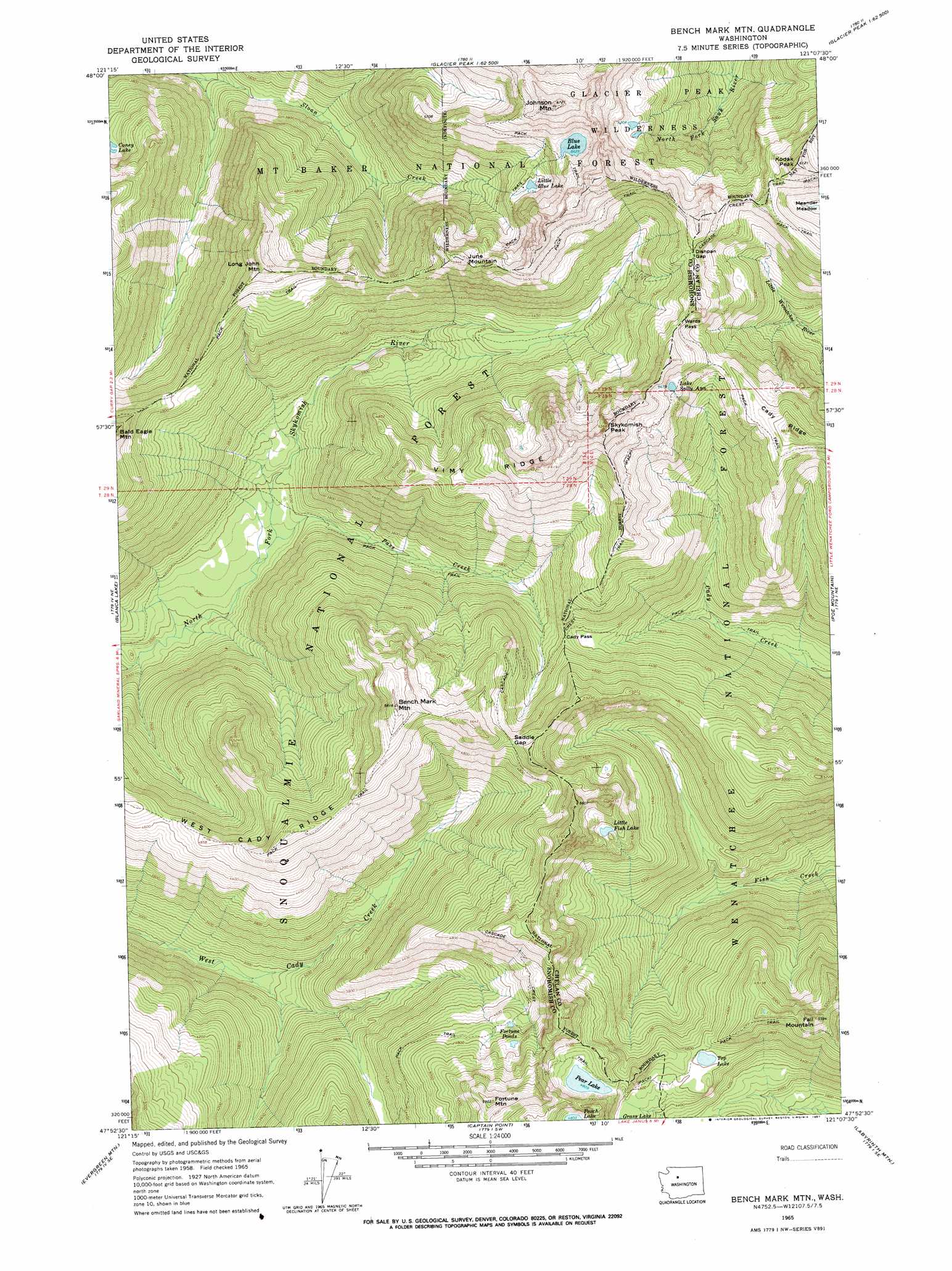
Benchmark Mountain Topo Map Washington
To zoom in, hover over the map of Benchmark Mountain
USGS Topo Quad 47121h2 - 1:24,000 scale
| Topo Map Name: | Benchmark Mountain |
| USGS Topo Quad ID: | 47121h2 |
| Print Size: | ca. 21 1/4" wide x 27" high |
| Southeast Coordinates: | 47.875° N latitude / 121.125° W longitude |
| Map Center Coordinates: | 47.9375° N latitude / 121.1875° W longitude |
| U.S. State: | WA |
| Filename: | o47121h2.jpg |
| Download Map JPG Image: | Benchmark Mountain topo map 1:24,000 scale |
| Map Type: | Topographic |
| Topo Series: | 7.5´ |
| Map Scale: | 1:24,000 |
| Source of Map Images: | United States Geological Survey (USGS) |
| Alternate Map Versions: |
Bench Mark Mtn WA 1965, updated 1967 Download PDF Buy paper map Benchmark Mountain WA 2011 Download PDF Buy paper map Benchmark Mountain WA 2014 Download PDF Buy paper map |
| FStopo: | US Forest Service topo Benchmark Mountain is available: Download FStopo PDF Download FStopo TIF |
1:24,000 Topo Quads surrounding Benchmark Mountain
White Chuck Mountain |
Pugh Mountain |
Lime Mountain |
Gamma Peak |
Suiattle Pass |
Bedal |
Sloan Peak |
Glacier Peak West |
Glacier Peak East |
Clark Mountain |
Monte Cristo |
Blanca Lake |
Benchmark Mountain |
Poe Mountain |
Mount David |
Baring |
Evergreen Mountain |
Captain Point |
Labyrinth Mountain |
Mount Howard |
Grotto |
Skykomish |
Scenic |
Stevens Pass |
Chiwaukum Mountains |
> Back to 47121e1 at 1:100,000 scale
> Back to 47120a1 at 1:250,000 scale
> Back to U.S. Topo Maps home
Benchmark Mountain topo map: Gazetteer
Benchmark Mountain: Gaps
Cady Pass elevation 1306m 4284′Dishpan Gap elevation 1701m 5580′
Saddle Gap elevation 1545m 5068′
Sauk Pass elevation 1664m 5459′
Wards Pass elevation 1741m 5711′
Benchmark Mountain: Lakes
Blue Lake elevation 1716m 5629′Fortune Ponds elevation 1493m 4898′
Lake Sally Ann elevation 1669m 5475′
Little Blue Lake elevation 1586m 5203′
Little Fish Lake elevation 1508m 4947′
Pear Lake elevation 1467m 4812′
Top Lake elevation 1401m 4596′
Benchmark Mountain: Ridges
Vimy Ridge elevation 1679m 5508′West Cady Ridge elevation 1431m 4694′
Benchmark Mountain: Streams
Pass Creek elevation 948m 3110′Benchmark Mountain: Summits
Benchmark Mountain elevation 1757m 5764′Fall Mountain elevation 1697m 5567′
Fortune Mountain elevation 1792m 5879′
Johnson Mountain elevation 2034m 6673′
June Mountain elevation 1766m 5793′
Kodak Peak elevation 1850m 6069′
Long John Mountain elevation 1714m 5623′
Skykomish Peak elevation 1889m 6197′
Benchmark Mountain digital topo map on disk
Buy this Benchmark Mountain topo map showing relief, roads, GPS coordinates and other geographical features, as a high-resolution digital map file on DVD: