Maple Valley Topo Map Washington
To zoom in, hover over the map of Maple Valley
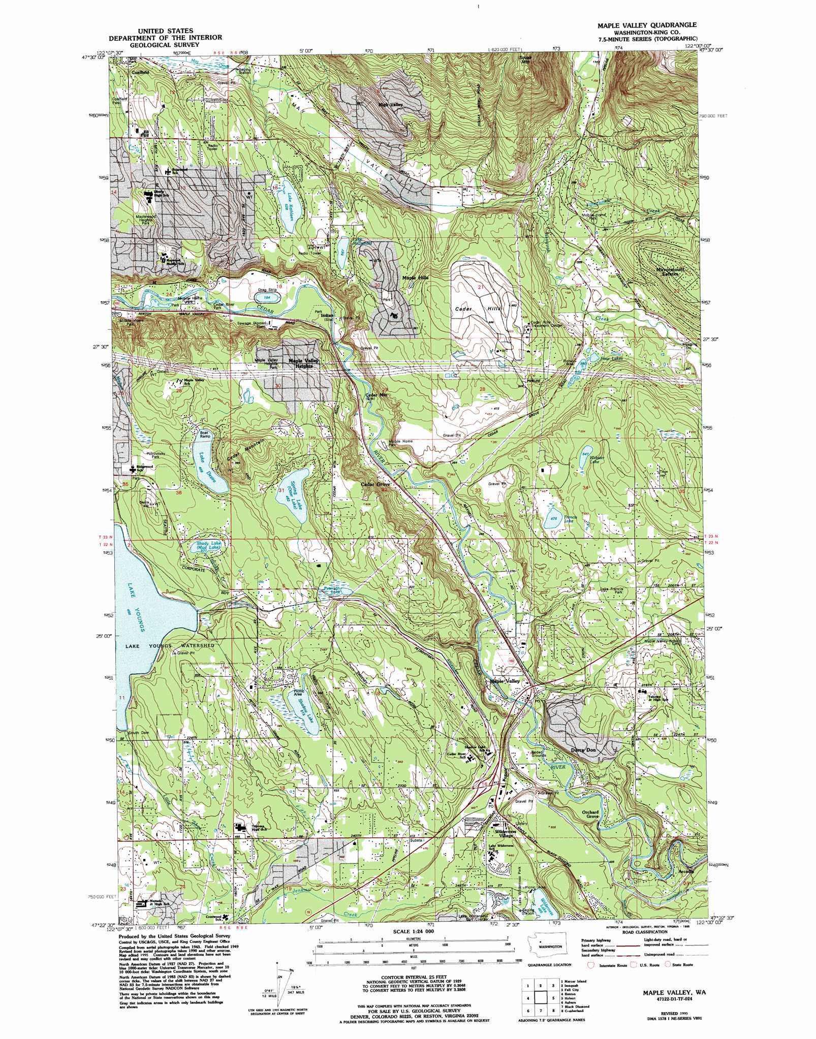
USGS Topo Quad 47122d1 - 1:24,000 scale
| Topo Map Name: | Maple Valley |
| USGS Topo Quad ID: | 47122d1 |
| Print Size: | ca. 21 1/4" wide x 27" high |
| Southeast Coordinates: | 47.375° N latitude / 122° W longitude |
| Map Center Coordinates: | 47.4375° N latitude / 122.0625° W longitude |
| U.S. State: | WA |
| Filename: | o47122d1.jpg |
| Download Map JPG Image: | Maple Valley topo map 1:24,000 scale |
| Map Type: | Topographic |
| Topo Series: | 7.5´ |
| Map Scale: | 1:24,000 |
| Source of Map Images: | United States Geological Survey (USGS) |
| Alternate Map Versions: |
Maple Valley WA 1949, updated 1956 Download PDF Buy paper map Maple Valley WA 1949, updated 1969 Download PDF Buy paper map Maple Valley WA 1949, updated 1976 Download PDF Buy paper map Maple Valley WA 1995, updated 1995 Download PDF Buy paper map Maple Valley WA 2011 Download PDF Buy paper map Maple Valley WA 2014 Download PDF Buy paper map |
1:24,000 Topo Quads surrounding Maple Valley
Seattle North |
Redmond |
Carnation |
Lake Joy |
|
Seattle South |
Issaquah |
Fall City |
Snoqualmie |
|
Des Moines |
Renton |
Maple Valley |
Hobart |
North Bend |
Poverty Bay |
Auburn |
Black Diamond |
Cumberland |
Eagle Gorge |
Puyallup |
Sumner |
Buckley |
Enumclaw |
Cyclone Creek |
> Back to 47122a1 at 1:100,000 scale
> Back to 47122a1 at 1:250,000 scale
> Back to U.S. Topo Maps home
Maple Valley topo map: Gazetteer
Maple Valley: Airports
Cedar Grove Airpark (historical) elevation 116m 380′Maple Valley: Areas
Lake Youngs Watershed elevation 153m 501′Maple Valley: Dams
Lake Youngs Inlet Dam elevation 144m 472′South Dam elevation 153m 501′
Youngs Lake Old Inlet Dam (historical) elevation 155m 508′
Maple Valley: Lakes
Four Lakes elevation 102m 334′Francis Lake elevation 144m 472′
Lake Desire elevation 150m 492′
Lake Kathleen elevation 160m 524′
Lake McDonald elevation 174m 570′
Peterson Lake elevation 140m 459′
Shadow Lake elevation 164m 538′
Shady Lake elevation 163m 534′
Spring Lake elevation 147m 482′
Webster Lake elevation 168m 551′
Wilderness Lake elevation 143m 469′
Maple Valley: Parks
Lake Francis Park elevation 145m 475′Lake Wilderness Park elevation 143m 469′
Maple Valley: Populated Places
Arcadia elevation 125m 410′Atkinson elevation 169m 554′
Cedar Grove elevation 76m 249′
Cedar Mountain elevation 66m 216′
Dorre Don elevation 106m 347′
East Renton Highlands elevation 158m 518′
High Valley elevation 190m 623′
Lake Desire elevation 178m 583′
Maple Hills elevation 201m 659′
Maple Valley elevation 128m 419′
Maple Valley Heights elevation 154m 505′
Meridian Heights elevation 155m 508′
Mirrormount Estates elevation 148m 485′
Noble elevation 140m 459′
Orchard Grove elevation 112m 367′
Tahoma elevation 161m 528′
Wilderness elevation 141m 462′
Wilderness Village elevation 136m 446′
Maple Valley: Ranges
Cedar Hills elevation 201m 659′Maple Valley: Reservoirs
Lake Youngs elevation 153m 501′Maple Valley: Streams
Fifteenmile Creek elevation 65m 213′Honey Creek elevation 163m 534′
Lions Run elevation 70m 229′
Rock Creek elevation 123m 403′
Maple Valley: Summits
Cedar Mountain elevation 265m 869′Squak Mountain elevation 471m 1545′
Maple Valley digital topo map on disk
Buy this Maple Valley topo map showing relief, roads, GPS coordinates and other geographical features, as a high-resolution digital map file on DVD: