Suquamish Topo Map Washington
To zoom in, hover over the map of Suquamish
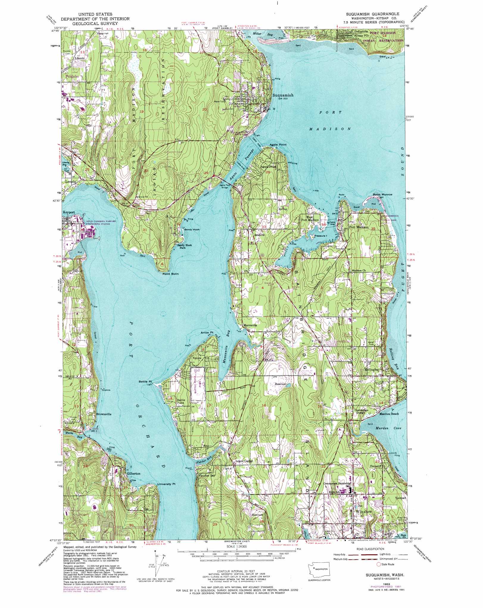
USGS Topo Quad 47122f5 - 1:24,000 scale
| Topo Map Name: | Suquamish |
| USGS Topo Quad ID: | 47122f5 |
| Print Size: | ca. 21 1/4" wide x 27" high |
| Southeast Coordinates: | 47.625° N latitude / 122.5° W longitude |
| Map Center Coordinates: | 47.6875° N latitude / 122.5625° W longitude |
| U.S. State: | WA |
| Filename: | o47122f5.jpg |
| Download Map JPG Image: | Suquamish topo map 1:24,000 scale |
| Map Type: | Topographic |
| Topo Series: | 7.5´ |
| Map Scale: | 1:24,000 |
| Source of Map Images: | United States Geological Survey (USGS) |
| Alternate Map Versions: |
Suquamish WA 1953, updated 1955 Download PDF Buy paper map Suquamish WA 1953, updated 1969 Download PDF Buy paper map Suquamish WA 1953, updated 1979 Download PDF Buy paper map Suquamish WA 1953, updated 1981 Download PDF Buy paper map Suquamish WA 1953, updated 1981 Download PDF Buy paper map Suquamish WA 1997, updated 2003 Download PDF Buy paper map Suquamish WA 2011 Download PDF Buy paper map Suquamish WA 2014 Download PDF Buy paper map |
1:24,000 Topo Quads surrounding Suquamish
Center |
Port Ludlow |
Hansville |
Maxwelton |
Mukilteo |
Quilcene |
Lofall |
Port Gamble |
Edmonds West |
Edmonds East |
Seabeck |
Poulsbo |
Suquamish |
Seattle North |
|
Wildcat Lake |
Bremerton West |
Bremerton East |
Seattle South |
|
Belfair |
Burley |
Olalla |
Vashon |
Des Moines |
> Back to 47122e1 at 1:100,000 scale
> Back to 47122a1 at 1:250,000 scale
> Back to U.S. Topo Maps home
Suquamish topo map: Gazetteer
Suquamish: Airports
Haley Heliport elevation 19m 62′Suquamish: Bars
Hedley Spit elevation -2m -7′Sandy Hook elevation 1m 3′
Suquamish: Bays
Burke Bay elevation 0m 0′Fletcher Bay elevation 0m 0′
Manzanita Bay elevation 0m 0′
Murden Cove elevation 0m 0′
Port Madison elevation 0m 0′
Port Orchard elevation 0m 0′
Rolling Bay elevation -2m -7′
Suquamish: Bridges
Agate Pass Bridge elevation 0m 0′Suquamish: Capes
Agate Point elevation 8m 26′Arrow Point elevation 8m 26′
Battle Point elevation 0m 0′
Point Bolin elevation 1m 3′
Point Monroe elevation 1m 3′
University Point elevation 3m 9′
Suquamish: Channels
Agate Passage elevation 0m 0′Suquamish: Dams
Battlepoint Park Reservoir Dam elevation 30m 98′C and H Johnson Dam Number One elevation 45m 147′
C and H Johnson Dam Number Three elevation 55m 180′
C and H Johnson Dam Number Two elevation 45m 147′
James Dam elevation 16m 52′
Koura Dam elevation 68m 223′
Owen Dam elevation 53m 173′
Suquamish: Islands
Bainbridge Island elevation 59m 193′Treasure Island elevation 6m 19′
Suquamish: Lakes
Keyport Lagoon elevation 0m 0′Suquamish: Parks
Battle Point Park elevation 45m 147′Fay-Bainbridge State Park elevation 6m 19′
Manitou Park elevation 4m 13′
Old Man House State Park elevation 11m 36′
Suquamish: Populated Places
Agate Point elevation 39m 127′Bainbridge elevation 13m 42′
Bainbridge Grange elevation 26m 85′
Bainbridge Island elevation 27m 88′
Battle Point elevation 16m 52′
Brownsville elevation 31m 101′
Ferncliff elevation 51m 167′
Fletcher Bay elevation 20m 65′
Gilberton elevation 37m 121′
Hawley elevation 13m 42′
Indianola elevation 14m 45′
Kariotis elevation 123m 403′
Keyport elevation 15m 49′
Lemolo elevation 9m 29′
Lincoln elevation 118m 387′
Madrona Heights elevation 29m 95′
Manitou Beach elevation 2m 6′
Manzanita elevation 1m 3′
Port Madison elevation 24m 78′
Rollingbay elevation 52m 170′
Seabold elevation 60m 196′
Suquamish elevation 21m 68′
Tolo elevation 8m 26′
Treemont elevation 112m 367′
Trikkala elevation 119m 390′
Venice elevation 35m 114′
West Port Madison elevation 5m 16′
Suquamish: Post Offices
Indianola Post Office elevation 15m 49′Kitsap Post Office elevation 13m 42′
Suquamish Post Office elevation 17m 55′
Suquamish: Reservoirs
Battlepoint Park Reservoir elevation 30m 98′Erickson Reservoir elevation 18m 59′
Suquamish: Streams
Bjorgen Creek elevation 2m 6′Issei Creek elevation 3m 9′
Manzanita Creek elevation 9m 29′
Miemois Creek elevation 1m 3′
Suquamish digital topo map on disk
Buy this Suquamish topo map showing relief, roads, GPS coordinates and other geographical features, as a high-resolution digital map file on DVD: