Brinnon Topo Map Washington
To zoom in, hover over the map of Brinnon
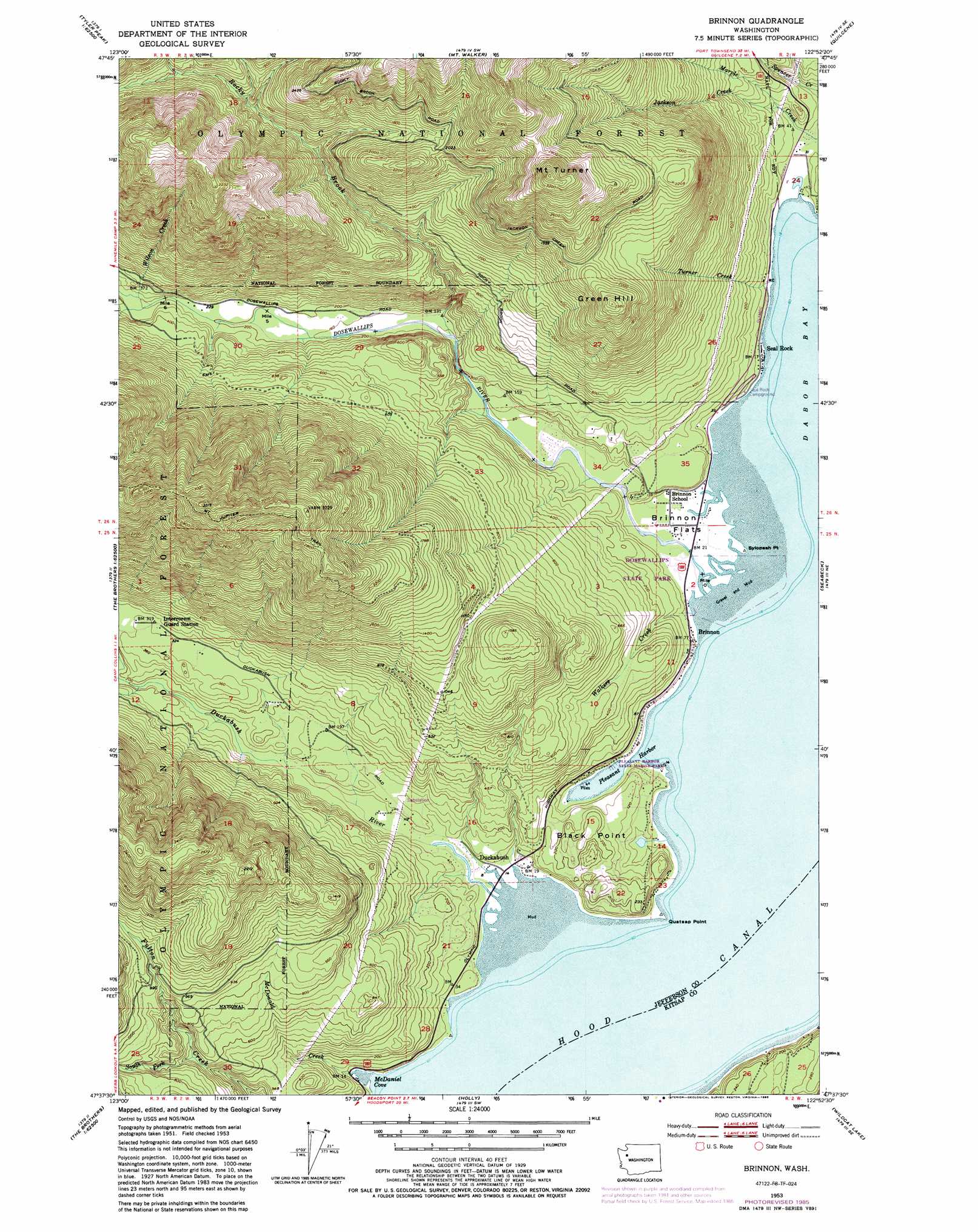
USGS Topo Quad 47122f8 - 1:24,000 scale
| Topo Map Name: | Brinnon |
| USGS Topo Quad ID: | 47122f8 |
| Print Size: | ca. 21 1/4" wide x 27" high |
| Southeast Coordinates: | 47.625° N latitude / 122.875° W longitude |
| Map Center Coordinates: | 47.6875° N latitude / 122.9375° W longitude |
| U.S. State: | WA |
| Filename: | o47122f8.jpg |
| Download Map JPG Image: | Brinnon topo map 1:24,000 scale |
| Map Type: | Topographic |
| Topo Series: | 7.5´ |
| Map Scale: | 1:24,000 |
| Source of Map Images: | United States Geological Survey (USGS) |
| Alternate Map Versions: |
Brinnon WA 1953, updated 1955 Download PDF Buy paper map Brinnon WA 1953, updated 1971 Download PDF Buy paper map Brinnon WA 1953, updated 1978 Download PDF Buy paper map Brinnon WA 1953, updated 1981 Download PDF Buy paper map Brinnon WA 1953, updated 1985 Download PDF Buy paper map Brinnon WA 1999, updated 2001 Download PDF Buy paper map Brinnon WA 2011 Download PDF Buy paper map Brinnon WA 2014 Download PDF Buy paper map |
| FStopo: | US Forest Service topo Brinnon is available: Download FStopo PDF Download FStopo TIF |
1:24,000 Topo Quads surrounding Brinnon
Tyler Peak |
Mount Zion |
Uncas |
Center |
Port Ludlow |
Mount Deception |
Mount Townsend |
Mount Walker |
Quilcene |
Lofall |
The Brothers |
Mount Jupiter |
Brinnon |
Seabeck |
Poulsbo |
Mount Washington |
Eldon |
Holly |
Wildcat Lake |
Bremerton West |
Hoodsport |
Lilliwaup |
Lake Wooten |
Belfair |
Burley |
> Back to 47122e1 at 1:100,000 scale
> Back to 47122a1 at 1:250,000 scale
> Back to U.S. Topo Maps home
Brinnon topo map: Gazetteer
Brinnon: Bars
Dosewallips Flats elevation 2m 6′Brinnon: Bays
McDaniel Cove elevation 0m 0′Pleasant Harbor elevation 1m 3′
Right Smart Cove elevation 2m 6′
Brinnon: Capes
Black Point elevation 63m 206′Boston Point elevation 0m 0′
Quatsap Point elevation 0m 0′
Sylopash Point elevation 2m 6′
Brinnon: Flats
Brinnon Flats elevation 6m 19′Brinnon: Parks
Dosewallips State Park elevation 44m 144′Pleasant Harbor State Marine Park elevation 1m 3′
Brinnon: Populated Places
Brinnon elevation 12m 39′Duckabush elevation 7m 22′
Lackawanna Beach elevation 11m 36′
Seal Rock elevation 3m 9′
Brinnon: Streams
Dosewallips River elevation 3m 9′Duckabush River elevation 3m 9′
Jackson Creek elevation 26m 85′
Marple Creek elevation 2m 6′
McDonald Creek elevation 3m 9′
Rocky Brook elevation 32m 104′
South Fork Fulton Creek elevation 133m 436′
Spencer Creek elevation 3m 9′
Turner Creek elevation 2m 6′
Walkers Creek elevation 3m 9′
Wilson Creek elevation 79m 259′
Brinnon: Summits
Green Hill elevation 725m 2378′Mount Turner elevation 1025m 3362′
Brinnon: Trails
Mount Jupiter Trail elevation 983m 3225′Brinnon digital topo map on disk
Buy this Brinnon topo map showing relief, roads, GPS coordinates and other geographical features, as a high-resolution digital map file on DVD: