Mukilteo Topo Map Washington
To zoom in, hover over the map of Mukilteo
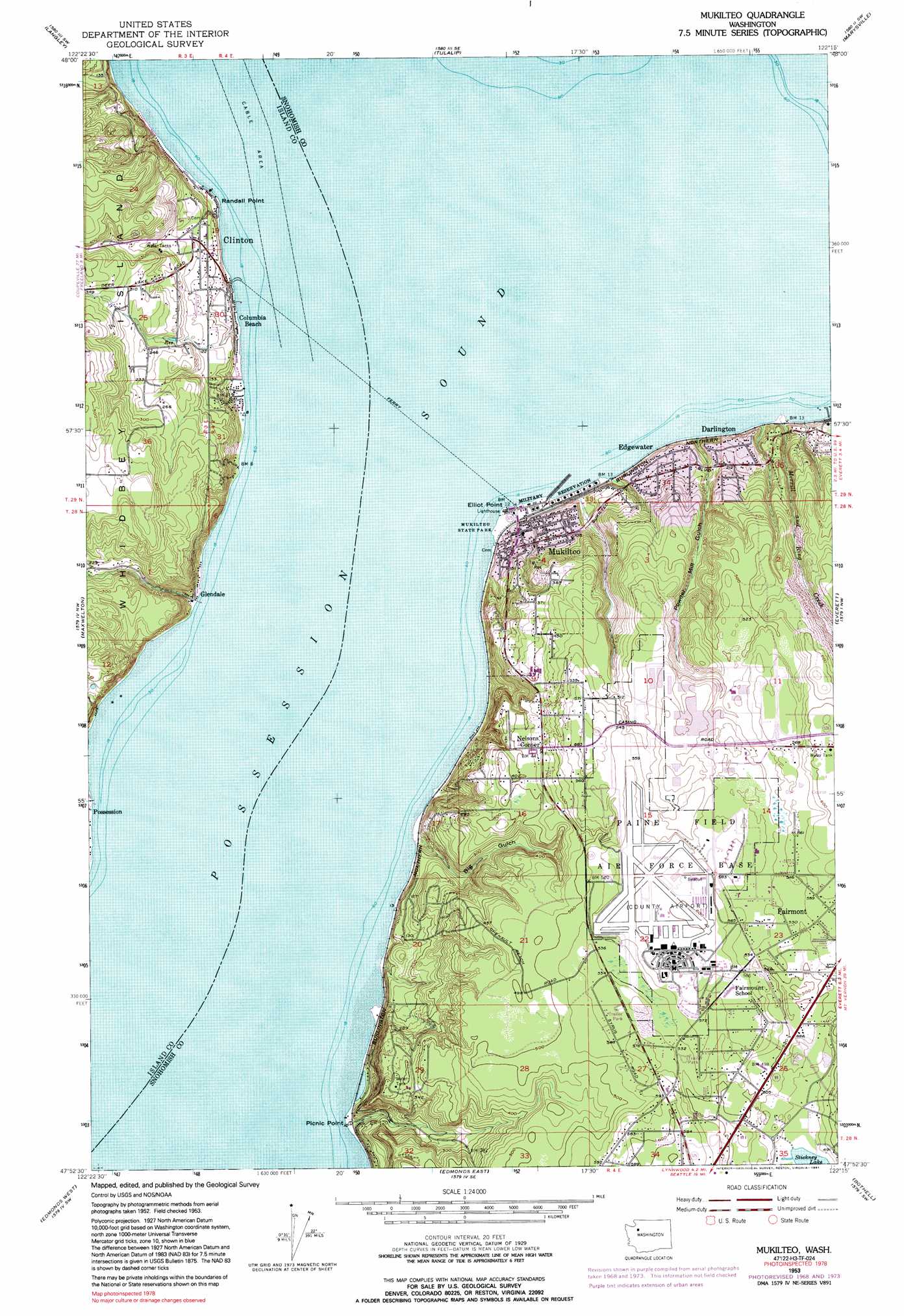
USGS Topo Quad 47122h3 - 1:24,000 scale
| Topo Map Name: | Mukilteo |
| USGS Topo Quad ID: | 47122h3 |
| Print Size: | ca. 21 1/4" wide x 27" high |
| Southeast Coordinates: | 47.875° N latitude / 122.25° W longitude |
| Map Center Coordinates: | 47.9375° N latitude / 122.3125° W longitude |
| U.S. State: | WA |
| Filename: | o47122h3.jpg |
| Download Map JPG Image: | Mukilteo topo map 1:24,000 scale |
| Map Type: | Topographic |
| Topo Series: | 7.5´ |
| Map Scale: | 1:24,000 |
| Source of Map Images: | United States Geological Survey (USGS) |
| Alternate Map Versions: |
Mukilteo WA 1953, updated 1955 Download PDF Buy paper map Mukilteo WA 1953, updated 1967 Download PDF Buy paper map Mukilteo WA 1953, updated 1969 Download PDF Buy paper map Mukilteo WA 1953, updated 1976 Download PDF Buy paper map Mukilteo WA 1953, updated 1991 Download PDF Buy paper map Mukilteo WA 2011 Download PDF Buy paper map Mukilteo WA 2014 Download PDF Buy paper map |
1:24,000 Topo Quads surrounding Mukilteo
Camano |
Juniper Beach |
Stanwood |
Arlington West |
Arlington East |
Freeland |
Langley |
Tulalip |
Marysville |
Lake Stevens |
Hansville |
Maxwelton |
Mukilteo |
Everett |
Snohomish |
Port Gamble |
Edmonds West |
Edmonds East |
Bothell |
Maltby |
Suquamish |
Seattle North |
Redmond |
> Back to 47122e1 at 1:100,000 scale
> Back to 47122a1 at 1:250,000 scale
> Back to U.S. Topo Maps home
Mukilteo topo map: Gazetteer
Mukilteo: Airports
Boeing-Everett Ramp Site 2 Heliport elevation 174m 570′Snohomish County Airport elevation 179m 587′
Mukilteo: Capes
Elliot Point elevation 0m 0′Picnic Point elevation 2m 6′
Randall Point elevation 2m 6′
Mukilteo: Crossings
Airport Road Interchange elevation 173m 567′Twentieth Avenue West Interchange elevation 173m 567′
Mukilteo: Dams
Boeing Flood Control Dam elevation 117m 383′Orrs Pond Dam elevation 55m 180′
Mukilteo: Lakes
Picnic Point Lake elevation 1m 3′Mukilteo: Parks
Mukilteo State Park elevation 2m 6′Mukilteo: Populated Places
Clinton elevation 40m 131′Columbia Beach elevation 10m 32′
Darlington elevation 61m 200′
Edgewater elevation 49m 160′
Fairmont elevation 166m 544′
Glendale elevation 13m 42′
Harbour Pointe elevation 153m 501′
Lake Stickney elevation 142m 465′
Mukilteo elevation 32m 104′
Nelsons Corner elevation 135m 442′
Picnic Point elevation 24m 78′
Mukilteo: Reservoirs
Orrs Pond elevation 55m 180′Powder Mill Gulch Retention Basin elevation 117m 383′
Mukilteo: Streams
Merrill and Ring Creek elevation 2m 6′Mukilteo: Valleys
Big Gulch elevation 2m 6′Japanese Gulch elevation 2m 6′
Powder Mill Gulch elevation 4m 13′
Mukilteo digital topo map on disk
Buy this Mukilteo topo map showing relief, roads, GPS coordinates and other geographical features, as a high-resolution digital map file on DVD: