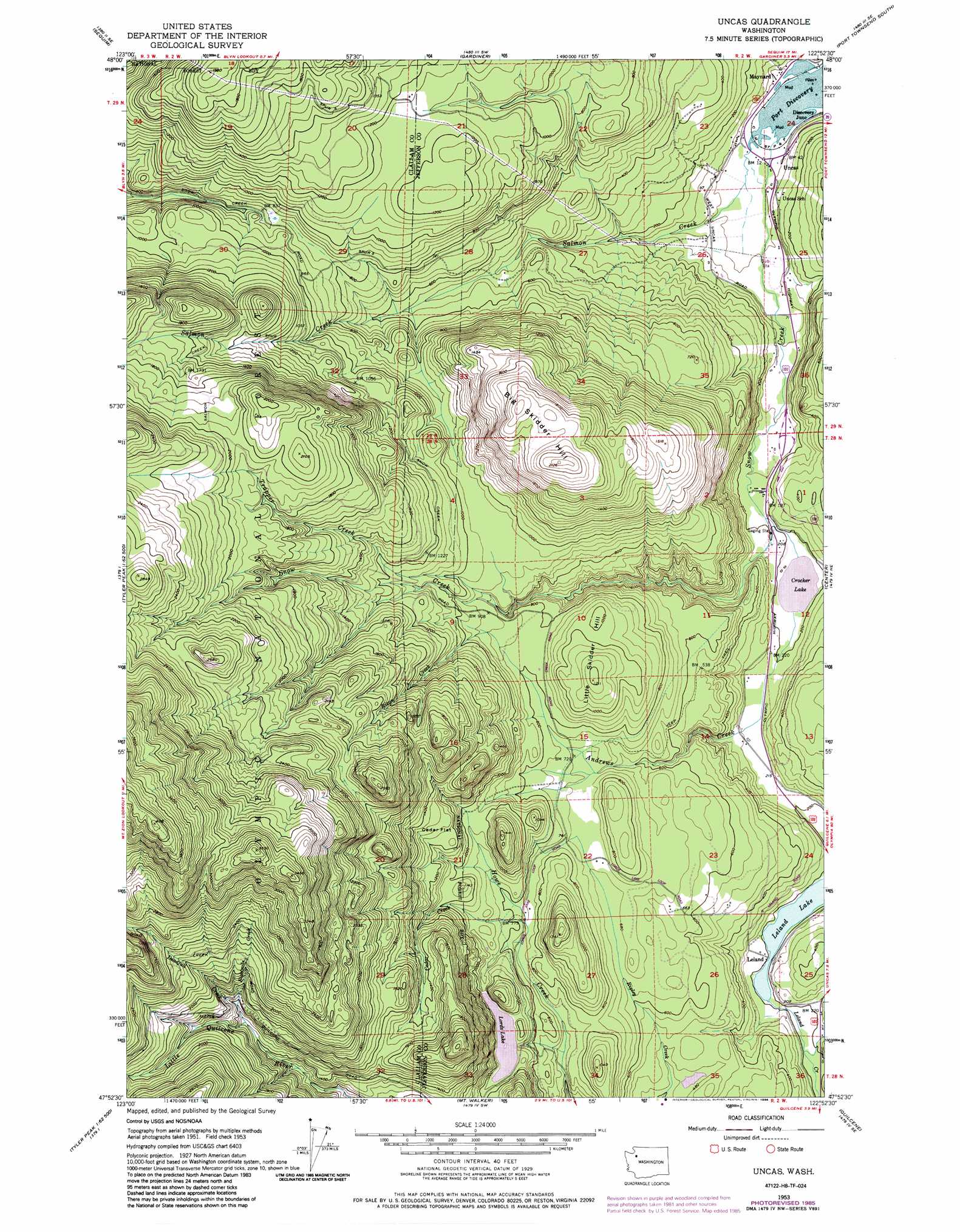
Uncas Topo Map Washington
To zoom in, hover over the map of Uncas
USGS Topo Quad 47122h8 - 1:24,000 scale
| Topo Map Name: | Uncas |
| USGS Topo Quad ID: | 47122h8 |
| Print Size: | ca. 21 1/4" wide x 27" high |
| Southeast Coordinates: | 47.875° N latitude / 122.875° W longitude |
| Map Center Coordinates: | 47.9375° N latitude / 122.9375° W longitude |
| U.S. State: | WA |
| Filename: | o47122h8.jpg |
| Download Map JPG Image: | Uncas topo map 1:24,000 scale |
| Map Type: | Topographic |
| Topo Series: | 7.5´ |
| Map Scale: | 1:24,000 |
| Source of Map Images: | United States Geological Survey (USGS) |
| Alternate Map Versions: |
Uncas WA 1953, updated 1955 Download PDF Buy paper map Uncas WA 1953, updated 1964 Download PDF Buy paper map Uncas WA 1953, updated 1976 Download PDF Buy paper map Uncas WA 1953, updated 1986 Download PDF Buy paper map Uncas WA 1995, updated 1998 Download PDF Buy paper map Uncas WA 2011 Download PDF Buy paper map Uncas WA 2014 Download PDF Buy paper map |
| FStopo: | US Forest Service topo Uncas is available: Download FStopo PDF Download FStopo TIF |
1:24,000 Topo Quads surrounding Uncas
Dungeness |
Port Townsend North |
Coupeville |
||
Carlsborg |
Sequim |
Gardiner |
Port Townsend South |
Nordland |
Tyler Peak |
Mount Zion |
Uncas |
Center |
Port Ludlow |
Mount Deception |
Mount Townsend |
Mount Walker |
Quilcene |
Lofall |
The Brothers |
Mount Jupiter |
Brinnon |
Seabeck |
Poulsbo |
> Back to 47122e1 at 1:100,000 scale
> Back to 47122a1 at 1:250,000 scale
> Back to U.S. Topo Maps home
Uncas topo map: Gazetteer
Uncas: Bays
Discovery Bay elevation 0m 0′Uncas: Dams
Lords Lake East Dam elevation 293m 961′Lords Lake North Dam elevation 304m 997′
Uncas: Flats
Cedar Flat elevation 399m 1309′Uncas: Lakes
Crocker Lake elevation 59m 193′Leland Lake elevation 60m 196′
Uncas: Populated Places
Discovery Bay elevation 15m 49′Leland elevation 63m 206′
Maynard elevation 5m 16′
Uncas elevation 23m 75′
Uncas: Reservoirs
Lords Lake elevation 304m 997′Uncas: Streams
Andrews Creek elevation 58m 190′Cedar Creek elevation 236m 774′
Deadfall Creek elevation 446m 1463′
Eightmile Creek elevation 476m 1561′
Rixon Creek elevation 271m 889′
Salmon Creek elevation 3m 9′
Snow Creek elevation 2m 6′
Trapper Creek elevation 267m 875′
Uncas: Summits
Big Skidder Hill elevation 646m 2119′Little Skidder Hill elevation 371m 1217′
Mount Chatham elevation 632m 2073′
Uncas: Trails
Deadfall Trail elevation 778m 2552′Mount Zion Trail (historical) elevation 1068m 3503′
Uncas digital topo map on disk
Buy this Uncas topo map showing relief, roads, GPS coordinates and other geographical features, as a high-resolution digital map file on DVD: