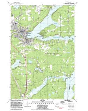
Shelton Topo Map Washington
To zoom in, hover over the map of Shelton
USGS Topo Quad 47123b1 - 1:24,000 scale
| Topo Map Name: | Shelton |
| USGS Topo Quad ID: | 47123b1 |
| Print Size: | ca. 21 1/4" wide x 27" high |
| Southeast Coordinates: | 47.125° N latitude / 123° W longitude |
| Map Center Coordinates: | 47.1875° N latitude / 123.0625° W longitude |
| U.S. State: | WA |
| Filename: | o47123b1.jpg |
| Download Map JPG Image: | Shelton topo map 1:24,000 scale |
| Map Type: | Topographic |
| Topo Series: | 7.5´ |
| Map Scale: | 1:24,000 |
| Source of Map Images: | United States Geological Survey (USGS) |
| Alternate Map Versions: |
Shelton WA 1981, updated 1982 Download PDF Buy paper map Shelton WA 1981, updated 1982 Download PDF Buy paper map Shelton WA 2011 Download PDF Buy paper map Shelton WA 2014 Download PDF Buy paper map |
1:24,000 Topo Quads surrounding Shelton
> Back to 47123a1 at 1:100,000 scale
> Back to 47122a1 at 1:250,000 scale
> Back to U.S. Topo Maps home
Shelton topo map: Gazetteer
Shelton: Airports
Mason General Hospital Heliport elevation 66m 216′Shelton: Bays
Big Cove elevation 2m 6′Brown Cove elevation 1m 3′
Chapman Cove elevation 1m 3′
Deer Harbor elevation 1m 3′
Hammersley Inlet elevation 1m 3′
Hudson Cove elevation 3m 9′
Little Skookum Inlet elevation 3m 9′
Lower Lynch Cove elevation 1m 3′
Oakland Bay elevation 0m 0′
Upper Lynch Cove elevation 5m 16′
Wildcat Cove elevation 1m 3′
Shelton: Capes
Baron Point elevation 2m 6′Church Point elevation 1m 3′
Cougar Point elevation 3m 9′
Eagle Point elevation 1m 3′
Kamilche Point elevation 1m 3′
Miller Point elevation 1m 3′
Mud Cat Point elevation 1m 3′
Munson Point elevation 6m 19′
Quarters Point elevation 3m 9′
Skookum Point elevation 1m 3′
Shelton: Dams
Fawn Lake Dam elevation 51m 167′Shelton: Flats
Johns Prairie elevation 65m 213′Shelton: Guts
The Narrows elevation 1m 3′Shelton: Lakes
Isabella Lake elevation 36m 118′Island Lake elevation 70m 229′
Shelton: Parks
Jacobys Shorecrest County Park elevation 10m 32′Shelton: Pillars
Tillicum Rock elevation 1m 3′Shelton: Populated Places
Agate elevation 37m 121′Bayshore elevation 8m 26′
Carmill Station elevation 71m 232′
Elizan Beach elevation 18m 59′
Kamilche elevation 17m 55′
Oakland elevation 1m 3′
Shelton elevation 7m 22′
Shelton: Reservoirs
Fawn Lake elevation 51m 167′Shelton: Springs
Shelton Springs elevation 66m 216′Shelton: Streams
Campbell Creek elevation 6m 19′Coffee Creek elevation 88m 288′
Deer Creek elevation 8m 26′
Elson Creek elevation 1m 3′
Goldsborough Creek elevation 5m 16′
Johns Creek elevation 2m 6′
Little Skookum Creek elevation 8m 26′
Lynch Creek elevation 1m 3′
Mable Taylor Creek elevation 13m 42′
Shelton Creek elevation 9m 29′
Skookum Creek elevation 3m 9′
Uncle John Creek elevation 4m 13′
Shelton digital topo map on disk
Buy this Shelton topo map showing relief, roads, GPS coordinates and other geographical features, as a high-resolution digital map file on DVD:


