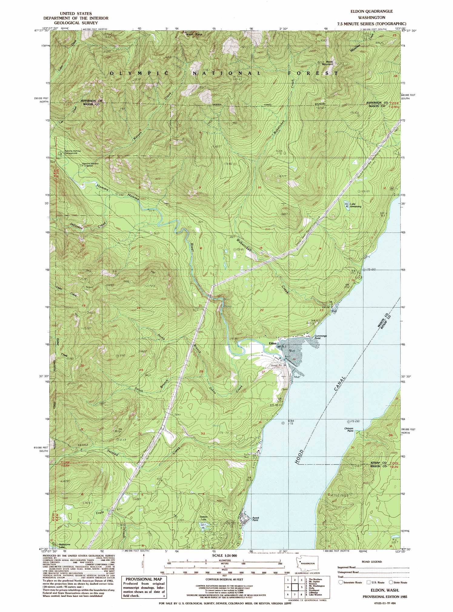
Eldon Topo Map Washington
To zoom in, hover over the map of Eldon
USGS Topo Quad 47123e1 - 1:24,000 scale
| Topo Map Name: | Eldon |
| USGS Topo Quad ID: | 47123e1 |
| Print Size: | ca. 21 1/4" wide x 27" high |
| Southeast Coordinates: | 47.5° N latitude / 123° W longitude |
| Map Center Coordinates: | 47.5625° N latitude / 123.0625° W longitude |
| U.S. State: | WA |
| Filename: | o47123e1.jpg |
| Download Map JPG Image: | Eldon topo map 1:24,000 scale |
| Map Type: | Topographic |
| Topo Series: | 7.5´ |
| Map Scale: | 1:24,000 |
| Source of Map Images: | United States Geological Survey (USGS) |
| Alternate Map Versions: |
Eldon WA 1985, updated 1985 Download PDF Buy paper map Eldon WA 2011 Download PDF Buy paper map Eldon WA 2014 Download PDF Buy paper map |
| FStopo: | US Forest Service topo Eldon is available: Download FStopo PDF Download FStopo TIF |
1:24,000 Topo Quads surrounding Eldon
Wellesley Peak |
Mount Deception |
Mount Townsend |
Mount Walker |
Quilcene |
Mount Steel |
The Brothers |
Mount Jupiter |
Brinnon |
Seabeck |
Mount Skokomish |
Mount Washington |
Eldon |
Holly |
Wildcat Lake |
Lightning Peak |
Hoodsport |
Lilliwaup |
Lake Wooten |
Belfair |
Vance Creek |
Skokomish Valley |
Union |
Mason Lake |
Vaughn |
> Back to 47123e1 at 1:100,000 scale
> Back to 47122a1 at 1:250,000 scale
> Back to U.S. Topo Maps home
Eldon topo map: Gazetteer
Eldon: Capes
Ayock Point elevation 4m 13′Chinom Point elevation 3m 9′
Cummings Point elevation 12m 39′
Eldon: Lakes
Lake Armstrong elevation 200m 656′Stetson Lake elevation 161m 528′
Eldon: Pillars
Capstan Rock elevation 12m 39′Eldon: Populated Places
Ayock elevation 7m 22′Eldon elevation 9m 29′
Hamma Hamma elevation 21m 68′
Eldon: Streams
Hamma Hamma River elevation 2m 6′Jefferson Creek elevation 158m 518′
John Creek elevation 7m 22′
Jorsted Creek elevation 2m 6′
North Fork John Creek elevation 41m 134′
South Fork John Creek elevation 41m 134′
Waketickeh Creek elevation 4m 13′
Watson Creek elevation 162m 531′
Eldon: Summits
Webb Mountain elevation 841m 2759′West Rock elevation 1223m 4012′
Eldon digital topo map on disk
Buy this Eldon topo map showing relief, roads, GPS coordinates and other geographical features, as a high-resolution digital map file on DVD: