Mount Jupiter Topo Map Washington
To zoom in, hover over the map of Mount Jupiter
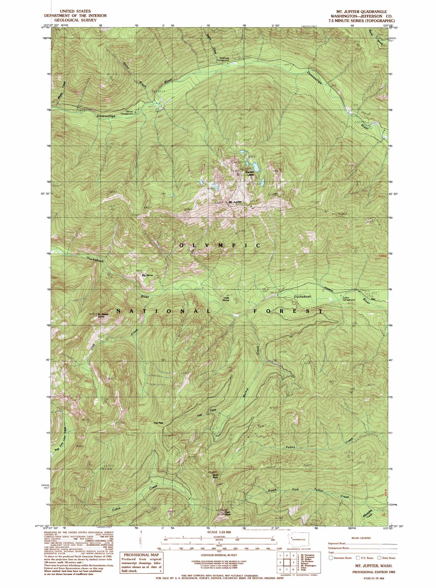
USGS Topo Quad 47123f1 - 1:24,000 scale
| Topo Map Name: | Mount Jupiter |
| USGS Topo Quad ID: | 47123f1 |
| Print Size: | ca. 21 1/4" wide x 27" high |
| Southeast Coordinates: | 47.625° N latitude / 123° W longitude |
| Map Center Coordinates: | 47.6875° N latitude / 123.0625° W longitude |
| U.S. State: | WA |
| Filename: | o47123f1.jpg |
| Download Map JPG Image: | Mount Jupiter topo map 1:24,000 scale |
| Map Type: | Topographic |
| Topo Series: | 7.5´ |
| Map Scale: | 1:24,000 |
| Source of Map Images: | United States Geological Survey (USGS) |
| Alternate Map Versions: |
Mt Jupiter WA 1985, updated 1985 Download PDF Buy paper map Mount Jupiter WA 2011 Download PDF Buy paper map Mount Jupiter WA 2014 Download PDF Buy paper map |
| FStopo: | US Forest Service topo Mount Jupiter is available: Download FStopo PDF Download FStopo TIF |
1:24,000 Topo Quads surrounding Mount Jupiter
Maiden Peak |
Tyler Peak |
Mount Zion |
Uncas |
Center |
Wellesley Peak |
Mount Deception |
Mount Townsend |
Mount Walker |
Quilcene |
Mount Steel |
The Brothers |
Mount Jupiter |
Brinnon |
Seabeck |
Mount Skokomish |
Mount Washington |
Eldon |
Holly |
Wildcat Lake |
Lightning Peak |
Hoodsport |
Lilliwaup |
Lake Wooten |
Belfair |
> Back to 47123e1 at 1:100,000 scale
> Back to 47122a1 at 1:250,000 scale
> Back to U.S. Topo Maps home
Mount Jupiter topo map: Gazetteer
Mount Jupiter: Gaps
Trap Pass elevation 1148m 3766′Mount Jupiter: Lakes
Jupiter Lakes elevation 1164m 3818′Mount Jupiter: Streams
Cliff Creek elevation 243m 797′Gamm Creek elevation 160m 524′
Milwaukee Creek elevation 274m 898′
Miners Creek elevation 306m 1003′
Murhut Creek elevation 181m 593′
Stony Brook elevation 203m 666′
Trap Creek elevation 668m 2191′
Mount Jupiter: Summits
Big Hump elevation 543m 1781′East Rock elevation 1287m 4222′
Jupiter Hills elevation 1443m 4734′
Little Hump elevation 298m 977′
Mount Jupiter elevation 1694m 5557′
North Rock elevation 1231m 4038′
Saint Peters Dome elevation 1313m 4307′
Mount Jupiter digital topo map on disk
Buy this Mount Jupiter topo map showing relief, roads, GPS coordinates and other geographical features, as a high-resolution digital map file on DVD: