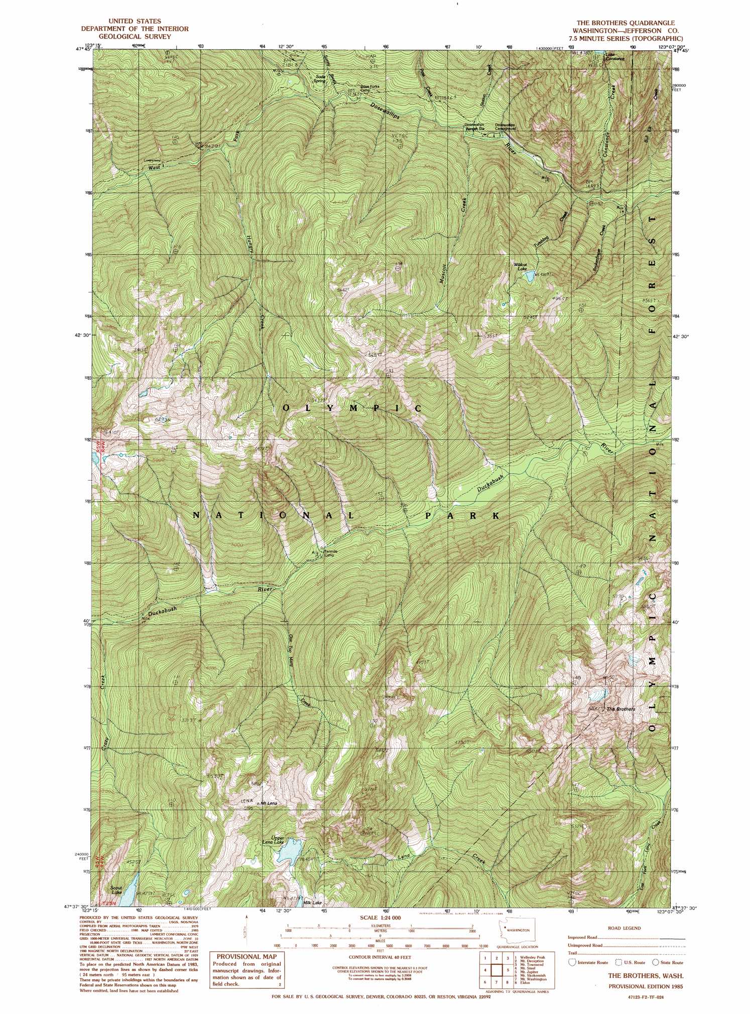
The Brothers Topo Map Washington
To zoom in, hover over the map of The Brothers
USGS Topo Quad 47123f2 - 1:24,000 scale
| Topo Map Name: | The Brothers |
| USGS Topo Quad ID: | 47123f2 |
| Print Size: | ca. 21 1/4" wide x 27" high |
| Southeast Coordinates: | 47.625° N latitude / 123.125° W longitude |
| Map Center Coordinates: | 47.6875° N latitude / 123.1875° W longitude |
| U.S. State: | WA |
| Filename: | o47123f2.jpg |
| Download Map JPG Image: | The Brothers topo map 1:24,000 scale |
| Map Type: | Topographic |
| Topo Series: | 7.5´ |
| Map Scale: | 1:24,000 |
| Source of Map Images: | United States Geological Survey (USGS) |
| Alternate Map Versions: |
The Brothers WA 1985, updated 1985 Download PDF Buy paper map The Brothers WA 1985, updated 1985 Download PDF Buy paper map The Brothers WA 2011 Download PDF Buy paper map The Brothers WA 2014 Download PDF Buy paper map |
| FStopo: | US Forest Service topo The Brothers is available: Download FStopo PDF Download FStopo TIF |
1:24,000 Topo Quads surrounding The Brothers
Mount Angeles |
Maiden Peak |
Tyler Peak |
Mount Zion |
Uncas |
Mccartney Peak |
Wellesley Peak |
Mount Deception |
Mount Townsend |
Mount Walker |
Chimney Peak |
Mount Steel |
The Brothers |
Mount Jupiter |
Brinnon |
Mount Olsen |
Mount Skokomish |
Mount Washington |
Eldon |
Holly |
Mount Tebo |
Lightning Peak |
Hoodsport |
Lilliwaup |
Lake Wooten |
> Back to 47123e1 at 1:100,000 scale
> Back to 47122a1 at 1:250,000 scale
> Back to U.S. Topo Maps home
The Brothers topo map: Gazetteer
The Brothers: Lakes
Scout Lake elevation 1299m 4261′Wildcat Lake elevation 1272m 4173′
The Brothers: Springs
Soda Springs elevation 615m 2017′The Brothers: Streams
Brokenfinger Creek elevation 367m 1204′Bull Elk Creek elevation 302m 990′
Constance Creek elevation 354m 1161′
Crazy Creek elevation 617m 2024′
Hungry Creek elevation 663m 2175′
Muscott Creek elevation 484m 1587′
One Too Many Creek elevation 482m 1581′
Pass Creek elevation 504m 1653′
Station Creek elevation 487m 1597′
Sunny Brook elevation 547m 1794′
Tumbling Creek elevation 405m 1328′
West Fork Dosewallips River elevation 594m 1948′
The Brothers: Summits
Mount Lena elevation 1743m 5718′The Brothers elevation 2019m 6624′
The Brothers: Valleys
Bull Elk Canyon elevation 371m 1217′The Brothers digital topo map on disk
Buy this The Brothers topo map showing relief, roads, GPS coordinates and other geographical features, as a high-resolution digital map file on DVD: