Chimney Peak Topo Map Washington
To zoom in, hover over the map of Chimney Peak
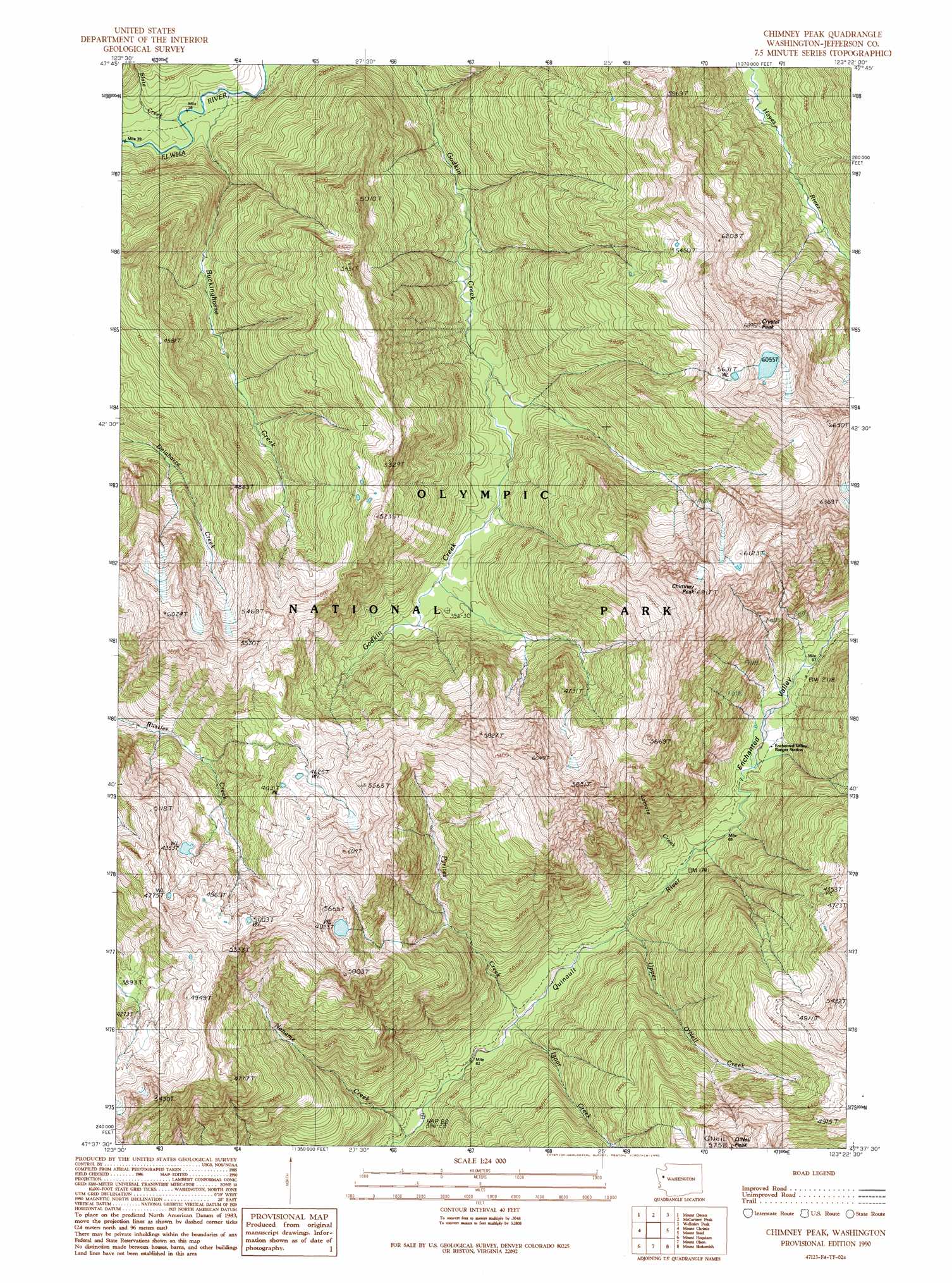
USGS Topo Quad 47123f4 - 1:24,000 scale
| Topo Map Name: | Chimney Peak |
| USGS Topo Quad ID: | 47123f4 |
| Print Size: | ca. 21 1/4" wide x 27" high |
| Southeast Coordinates: | 47.625° N latitude / 123.375° W longitude |
| Map Center Coordinates: | 47.6875° N latitude / 123.4375° W longitude |
| U.S. State: | WA |
| Filename: | o47123f4.jpg |
| Download Map JPG Image: | Chimney Peak topo map 1:24,000 scale |
| Map Type: | Topographic |
| Topo Series: | 7.5´ |
| Map Scale: | 1:24,000 |
| Source of Map Images: | United States Geological Survey (USGS) |
| Alternate Map Versions: |
Chimney Peak WA 1990, updated 1990 Download PDF Buy paper map Chimney Peak WA 2011 Download PDF Buy paper map Chimney Peak WA 2014 Download PDF Buy paper map |
1:24,000 Topo Quads surrounding Chimney Peak
Mount Carrie |
Hurricane Hill |
Mount Angeles |
Maiden Peak |
Tyler Peak |
Mount Olympus |
Mount Queets |
Mccartney Peak |
Wellesley Peak |
Mount Deception |
Kimta Peak |
Mount Christie |
Chimney Peak |
Mount Steel |
The Brothers |
Bunch Lake |
Mount Hoquiam |
Mount Olsen |
Mount Skokomish |
Mount Washington |
Colonel Bob |
Wynoochee Lake |
Mount Tebo |
Lightning Peak |
Hoodsport |
> Back to 47123e1 at 1:100,000 scale
> Back to 47122a1 at 1:250,000 scale
> Back to U.S. Topo Maps home
Chimney Peak topo map: Gazetteer
Chimney Peak: Streams
Buckinghorse Creek elevation 616m 2020′Ignar Creek elevation 445m 1459′
Lamata Creek elevation 535m 1755′
Noname Creek elevation 404m 1325′
Pyrites Creek elevation 439m 1440′
Slate Creek elevation 634m 2080′
Upper O'Neil Creek elevation 486m 1594′
Chimney Peak: Summits
Chimney Peak elevation 2086m 6843′Crystal Peak elevation 2078m 6817′
O'Neil Peak elevation 1716m 5629′
Chimney Peak: Valleys
Enchanted Valley elevation 602m 1975′Chimney Peak digital topo map on disk
Buy this Chimney Peak topo map showing relief, roads, GPS coordinates and other geographical features, as a high-resolution digital map file on DVD: