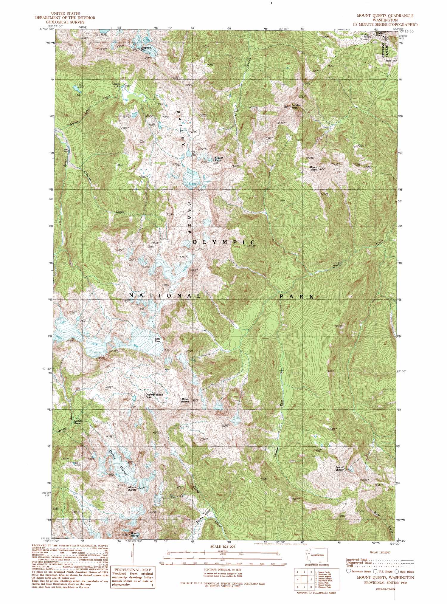
Mount Queets Topo Map Washington
To zoom in, hover over the map of Mount Queets
USGS Topo Quad 47123g5 - 1:24,000 scale
| Topo Map Name: | Mount Queets |
| USGS Topo Quad ID: | 47123g5 |
| Print Size: | ca. 21 1/4" wide x 27" high |
| Southeast Coordinates: | 47.75° N latitude / 123.5° W longitude |
| Map Center Coordinates: | 47.8125° N latitude / 123.5625° W longitude |
| U.S. State: | WA |
| Filename: | o47123g5.jpg |
| Download Map JPG Image: | Mount Queets topo map 1:24,000 scale |
| Map Type: | Topographic |
| Topo Series: | 7.5´ |
| Map Scale: | 1:24,000 |
| Source of Map Images: | United States Geological Survey (USGS) |
| Alternate Map Versions: |
Mount Queets WA 1990, updated 1990 Download PDF Buy paper map Mount Queets WA 1990, updated 1990 Download PDF Buy paper map Mount Queets WA 2011 Download PDF Buy paper map Mount Queets WA 2014 Download PDF Buy paper map |
1:24,000 Topo Quads surrounding Mount Queets
Lake Crescent |
Lake Sutherland |
Elwha |
Port Angeles |
Morse Creek |
Bogachiel Peak |
Mount Carrie |
Hurricane Hill |
Mount Angeles |
Maiden Peak |
Mount Tom |
Mount Olympus |
Mount Queets |
Mccartney Peak |
Wellesley Peak |
Bob Creek |
Kimta Peak |
Mount Christie |
Chimney Peak |
Mount Steel |
Finley Creek |
Bunch Lake |
Mount Hoquiam |
Mount Olsen |
Mount Skokomish |
> Back to 47123e1 at 1:100,000 scale
> Back to 47122a1 at 1:250,000 scale
> Back to U.S. Topo Maps home
Mount Queets topo map: Gazetteer
Mount Queets: Basins
Elwha Basin elevation 813m 2667′Queets Basin elevation 1030m 3379′
Mount Queets: Gaps
Bear Pass elevation 1692m 5551′Dodwell-Rixon Pass elevation 1458m 4783′
Mount Queets: Glaciers
Queets Glacier elevation 1672m 5485′Mount Queets: Lakes
Cream Lake elevation 1299m 4261′Mount Queets: Ranges
Bailey Range elevation 1709m 5606′Mount Queets: Streams
Cream Lake Creek elevation 761m 2496′Elkhorn Creek elevation 769m 2522′
Mount Queets: Summits
Dodger Point elevation 1744m 5721′Ludden Peak elevation 1772m 5813′
Mount Barnes elevation 1803m 5915′
Mount Ferry elevation 1854m 6082′
Mount Meany elevation 2002m 6568′
Mount Queets elevation 1966m 6450′
Mount Scott elevation 1796m 5892′
Mount Wilder elevation 1804m 5918′
Stephen Peak elevation 1926m 6318′
Mount Queets digital topo map on disk
Buy this Mount Queets topo map showing relief, roads, GPS coordinates and other geographical features, as a high-resolution digital map file on DVD: