Mount Angeles Topo Map Washington
To zoom in, hover over the map of Mount Angeles
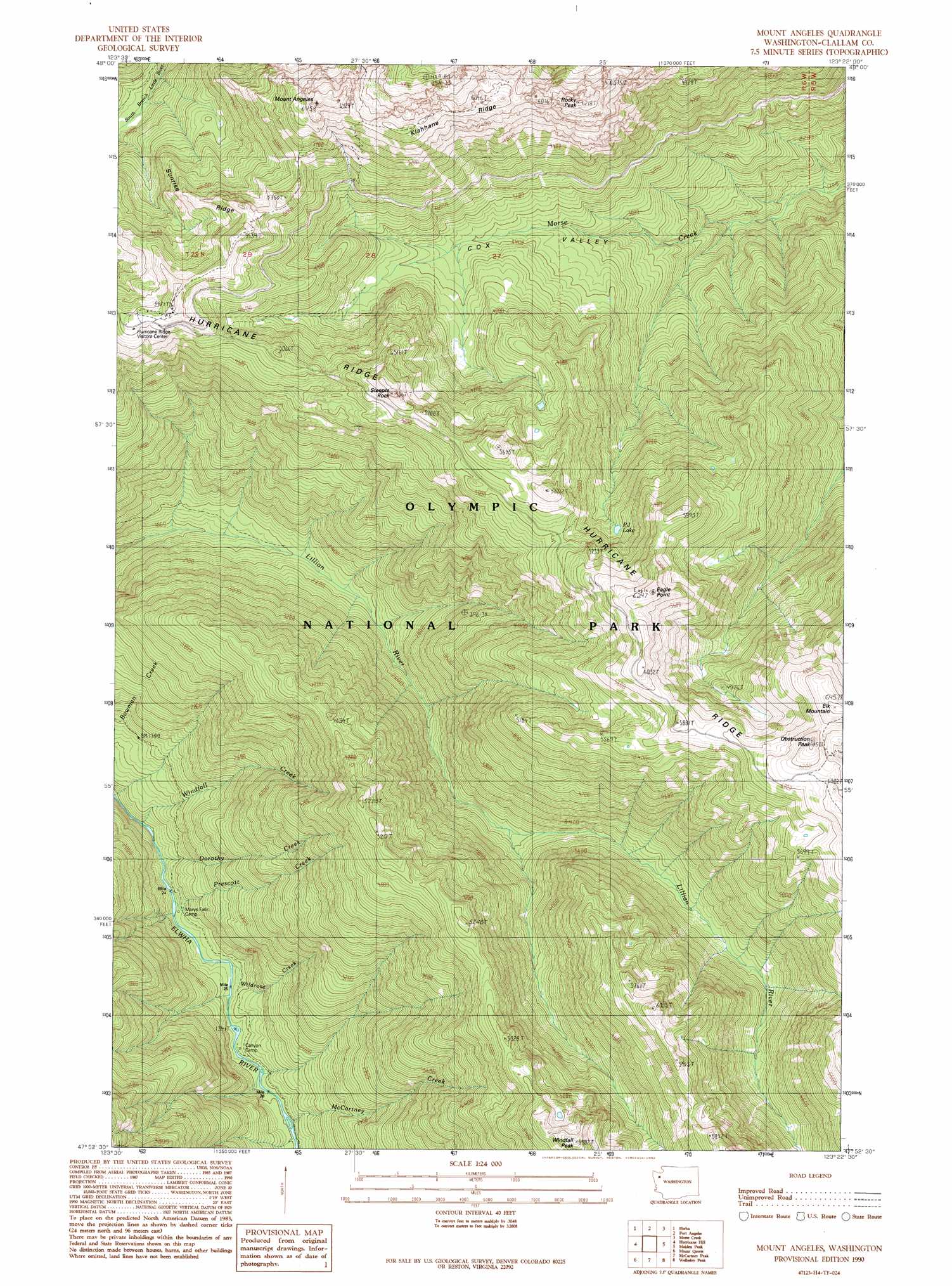
USGS Topo Quad 47123h4 - 1:24,000 scale
| Topo Map Name: | Mount Angeles |
| USGS Topo Quad ID: | 47123h4 |
| Print Size: | ca. 21 1/4" wide x 27" high |
| Southeast Coordinates: | 47.875° N latitude / 123.375° W longitude |
| Map Center Coordinates: | 47.9375° N latitude / 123.4375° W longitude |
| U.S. State: | WA |
| Filename: | o47123h4.jpg |
| Download Map JPG Image: | Mount Angeles topo map 1:24,000 scale |
| Map Type: | Topographic |
| Topo Series: | 7.5´ |
| Map Scale: | 1:24,000 |
| Source of Map Images: | United States Geological Survey (USGS) |
| Alternate Map Versions: |
Mount Angeles WA 1990, updated 1990 Download PDF Buy paper map Mount Angeles WA 1990, updated 1990 Download PDF Buy paper map Mount Angeles WA 1999, updated 2003 Download PDF Buy paper map Mount Angeles WA 2011 Download PDF Buy paper map Mount Angeles WA 2014 Download PDF Buy paper map |
1:24,000 Topo Quads surrounding Mount Angeles
Joyce |
Angeles Point |
Ediz Hook |
||
Lake Sutherland |
Elwha |
Port Angeles |
Morse Creek |
Carlsborg |
Mount Carrie |
Hurricane Hill |
Mount Angeles |
Maiden Peak |
Tyler Peak |
Mount Olympus |
Mount Queets |
Mccartney Peak |
Wellesley Peak |
Mount Deception |
Kimta Peak |
Mount Christie |
Chimney Peak |
Mount Steel |
The Brothers |
> Back to 47123e1 at 1:100,000 scale
> Back to 47122a1 at 1:250,000 scale
> Back to U.S. Topo Maps home
Mount Angeles topo map: Gazetteer
Mount Angeles: Flats
Cox Valley elevation 1044m 3425′Mount Angeles: Lakes
PJ Lake elevation 1390m 4560′Mount Angeles: Pillars
Steeple Rock elevation 1655m 5429′Mount Angeles: Ridges
Hurricane Ridge elevation 1819m 5967′Klahhane Ridge elevation 1788m 5866′
Sunrise Ridge elevation 1502m 4927′
Mount Angeles: Streams
Dorothy Creek elevation 384m 1259′Evergreen Creek elevation 436m 1430′
McCartney Creek elevation 437m 1433′
Prescott Creek elevation 378m 1240′
Wildrose Creek elevation 421m 1381′
Windfall Creek elevation 363m 1190′
Mount Angeles: Summits
Eagle Point elevation 1905m 6250′Elk Mountain elevation 1967m 6453′
Mount Angeles elevation 1930m 6332′
Obstruction Peak elevation 1966m 6450′
Rocky Peak elevation 1871m 6138′
Windfall Peak elevation 1819m 5967′
Mount Angeles digital topo map on disk
Buy this Mount Angeles topo map showing relief, roads, GPS coordinates and other geographical features, as a high-resolution digital map file on DVD: