Hurricane Hill Topo Map Washington
To zoom in, hover over the map of Hurricane Hill
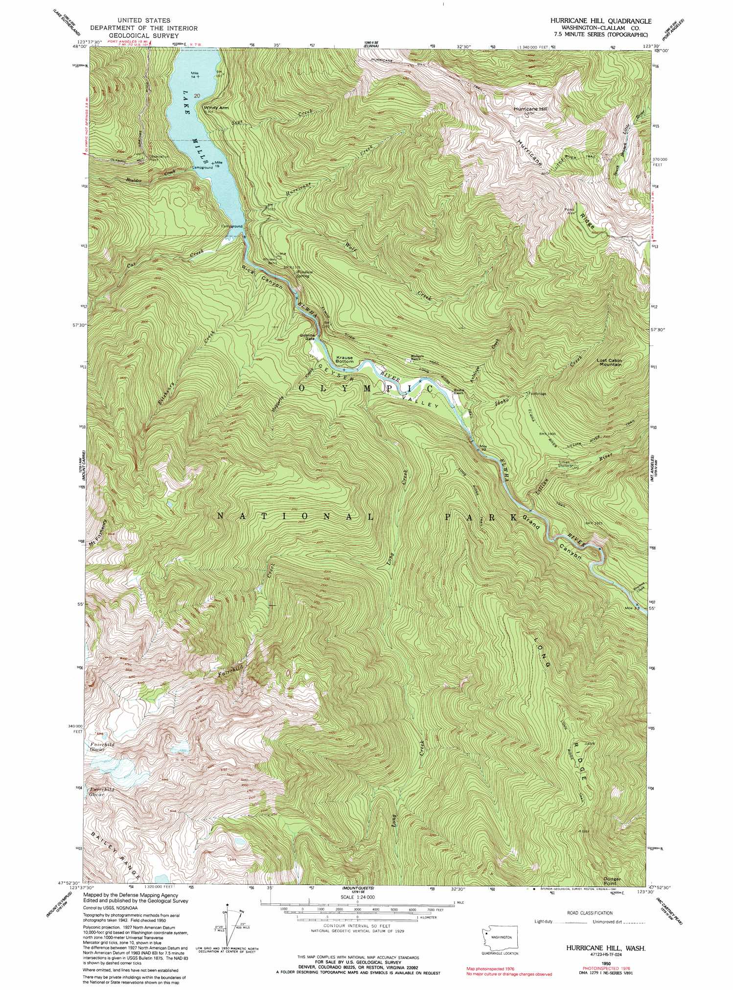
USGS Topo Quad 47123h5 - 1:24,000 scale
| Topo Map Name: | Hurricane Hill |
| USGS Topo Quad ID: | 47123h5 |
| Print Size: | ca. 21 1/4" wide x 27" high |
| Southeast Coordinates: | 47.875° N latitude / 123.5° W longitude |
| Map Center Coordinates: | 47.9375° N latitude / 123.5625° W longitude |
| U.S. State: | WA |
| Filename: | o47123h5.jpg |
| Download Map JPG Image: | Hurricane Hill topo map 1:24,000 scale |
| Map Type: | Topographic |
| Topo Series: | 7.5´ |
| Map Scale: | 1:24,000 |
| Source of Map Images: | United States Geological Survey (USGS) |
| Alternate Map Versions: |
Hurricane Hill WA 1950, updated 1955 Download PDF Buy paper map Hurricane Hill WA 1950, updated 1967 Download PDF Buy paper map Hurricane Hill WA 1950, updated 1977 Download PDF Buy paper map Hurricane Hill WA 1950, updated 1991 Download PDF Buy paper map Hurricane Hill WA 1950, updated 1991 Download PDF Buy paper map Hurricane Hill WA 1999, updated 2003 Download PDF Buy paper map Hurricane Hill WA 2011 Download PDF Buy paper map Hurricane Hill WA 2014 Download PDF Buy paper map |
1:24,000 Topo Quads surrounding Hurricane Hill
Disque |
Joyce |
Angeles Point |
Ediz Hook |
|
Lake Crescent |
Lake Sutherland |
Elwha |
Port Angeles |
Morse Creek |
Bogachiel Peak |
Mount Carrie |
Hurricane Hill |
Mount Angeles |
Maiden Peak |
Mount Tom |
Mount Olympus |
Mount Queets |
Mccartney Peak |
Wellesley Peak |
Bob Creek |
Kimta Peak |
Mount Christie |
Chimney Peak |
Mount Steel |
> Back to 47123e1 at 1:100,000 scale
> Back to 47122a1 at 1:250,000 scale
> Back to U.S. Topo Maps home
Hurricane Hill topo map: Gazetteer
Hurricane Hill: Flats
Krause Bottom elevation 230m 754′Hurricane Hill: Gaps
Goblin Gates elevation 210m 688′Hurricane Hill: Populated Places
Whiskey Bend elevation 375m 1230′Windy Arm elevation 260m 853′
Hurricane Hill: Ridges
Long Ridge elevation 1427m 4681′Hurricane Hill: Springs
Winslow Spring elevation 369m 1210′Hurricane Hill: Streams
Antelope Creek elevation 275m 902′Boulder Creek elevation 181m 593′
Bowman Creek elevation 366m 1200′
Cat Creek elevation 189m 620′
Fairchild Creek elevation 452m 1482′
Fitzhenry Creek elevation 183m 600′
Haggerty Creek elevation 210m 688′
Hurricane Creek elevation 1273m 4176′
Idaho Creek elevation 252m 826′
Lillian River elevation 334m 1095′
Long Creek elevation 225m 738′
Sege Creek elevation 194m 636′
Stukey Creek elevation 183m 600′
Wolf Creek elevation 218m 715′
Hurricane Hill: Summits
Hurricane Hill elevation 1757m 5764′Lost Cabin Mountain elevation 1212m 3976′
Hurricane Hill: Trails
Hurricane Hill Trail elevation 1461m 4793′Lillian River Trail elevation 624m 2047′
Little River Trail elevation 1318m 4324′
Long Ridge Trail elevation 1510m 4954′
Hurricane Hill: Valleys
Geyser Valley elevation 217m 711′Grand Canyon elevation 267m 875′
Rica Canyon elevation 190m 623′
Hurricane Hill digital topo map on disk
Buy this Hurricane Hill topo map showing relief, roads, GPS coordinates and other geographical features, as a high-resolution digital map file on DVD: