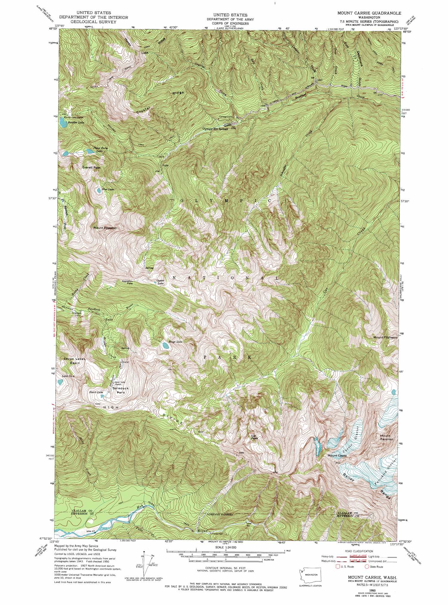
Mount Carrie Topo Map Washington
To zoom in, hover over the map of Mount Carrie
USGS Topo Quad 47123h6 - 1:24,000 scale
| Topo Map Name: | Mount Carrie |
| USGS Topo Quad ID: | 47123h6 |
| Print Size: | ca. 21 1/4" wide x 27" high |
| Southeast Coordinates: | 47.875° N latitude / 123.625° W longitude |
| Map Center Coordinates: | 47.9375° N latitude / 123.6875° W longitude |
| U.S. State: | WA |
| Filename: | o47123h6.jpg |
| Download Map JPG Image: | Mount Carrie topo map 1:24,000 scale |
| Map Type: | Topographic |
| Topo Series: | 7.5´ |
| Map Scale: | 1:24,000 |
| Source of Map Images: | United States Geological Survey (USGS) |
| Alternate Map Versions: |
Mount Carrie WA 1950, updated 1956 Download PDF Buy paper map Mount Carrie WA 1950, updated 1966 Download PDF Buy paper map Mount Carrie WA 1950, updated 1978 Download PDF Buy paper map Mount Carrie WA 1950, updated 1978 Download PDF Buy paper map Mount Carrie WA 1999, updated 2003 Download PDF Buy paper map Mount Carrie WA 2011 Download PDF Buy paper map Mount Carrie WA 2014 Download PDF Buy paper map |
1:24,000 Topo Quads surrounding Mount Carrie
Twin Rivers |
Disque |
Joyce |
Angeles Point |
Ediz Hook |
Mount Muller |
Lake Crescent |
Lake Sutherland |
Elwha |
Port Angeles |
Slide Peak |
Bogachiel Peak |
Mount Carrie |
Hurricane Hill |
Mount Angeles |
Owl Mountain |
Mount Tom |
Mount Olympus |
Mount Queets |
Mccartney Peak |
Kloochman Rock |
Bob Creek |
Kimta Peak |
Mount Christie |
Chimney Peak |
> Back to 47123e1 at 1:100,000 scale
> Back to 47122a1 at 1:250,000 scale
> Back to U.S. Topo Maps home
Mount Carrie topo map: Gazetteer
Mount Carrie: Flats
Sol Duc Park elevation 1372m 4501′Mount Carrie: Gaps
Appleton Pass elevation 1547m 5075′Mount Carrie: Glaciers
Carrie Glacier elevation 1810m 5938′Fairchild Glacier elevation 1852m 6076′
Mount Carrie: Lakes
Blue Lake elevation 1427m 4681′Boulder Lake elevation 1321m 4333′
Haigs Lake elevation 1429m 4688′
Heart Lake elevation 1458m 4783′
Lake Number 8 elevation 1411m 4629′
Mud Lake elevation 1397m 4583′
Oyster Lake elevation 1584m 5196′
Three Horse Lake elevation 1263m 4143′
Mount Carrie: Populated Places
Olympic Hot Springs elevation 654m 2145′Mount Carrie: Ridges
Crystal Ridge elevation 1315m 4314′High Divide elevation 1502m 4927′
Mount Carrie: Streams
Bridge Creek elevation 1025m 3362′Cougar Creek elevation 435m 1427′
Crystal Creek elevation 578m 1896′
Deep Creek elevation 397m 1302′
Deer Creek elevation 438m 1437′
Falls Creek elevation 304m 997′
Glacier Creek elevation 408m 1338′
Hell Creek elevation 538m 1765′
North Fork Boulder Creek elevation 734m 2408′
Rocky Creek elevation 908m 2979′
Schoeffel Creek elevation 405m 1328′
Slide Creek elevation 299m 980′
South Fork Boulder Creek elevation 734m 2408′
Mount Carrie: Summits
Cat Peak elevation 1796m 5892′Everett Peak elevation 1585m 5200′
Mount Appleton elevation 1821m 5974′
Mount Carrie elevation 2125m 6971′
Mount Fairchild elevation 2108m 6916′
Mount Fitzhenry elevation 1842m 6043′
Mount Carrie: Trails
Boulder Lake Trail elevation 997m 3270′Hoh River Trail elevation 325m 1066′
Mount Carrie: Valleys
Deadmans Gulch elevation 381m 1250′Mount Carrie digital topo map on disk
Buy this Mount Carrie topo map showing relief, roads, GPS coordinates and other geographical features, as a high-resolution digital map file on DVD: