Slide Peak Topo Map Washington
To zoom in, hover over the map of Slide Peak
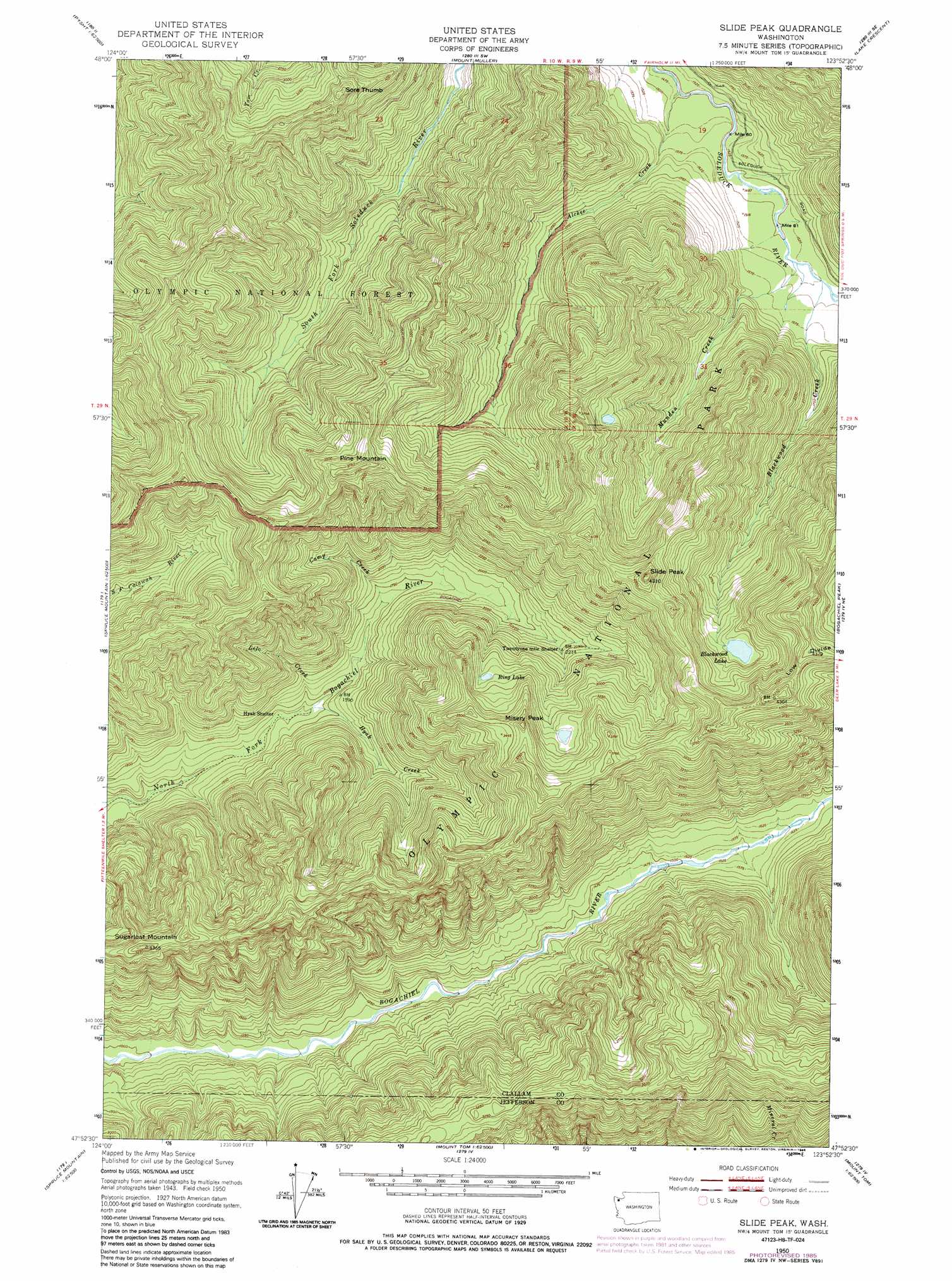
USGS Topo Quad 47123h8 - 1:24,000 scale
| Topo Map Name: | Slide Peak |
| USGS Topo Quad ID: | 47123h8 |
| Print Size: | ca. 21 1/4" wide x 27" high |
| Southeast Coordinates: | 47.875° N latitude / 123.875° W longitude |
| Map Center Coordinates: | 47.9375° N latitude / 123.9375° W longitude |
| U.S. State: | WA |
| Filename: | o47123h8.jpg |
| Download Map JPG Image: | Slide Peak topo map 1:24,000 scale |
| Map Type: | Topographic |
| Topo Series: | 7.5´ |
| Map Scale: | 1:24,000 |
| Source of Map Images: | United States Geological Survey (USGS) |
| Alternate Map Versions: |
Slide Peak WA 1950, updated 1956 Download PDF Buy paper map Slide Peak WA 1950, updated 1970 Download PDF Buy paper map Slide Peak WA 1950, updated 1978 Download PDF Buy paper map Slide Peak WA 1950, updated 1986 Download PDF Buy paper map Slide Peak WA 1995, updated 1997 Download PDF Buy paper map Slide Peak WA 2011 Download PDF Buy paper map Slide Peak WA 2014 Download PDF Buy paper map |
| FStopo: | US Forest Service topo Slide Peak is available: Download FStopo PDF Download FStopo TIF |
1:24,000 Topo Quads surrounding Slide Peak
West Of Pysht |
Pysht |
Twin Rivers |
Disque |
Joyce |
Deadmans Hill |
Snider Peak |
Mount Muller |
Lake Crescent |
Lake Sutherland |
Indian Pass |
Hunger Mountain |
Slide Peak |
Bogachiel Peak |
Mount Carrie |
Winfield Creek |
Spruce Mountain |
Owl Mountain |
Mount Tom |
Mount Olympus |
Christmas Creek |
Stequaleho Creek |
Kloochman Rock |
Bob Creek |
Kimta Peak |
> Back to 47123e1 at 1:100,000 scale
> Back to 47122a1 at 1:250,000 scale
> Back to U.S. Topo Maps home
Slide Peak topo map: Gazetteer
Slide Peak: Lakes
Blackwood Lake elevation 970m 3182′Ring Lake elevation 884m 2900′
Slide Peak: Streams
Alckee Creek elevation 456m 1496′Blackwood Creek elevation 466m 1528′
Camp Creek elevation 503m 1650′
Hyak Creek elevation 431m 1414′
Lolo Creek elevation 426m 1397′
Munden Creek elevation 463m 1519′
Slide Peak: Summits
Misery Peak elevation 1093m 3585′Pine Mountain elevation 1139m 3736′
Slide Peak elevation 1306m 4284′
Sore Thumb elevation 1147m 3763′
Sugarloaf Mountain elevation 1033m 3389′
Slide Peak: Trails
Bogachiel Trail elevation 575m 1886′Slide Peak digital topo map on disk
Buy this Slide Peak topo map showing relief, roads, GPS coordinates and other geographical features, as a high-resolution digital map file on DVD: