Hungry Jack Lake Topo Map Minnesota
To zoom in, hover over the map of Hungry Jack Lake
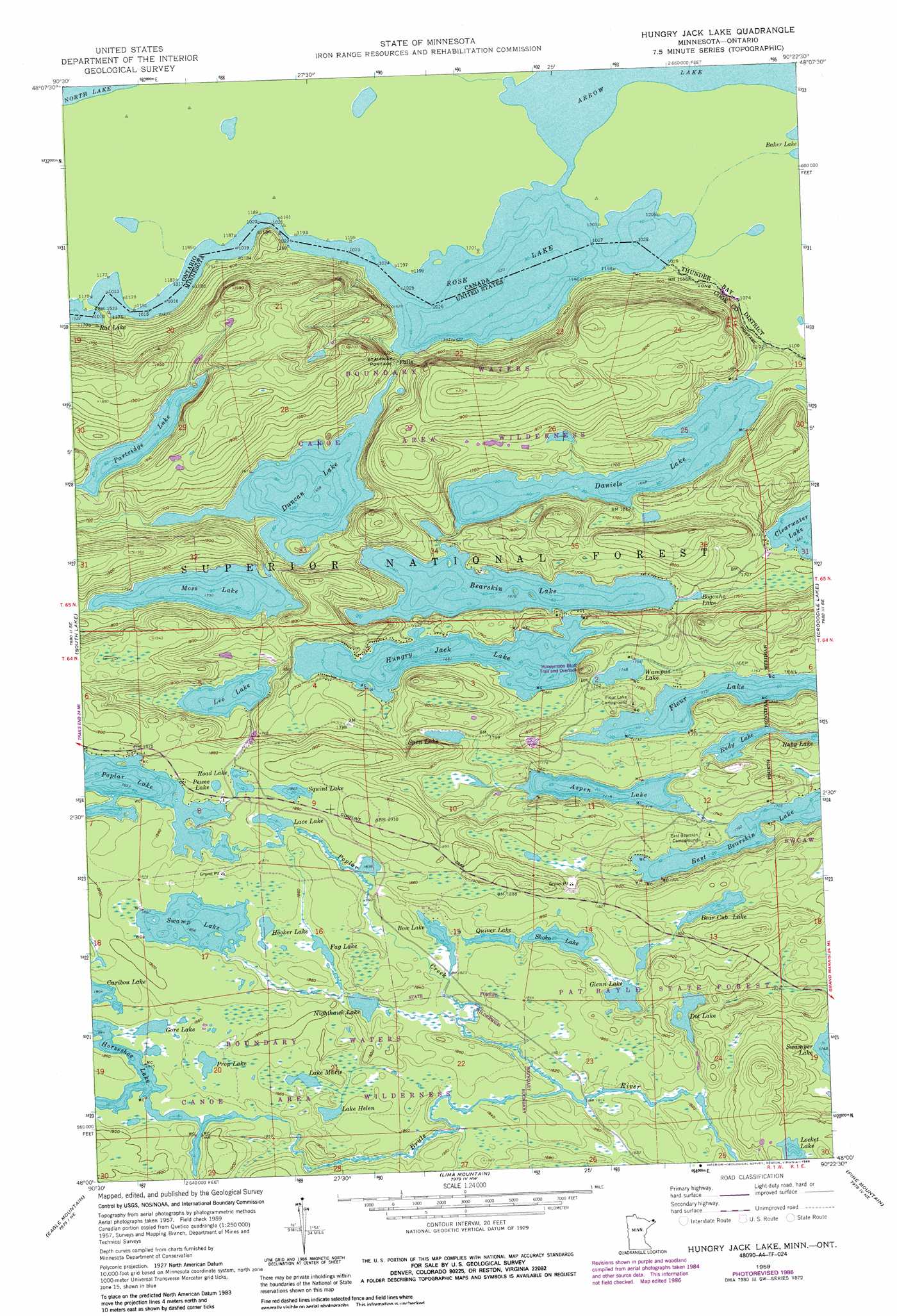
USGS Topo Quad 48090a4 - 1:24,000 scale
| Topo Map Name: | Hungry Jack Lake |
| USGS Topo Quad ID: | 48090a4 |
| Print Size: | ca. 21 1/4" wide x 27" high |
| Southeast Coordinates: | 48° N latitude / 90.375° W longitude |
| Map Center Coordinates: | 48.0625° N latitude / 90.4375° W longitude |
| U.S. State: | MN |
| Filename: | o48090a4.jpg |
| Download Map JPG Image: | Hungry Jack Lake topo map 1:24,000 scale |
| Map Type: | Topographic |
| Topo Series: | 7.5´ |
| Map Scale: | 1:24,000 |
| Source of Map Images: | United States Geological Survey (USGS) |
| Alternate Map Versions: |
Hungry Jack Lake MN 1959, updated 1962 Download PDF Buy paper map Hungry Jack Lake MN 1959, updated 1965 Download PDF Buy paper map Hungry Jack Lake MN 1959, updated 1978 Download PDF Buy paper map Hungry Jack Lake MN 1959, updated 1986 Download PDF Buy paper map Hungry Jack Lake MN 2011 Download PDF Buy paper map Hungry Jack Lake MN 2013 Download PDF Buy paper map Hungry Jack Lake MN 2016 Download PDF Buy paper map |
| FStopo: | US Forest Service topo Hungry Jack Lake is available: Download FStopo PDF Download FStopo TIF |
1:24,000 Topo Quads surrounding Hungry Jack Lake
Gunflint Lake |
South Lake |
Hungry Jack Lake |
Crocodile Lake |
Pine Lake West |
Brule Lake |
Eagle Mountain |
Lima Mountain |
Pine Mountain |
Northern Light Lake |
Tait Lake |
Mark Lake |
Devil Track Lake |
Grand Marais |
Kadunce River |
> Back to 48090a1 at 1:100,000 scale
> Back to 48090a1 at 1:250,000 scale
> Back to U.S. Topo Maps home
Hungry Jack Lake topo map: Gazetteer
Hungry Jack Lake: Lakes
Aspen Lake elevation 524m 1719′Bear Cub Lake elevation 565m 1853′
Bearskin Lake elevation 512m 1679′
Bogenho Lake elevation 512m 1679′
Bow Lake elevation 558m 1830′
Daniels Lake elevation 502m 1646′
Dot Lake elevation 554m 1817′
Duncan Lake elevation 506m 1660′
Fag Lake elevation 566m 1856′
Flour Lake elevation 528m 1732′
Glenn Lake elevation 559m 1833′
Gore Lake elevation 564m 1850′
Hooker Lake elevation 566m 1856′
Horseshoe Lake elevation 562m 1843′
Hungry Jack Lake elevation 513m 1683′
Lace Lake elevation 562m 1843′
Lake Helen elevation 566m 1856′
Lake Marie elevation 566m 1856′
Leo Lake elevation 534m 1751′
Locket Lake elevation 582m 1909′
Moss Lake elevation 527m 1729′
Nighthawk Lake elevation 558m 1830′
Partridge Lake elevation 541m 1774′
Pewee Lake elevation 569m 1866′
Prop Lake elevation 570m 1870′
Quiver Lake elevation 558m 1830′
Road Lake elevation 570m 1870′
Rose Lake elevation 463m 1519′
Ruby Lake elevation 533m 1748′
Rudy Lake elevation 533m 1748′
Shoko Lake elevation 559m 1833′
Spen Lake elevation 540m 1771′
Squint Lake elevation 569m 1866′
Swamp Lake elevation 569m 1866′
Wampus Lake elevation 533m 1748′
Hungry Jack Lake: Streams
Poplar Creek elevation 554m 1817′Hungry Jack Lake: Trails
Long Portage elevation 498m 1633′Stairway Portage elevation 502m 1646′
Hungry Jack Lake digital topo map on disk
Buy this Hungry Jack Lake topo map showing relief, roads, GPS coordinates and other geographical features, as a high-resolution digital map file on DVD: