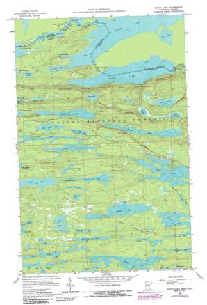
South Lake Topo Map Minnesota
To zoom in, hover over the map of South Lake
USGS Topo Quad 48090a5 - 1:24,000 scale
| Topo Map Name: | South Lake |
| USGS Topo Quad ID: | 48090a5 |
| Print Size: | ca. 21 1/4" wide x 27" high |
| Southeast Coordinates: | 48° N latitude / 90.5° W longitude |
| Map Center Coordinates: | 48.0625° N latitude / 90.5625° W longitude |
| U.S. State: | MN |
| Filename: | o48090a5.jpg |
| Download Map JPG Image: | South Lake topo map 1:24,000 scale |
| Map Type: | Topographic |
| Topo Series: | 7.5´ |
| Map Scale: | 1:24,000 |
| Source of Map Images: | United States Geological Survey (USGS) |
| Alternate Map Versions: |
South Lake MN 1960, updated 1962 Download PDF Buy paper map South Lake MN 1960, updated 1965 Download PDF Buy paper map South Lake MN 1960, updated 1984 Download PDF Buy paper map South Lake MN 1960, updated 1986 Download PDF Buy paper map South Lake MN 2011 Download PDF Buy paper map South Lake MN 2013 Download PDF Buy paper map South Lake MN 2016 Download PDF Buy paper map |
| FStopo: | US Forest Service topo South Lake is available: Download FStopo PDF Download FStopo TIF |
1:24,000 Topo Quads surrounding South Lake
> Back to 48090a1 at 1:100,000 scale
> Back to 48090a1 at 1:250,000 scale
> Back to U.S. Topo Maps home
South Lake topo map: Gazetteer
South Lake: Bays
Frances Bay elevation 471m 1545′South Lake: Lakes
Allen Lake elevation 566m 1856′Alpha Lake elevation 594m 1948′
Beta Lake elevation 599m 1965′
Birch Lake elevation 543m 1781′
Caribou Lake elevation 568m 1863′
Creeper Lake elevation 594m 1948′
Dunn Lake elevation 510m 1673′
East Otter Lake elevation 509m 1669′
East Pope Lake elevation 573m 1879′
Flicker Lake elevation 582m 1909′
Gaskin Lake elevation 570m 1870′
Henson Lake elevation 578m 1896′
Hoat Lake elevation 508m 1666′
Iron Lake elevation 565m 1853′
Jump Lake elevation 567m 1860′
Larsen Lake elevation 576m 1889′
Little Gunflint Lake elevation 468m 1535′
Little Mayhew Lake elevation 550m 1804′
Little North Lake elevation 464m 1522′
Little Rush Lake elevation 588m 1929′
Lizz Lake elevation 572m 1876′
Lum Lake elevation 596m 1955′
Mayhew Lake elevation 554m 1817′
Meeds Lake elevation 572m 1876′
Misplaced Lake elevation 589m 1932′
Moon Lake elevation 583m 1912′
Mucker Lake elevation 504m 1653′
North Lake elevation 472m 1548′
One Island Lake elevation 595m 1952′
Otto Lakes elevation 586m 1922′
Pillsbery Lake elevation 575m 1886′
Poplar Lake elevation 565m 1853′
Portage Lake elevation 569m 1866′
Prune Lake elevation 576m 1889′
Rat Lake elevation 471m 1545′
Rush Lake elevation 592m 1942′
Saucer Lake elevation 475m 1558′
Skipper Lake elevation 587m 1925′
Snack Lake elevation 570m 1870′
Sock Lake elevation 551m 1807′
South Lake elevation 472m 1548′
Surber Lake elevation 588m 1929′
Susana Lake elevation 479m 1571′
Swallow Lake elevation 579m 1899′
Topper Lake elevation 551m 1807′
West Pope Lake elevation 571m 1873′
Whisker Lake elevation 533m 1748′
South Lake: Parks
Height of Land Portage Historical Marker elevation 487m 1597′South Lake: Trails
Gunflint Trail elevation 572m 1876′Height of Land Portage elevation 481m 1578′
South Lake Portage elevation 474m 1555′
South Lake digital topo map on disk
Buy this South Lake topo map showing relief, roads, GPS coordinates and other geographical features, as a high-resolution digital map file on DVD:


