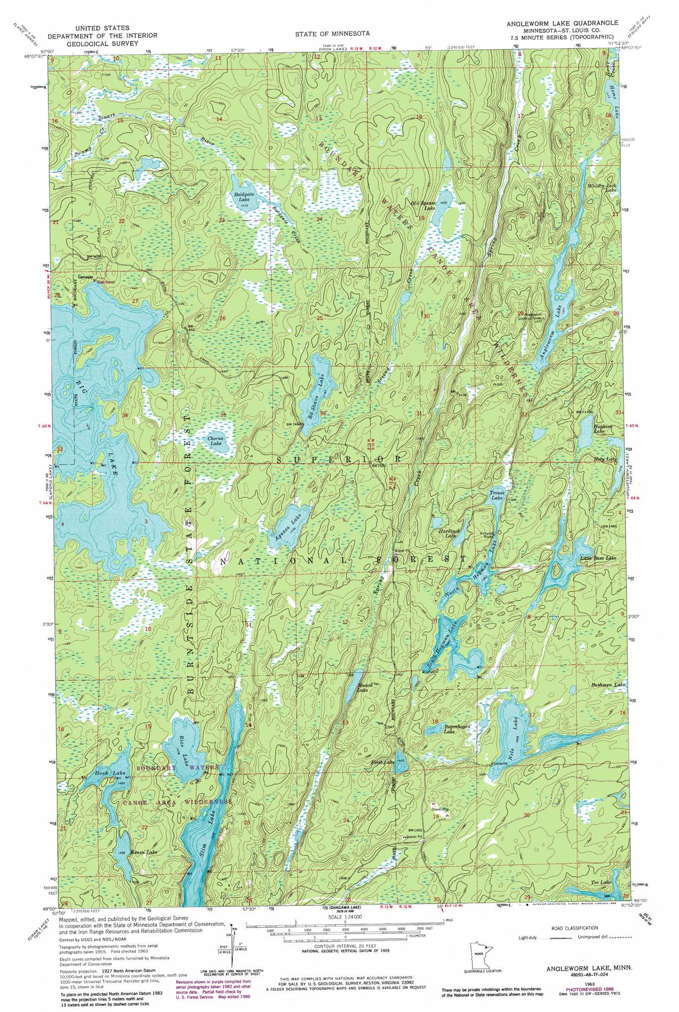
Angleworm Lake Topo Map Minnesota
To zoom in, hover over the map of Angleworm Lake
USGS Topo Quad 48091a8 - 1:24,000 scale
| Topo Map Name: | Angleworm Lake |
| USGS Topo Quad ID: | 48091a8 |
| Print Size: | ca. 21 1/4" wide x 27" high |
| Southeast Coordinates: | 48° N latitude / 91.875° W longitude |
| Map Center Coordinates: | 48.0625° N latitude / 91.9375° W longitude |
| U.S. State: | MN |
| Filename: | o48091a8.jpg |
| Download Map JPG Image: | Angleworm Lake topo map 1:24,000 scale |
| Map Type: | Topographic |
| Topo Series: | 7.5´ |
| Map Scale: | 1:24,000 |
| Source of Map Images: | United States Geological Survey (USGS) |
| Alternate Map Versions: |
Angleworm Lake MN 1963, updated 1964 Download PDF Buy paper map Angleworm Lake MN 1963, updated 1986 Download PDF Buy paper map Angleworm Lake MN 2011 Download PDF Buy paper map Angleworm Lake MN 2013 Download PDF Buy paper map Angleworm Lake MN 2016 Download PDF Buy paper map |
| FStopo: | US Forest Service topo Angleworm Lake is available: Download FStopo PDF Download FStopo TIF |
1:24,000 Topo Quads surrounding Angleworm Lake
Takucmich Lake |
Coleman Island |
|||
Shell Lake |
Lake Agnes |
Iron Lake |
Friday Bay |
Jackfish Lake |
Bootleg Lake |
Lapond Lake |
Angleworm Lake |
Fourtown Lake |
Basswood Lake West |
Chad Lake |
Crab Lake |
Shagawa Lake |
Ely |
Farm Lake |
Soudan |
Eagles Nest |
Bear Island |
Kangas Bay |
Bogberry Lake |
> Back to 48091a1 at 1:100,000 scale
> Back to 48090a1 at 1:250,000 scale
> Back to U.S. Topo Maps home
Angleworm Lake topo map: Gazetteer
Angleworm Lake: Cliffs
Pictured Rocks elevation 450m 1476′Angleworm Lake: Lakes
Agassa Lake elevation 444m 1456′Angleworm Lake elevation 433m 1420′
Baldpate Lake elevation 430m 1410′
Big Lake elevation 430m 1410′
Chorus Lake elevation 438m 1437′
Ed Shave Lake elevation 447m 1466′
First Lake elevation 437m 1433′
Hardtack Lake elevation 450m 1476′
Hook Lake elevation 454m 1489′
Hopkins Lake elevation 449m 1473′
Hunch Lake elevation 443m 1453′
Keneu Lake elevation 456m 1496′
Little Bass Lake elevation 448m 1469′
Nels Lake elevation 428m 1404′
Nightingale Lake elevation 428m 1404′
North Hegman Lake elevation 446m 1463′
Regenbogen Lake elevation 437m 1433′
Rice Lake elevation 451m 1479′
Slim Lake elevation 444m 1456′
South Hegman Lake elevation 445m 1459′
Tee Lake elevation 438m 1437′
Trease Lake elevation 446m 1463′
Angleworm Lake: Streams
Baldpate Creek elevation 430m 1410′Second Creek elevation 396m 1299′
Swamp Creek elevation 408m 1338′
Angleworm Lake: Trails
Stuart Portage elevation 447m 1466′Angleworm Lake digital topo map on disk
Buy this Angleworm Lake topo map showing relief, roads, GPS coordinates and other geographical features, as a high-resolution digital map file on DVD: